• About
  • Special Reports
  • Topics
    • Climate
    • Earth Science
    • Oceans
    • Space & Planets
    • Health & Ecosystems
    • Culture & Policy
    • Education & Careers
    • Opinions
  • Projects
    • Postcards From the Field
    • ENGAGE
    • Editors’ Highlights
    • Editors’ Vox
    • Eos en Español
    • Eos 简体中文版
    • Print Archive: 2015–2025
  • Policy Tracker
  • Blogs
    • Research & Developments
    • The Landslide Blog
  • Newsletter
  • Submit to Eos
  • AGU.org
  • Career Center
  • Join AGU
  • Give to AGU
  • About
  • Special Reports
  • Topics
    • Climate
    • Earth Science
    • Oceans
    • Space & Planets
    • Health & Ecosystems
    • Culture & Policy
    • Education & Careers
    • Opinions
  • Projects
    • Postcards From the Field
    • ENGAGE
    • Editors’ Highlights
    • Editors’ Vox
    • Eos en Español
    • Eos 简体中文版
    • Print Archive: 2015–2025
  • Policy Tracker
  • Blogs
    • Research & Developments
    • The Landslide Blog
  • Newsletter
  • Submit to Eos
Skip to content
  • AGU.org
  • Career Center
  • Join AGU
  • Give to AGU
Eos

Eos

Science News by AGU

Support Eos
Sign Up for Newsletter
  • About
  • Special Reports
  • Topics
    • Climate
    • Earth Science
    • Oceans
    • Space & Planets
    • Health & Ecosystems
    • Culture & Policy
    • Education & Careers
    • Opinions
  • Projects
    • Postcards From the Field
    • ENGAGE
    • Editors’ Highlights
    • Editors’ Vox
    • Eos en Español
    • Eos 简体中文版
    • Print Archive: 2015–2025
  • Policy Tracker
  • Blogs
    • Research & Developments
    • The Landslide Blog
  • Newsletter
  • Submit to Eos

cities

The Pyramid of the Sun at Teotihuacan
Posted inENGAGE, News

Mapping Teotihuacan’s Past, Present, and Future

by Humberto Basilio 6 January 20229 May 2023

A new lidar project reveals how mining and urban expansion have put one of Mexico’s most iconic cultural heritage sites at risk.

Five people planting young trees in Houston field
Posted inNews

Native Super Trees Could Provide Climate Solutions to Houston

by Graycen Wheeler 15 December 20211 June 2023

A Houston nonprofit identified 14 native “super tree” species that are particularly promising for mitigating climate change and public health concerns.

An aerial view of Vancouver
Posted inENGAGE, News

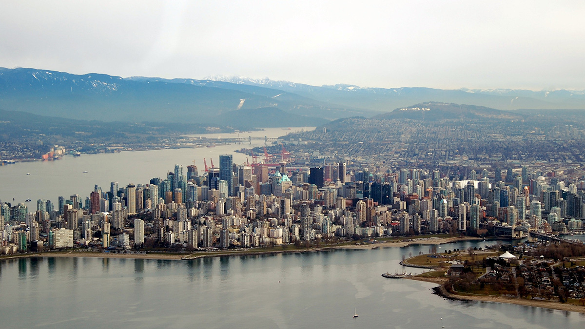
Crowdsourced Science Helps Map Vancouver’s “Smellscape”

by Brittney J. Miller 14 December 202127 March 2023

Exposure to stinky odors can affect human health, but quantifying smells can be difficult.

Birds flying over a city at dawn
Posted inENGAGE, News

Bright Lights, Big Cities Attract Migratory Birds

by Brian Phan 14 December 202127 March 2023

The first stopover site map for U.S. migratory birds reveals the attraction of urban light pollution.

View of the Los Angeles basin with mountains in the background
Posted inENGAGE, News

Earthquakes Ripple Through 3D Printed Models of Los Angeles

Katherine Kornei, Science Writer by Katherine Kornei 13 December 202127 March 2023

Using stainless steel models, researchers find that high-frequency seismic waves—the most damaging to buildings—are attenuated in the Los Angeles sedimentary basin.

Plot comparing the efficiency with which flood risk management is carried out and the effect on addressing socio-economic inequality.
Posted inEditors' Highlights

Pro-Poor Flood Risk Management Can Reduce Urban Inequality

by Jim Hall 7 December 202121 February 2023

Rich people’s aversion to flood risk results in poor people living in the most vulnerable locations poverty. Pro-poor flood risk management policies could have a significant impact on inequality.

Canoers paddle along the Anacostia near Kenilworth Park in Washington, D.C.
Posted inFeatures

The Capital’s Waterways Could Be Swimmable by 2030

Mark Betancourt, Freelance Journalist by Mark Betancourt 22 November 202124 November 2021

Scientists, community groups, and the Clean Water Act are behind Washington, D.C.’s massive project to reduce combined sewer overflows by 96%.

Posted inENGAGE, News

Sobreviviendo en la periferia de una ciudad de terremotos

by Humberto Basilio 17 November 202128 March 2023

La Ciudad de México es una de las áreas urbanas más propensas a desastres del mundo. Después de un terremoto, las comunidades marginadas que viven en la periferia de la ciudad están expuestas a más peligros que el simple derrumbe de edificios.

A map showing heat distribution in and around Boston with yellow representing cooler areas and darker shades of orange representing hotter areas
Posted inENGAGE, News

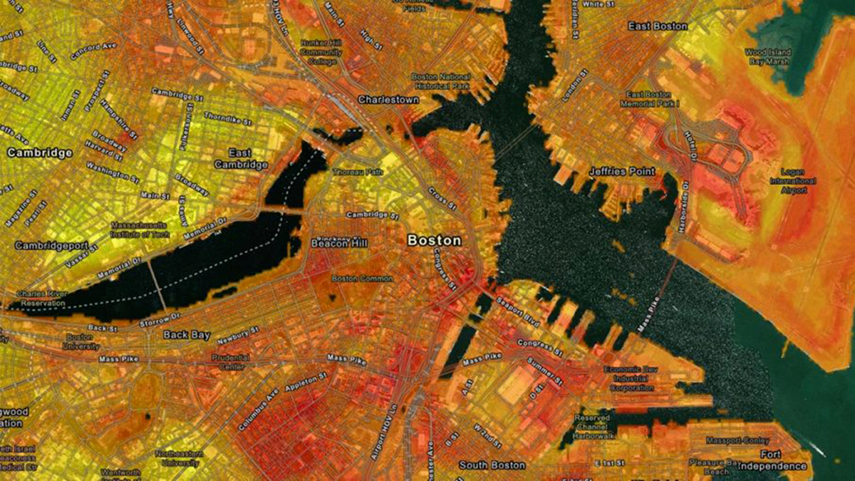
Neighborhoods Are Feeling the Heat of Climate Change

by Jackie Rocheleau 29 October 202128 March 2023

It’s no secret there are disparities in exposure to climate change’s effects. A new study zeroes in on the demographics of neighborhoods subjected to the hottest temperatures.

Heavy-duty diesel vehicles drive inequalities in air quality in cities across the United States.
Posted inENGAGE, Research Spotlights

An Eye in the Sky Tracks Air Pollution Inequality in U.S. Cities

Aaron Sidder, freelance science writer by Aaron Sidder 27 October 202128 March 2023

A new study uses its data to show that diesel traffic is the largest source of pollution inequality across racial and economic divides

Posts pagination

Newer posts 1 … 7 8 9 10 11 … 17 Older posts
Over a dark blue-green square appear the words Special Report: The State of the Science 1 Year On.

Features from AGU Publications

Research Spotlights

Improving Eddy Tower Evapotranspiration Estimates

20 May 202620 May 2026
Editors' Highlights

Recycled Rocks Reveal Subduction Zone Dynamics Off Baja California

21 May 202621 May 2026
Editors' Vox

The Impact of Advocacy: American Geophysical Union’s Days of Action

14 May 202613 May 2026
Eos logo at left; AGU logo at right

About Eos
ENGAGE
Awards
Contact

Advertise
Submit
Career Center
Sitemap

© 2026 American Geophysical Union. All rights reserved Powered by Newspack