• About
  • Sections
  • Topics
    • Climate
    • Earth Science
    • Oceans
    • Space & Planets
    • Health & Ecosystems
    • Culture & Policy
    • Education & Careers
    • Opinions
  • Projects
    • ENGAGE
    • Editors’ Highlights
    • Editors’ Vox
    • Eos en Español
    • Eos 简体中文版
    • Print Archive
  • Blogs
    • Research & Developments
    • The Landslide Blog
  • Newsletter
  • Submit to Eos
  • AGU.org
  • Career Center
  • Join AGU
  • Give to AGU
  • About
  • Sections
  • Topics
    • Climate
    • Earth Science
    • Oceans
    • Space & Planets
    • Health & Ecosystems
    • Culture & Policy
    • Education & Careers
    • Opinions
  • Projects
    • ENGAGE
    • Editors’ Highlights
    • Editors’ Vox
    • Eos en Español
    • Eos 简体中文版
    • Print Archive
  • Blogs
    • Research & Developments
    • The Landslide Blog
  • Newsletter
  • Submit to Eos
Skip to content
  • AGU.org
  • Career Center
  • Join AGU
  • Give to AGU
Eos

Eos

Science News by AGU

Support Eos
Sign Up for Newsletter
  • About
  • Sections
  • Topics
    • Climate
    • Earth Science
    • Oceans
    • Space & Planets
    • Health & Ecosystems
    • Culture & Policy
    • Education & Careers
    • Opinions
  • Projects
    • ENGAGE
    • Editors’ Highlights
    • Editors’ Vox
    • Eos en Español
    • Eos 简体中文版
    • Print Archive
  • Blogs
    • Research & Developments
    • The Landslide Blog
  • Newsletter
  • Submit to Eos

Earth science

Satellite photo of a massive ice shelf with a couple of large cracks
Posted inResearch Spotlights

Melting Below the Pine Island Ice Shelf Minds the Gap

Sarah Derouin, Science Writer by Sarah Derouin 3 October 20223 October 2022

New research shows that increased calving from West Antarctica’s Pine Island Ice Shelf will likely drive increased circulation of warm water—and melting—below the ice.

Tres rescatistas, vestidos en color naranja, buscan entre los escombros de un edificio caído. Detrás del edificio caído hay otro edificio de ladrillos rojos, el cual aún se encuentra de pie, pero tiene algunas paredes dañadas.
Posted inNews

¿Tienen los terremotos y las placas tectónicas una relación bidireccional?

Tim Hornyak, Science Writer by Tim Hornyak 3 October 20224 October 2022

Un terremoto catastrófico en Turquía que sucedió en 1999 cambió el movimiento de la placa de Anatolia, según un estudio que podría modificar los fundamentos de modelamiento de los terremotos.

Image overlooking a rocky coastline and water just after sunset with a bright blue line representing a fiber-optic cable curving over the water and rocks
Posted inResearch Spotlights

Internet Cable Reveals the Source of Underwater Vibrations

by Saima May Sidik 30 September 202214 May 2024

A novel use of an existing fiber-optic cable off the coast of Spain has clued scientists in to how seismic noise is generated in the ocean.

Aerial view of a muddy river delta with meandering stream channels emanating from a river emerging from a forest
Posted inResearch Spotlights

When Projecting Coastal Resilience, Sediment Compaction Is Key

by Morgan Rehnberg 30 September 202230 September 2022

The addition of new sediment helps build up lowland environments like deltas and marshes, but it also compacts materials beneath it—a vital, but often overlooked, factor in landscape evolution studies.

Researchers Roman Sidortsov and Timothy Scarlett stand in the snowy weather looking at a historical map of a mine site.
Posted inNews

Can Decommissioned Mines Become Green Power Generators?

Sarah Derouin, Science Writer by Sarah Derouin 29 September 202229 September 2022

A new report supports the idea that underground mines can be transformed into energy storage facilities, adding the possibility of on-demand, carbon-free power to energy grids.

A bright red, orange, and yellow thermal image of London and the surrounding area maps hotter and cooler areas of the city. The center of the image is the city of London, which is yellow, indicating that it is hotter than surrounding suburbs, which appear in varying shades of orange and red. The suburbs tend to become cooler, and appear darker red, moving toward the edges of the image. The River Thames snakes from right to left across the center of the image. It and several water reservoirs to the left of center are black, indicating that they are much cooler than the neighboring land.
Posted inResearch Spotlights

Satellites Can Accurately Take Earth’s Temperature

by Rebecca Dzombak 28 September 202228 September 2022

Satellite-based measurements of land surface temperature may prove to be an essential pairing with near-surface air temperatures to understand global warming and cooling trends.

Figure 1 from the paper, showing a schematic of key processes controlling coastal carbon dynamics.
Posted inEditors' Highlights
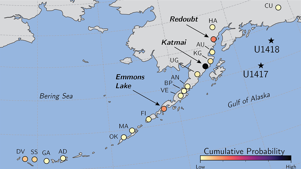
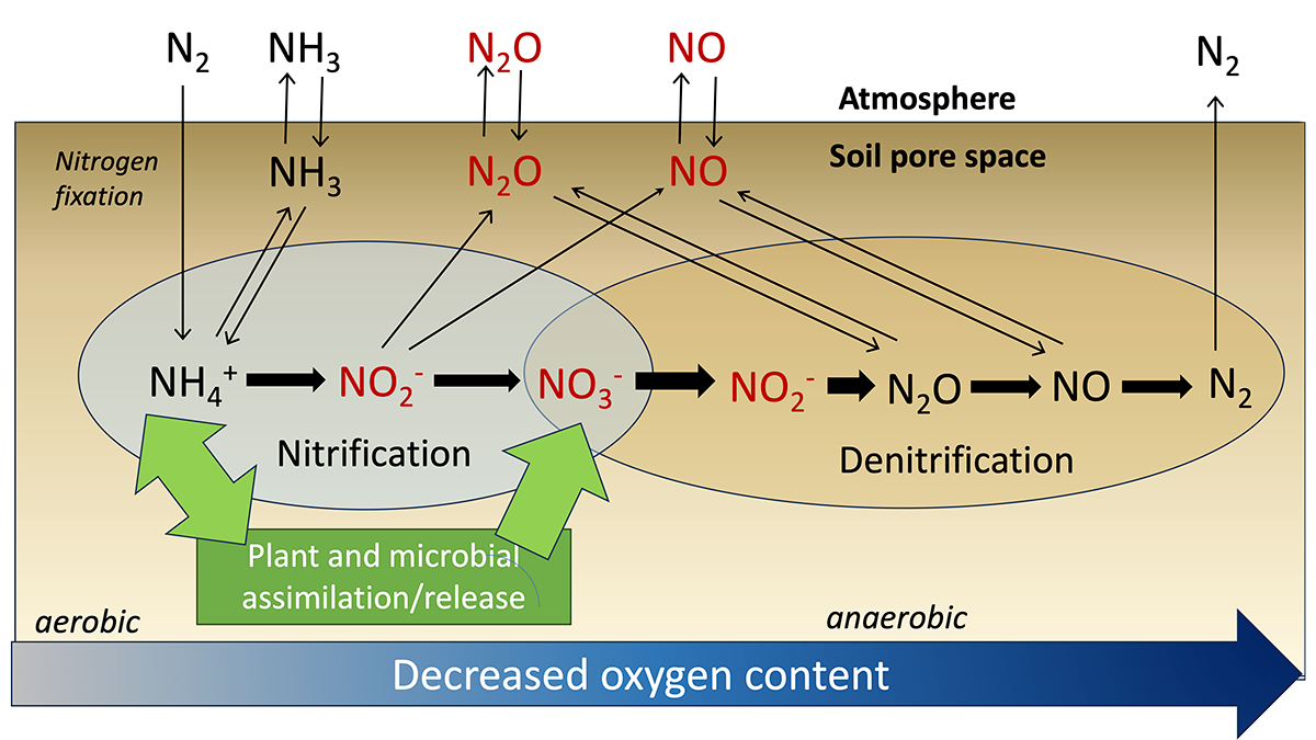
Substantial Advance Towards a Global Coastal Carbon Model

by Andreas Oschlies 27 September 202220 October 2022

First simulations of a new biogeochemistry-circulation coastal grid refinement demonstrate seamless inclusion of small-scale coastal processes in a state-of-the-art Earth system model.

View of a bay with buildings and vehicles in the foreground
Posted inFeatures

Seismic Sources in the Aleutian Cradle of Tsunamis

by Rob Witter, Rich Briggs, Tina Dura, Simon Engelhart and Alan Nelson 26 September 202226 September 2022

Research over the past decade in Alaska’s Aleutian Islands has offered surprising insights into the pulses of great earthquakes that generate dangerous, often long-distance tsunamis.

A wave washes ashore on a beach in Bali, Indonesia.
Posted inAGU News

Making Waves

by Caryl-Sue Micalizio 26 September 202227 September 2022

Sources of tsunamis are undersea, underground, and under the microscope in our October issue.

A view looking over an expansive area of low shrubs and trees, with tall buildings and mountains visible in the distance
Posted inResearch Spotlights

Exploring Carbon Emissions in Peatland Restoration

Sarah Derouin, Science Writer by Sarah Derouin 22 September 202228 February 2023

Rewetting bogs can increase methane emissions in the short term, but ultimately the approach helps restore peatlands and create larger carbon sinks.

Posts pagination

Newer posts 1 … 76 77 78 79 80 … 132 Older posts
A view of a Washington, D.C., skyline from the Potomac River at night. The Lincoln Memorial (at left) and the Washington Monument (at right) are lit against a purple sky. Over the water of the Potomac appear the text “#AGU24 coverage from Eos.”

Features from AGU Publications

Research Spotlights

Charting a Path from Fire Features to Health Outcomes

5 June 20255 June 2025
Editors' Highlights

High Relief, Low Relief — Glaciers Do It All

4 June 20254 June 2025
Editors' Vox

Two Equations that Unlock El Niño

5 June 20254 June 2025
Eos logo at left; AGU logo at right

About Eos
ENGAGE
Awards
Contact

Advertise
Submit
Career Center
Sitemap

© 2025 American Geophysical Union. All rights reserved Powered by Newspack