
An international team overcame many challenges, including from the COVID-19 pandemic, to deploy a dense seismic network along an understudied fault system that poses hazards to millions in Indonesia.
earthquakes

Posted inFeatures
A Cagey Approach to Speedy and Safe Seafloor Deployments
Researchers devised a simple way to deliver ocean bottom seismometers accurately to the seafloor to study ongoing seismic and volcanic activity near the islands of Mayotte.
Posted inEditors' Highlights
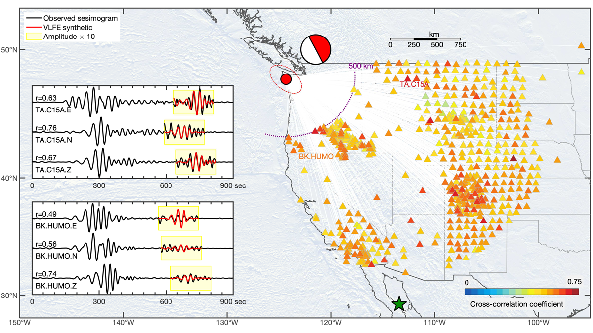
Continent-Scale Detection of Triggered Low Frequency Earthquakes
Very low frequency events in the gap zone of Cascadia illustrate how stress evolves on megathrusts, advancing our understanding of rupture dynamics.

Posted inResearch Spotlights
Potential of Leaking Modes to Reveal Underground Structure
Instead of waiting for earthquake waves to tell scientists about the structure of Earth’s interior, scientists can now use ambient noise from humans to “see” underground.

Posted inFeatures
Distributed Sensing and Machine Learning Hone Seismic Listening
Fiber-optic cables can provide a wealth of detailed data on subsurface vibrations from a wide range of sources. Machine learning offers a means to make sense of it all.
Posted inResearch Spotlights
ICON Principles Underused as a Natural Hazards Research Tool
Scientists identify barriers to and opportunities for applying integrated, connected, open, and networked research strategies to natural hazards studies.

Posted inNews
Searching for Earthquakes in the Ionosphere
Earthquakes may release bursts of electrical energy that can be felt in the ionosphere, kilometers above Earth. The theory remains controversial, though.
Posted inResearch Spotlights
Comparing Machine Learning Models for Earthquake Detection
A new study evaluated the performance of emerging deep learning models for earthquake detection, phase identification, and phase picking.
Posted inResearch Spotlights
Fiber-Optic Cables Can Produce High-Resolution Underground Maps
Telecom fiber repurposed as distributed acoustic sensing arrays can image near-surface structure and potentially improve seismic hazard mapping in urban areas.

Posted inNews
A Giant Impact Triggered Earthquakes for Thousands of Years
When an asteroid struck South Africa during the Precambrian, earthquakes rocked the region for millennia as Earth’s crust reequilibrated, new research reveals.