
Geodetic observations collected during back-to-back decadal research campaigns have revealed crucial new insights into the start–stop and slow-motion behavior of subduction zones.
earthquakes
Posted inEditors' Highlights
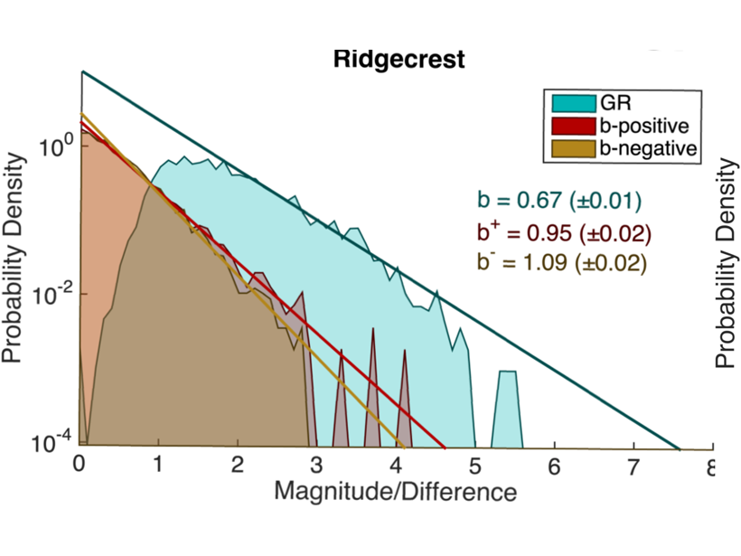
A New Robust Estimator of Earthquake Magnitude Distribution
The b-value, which describes the fraction of large versus small earthquakes, is less sensitive to transient changes in detection threshold and may improve the detection of precursory changes.

Posted inScience Updates
Discerning Structure and Seismic Hazards in the Sikkim Himalayas
A dense seismic network in operation since 2019 will provide new insights into the tectonics of seismically active Himalayan regions.

Posted inEditors' Highlights
When Will the Next Failure Be?
Unprecedented images of fracture networks in laboratory scale experiments mixed with machine learning algorithms help predict the timing of the next failure.
Posted inFeatures
Where Do People Fit into a Global Hazard Model?
By incorporating human systems, scientists are modeling geohazards with equity in mind.
Posted inScience Updates
Amateur Radio Operators Help Fill Earthquake Donut Holes
Ham radio networks gear up to provide real-time, on-the-ground information about earthquake shaking and damage when other communication pathways are knocked out of commission.
Posted inEditors' Highlights
Why are Earthquakes on the San Andreas Seasonally Modulated?
There is growing evidence that some earthquakes occur seasonally but also that water loading cannot explain these observations.
Posted inEditors' Highlights
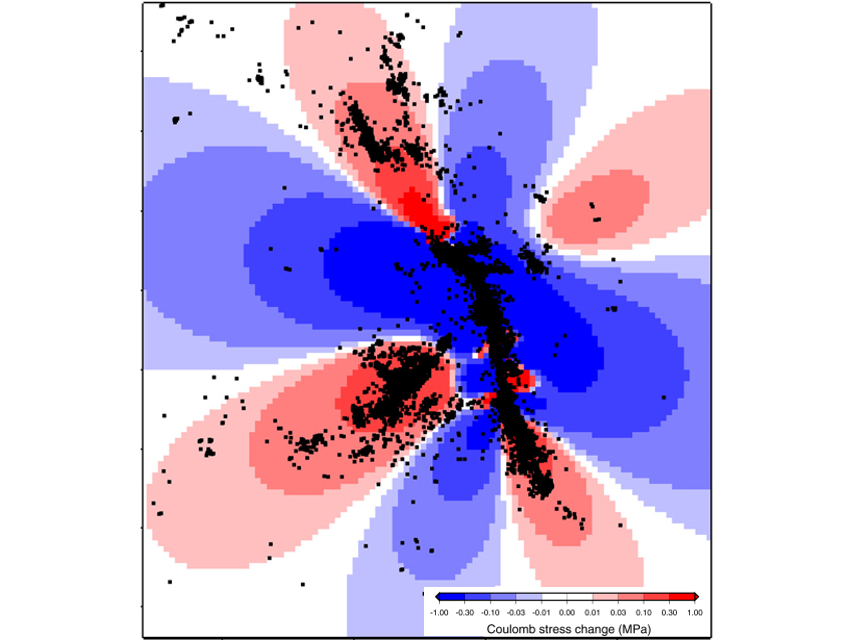
The Failure of Physics-Based Earthquake Forecasting Models
Spatial clustering of aftershocks explains why simple statistical models often outperform complex physics‐based earthquake forecasting models even if the physical mechanisms are correctly modeled.
Posted inResearch Spotlights
Earthquakes Can Acidify Groundwater
Fracturing during microearthquakes can cause groundwater pH drops. The change is temporary but can be equivalent to the difference between water and vinegar.

Posted inScience Updates
Using Earthquake Forensics to Study Subduction from Space
Researchers combined satellite geodetic measurements of surface motion with a new geophysical data inversion method to probe the Chilean subduction zone in the wake of the 2010 Maule earthquake.