
Improving our understanding of hazards posed by future large earthquakes on the Cascadia Subduction Zone requires advancements in the methods and sampling used to date and characterize past events.
earthquakes

Posted inFeatures
Ten Years on from the Quake That Shook the Nation’s Capital
A decade of study into the Virginia earthquake that damaged D.C. and reverberated up and down the Atlantic coast in 2011 has shed light on rare, but risk-laden, seismicity in eastern North America.

Posted inResearch Spotlights
First Report of Seismicity That Initiated in the Lower Mantle
A 4D back-projection method revealed that aftershocks of the 2015 earthquake beneath the Ogasawara (Bonin) Islands occurred as deep as about 750 kilometers.

Posted inEditors' Vox
Understanding and Anticipating Induced Seismicity
A new special collection in JGR: Solid Earth and Earth and Space Science seeks papers from across disciplines that provide insights into induced seismicity at different spatial and temporal scales.

Posted inEditors' Highlights
The Highs and the Lows of Megathrust Earthquakes
Why does low-frequency energy come from the shallow part of ruptures, and the high frequencies from deep?

Posted inResearch Spotlights
A New Method Produces Improved Surface Strain Rate Maps
The transdimensional Bayesian approach handles GPS data limitations better than existing methods and may assist future seismic hazard assessment studies.

Posted inNews
Tiny Kinks Record Ancient Quakes
As Earth ruptures, micas kink. These kink bands hide in rocks millions of years old, preserving evidence of past quakes.
Posted inEditors' Highlights
Good, Soon, and Cheap – Earthquake Early Warning by Smartphone
Fixed smartphone networks can provide robust early warning of earthquakes at far lower costs than traditional scientific arrays, which is an important consideration for regions with limited resources.
Posted inEditors' Highlights
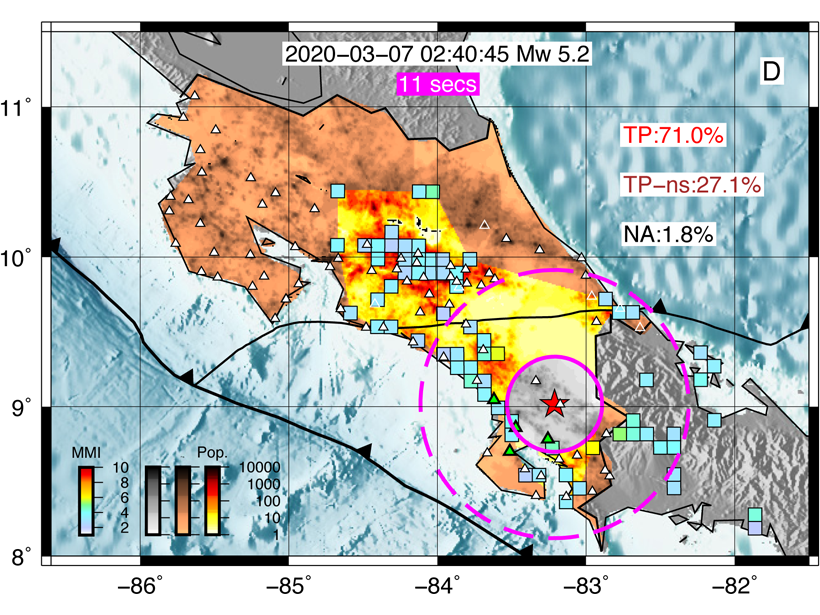
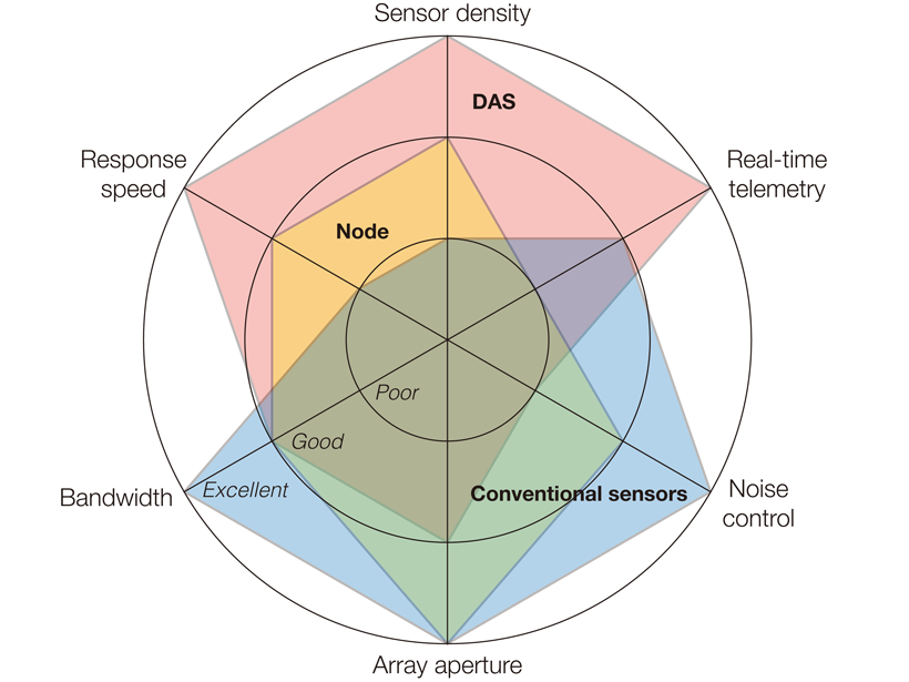
Aftershocks and Fiber Optics
Internet cables can be transformed into a string of dense seismic sensors, and this approach has now been shown to be highly useful for quickly monitoring seismicity after major earthquakes.

Posted inEditors' Vox
Learning from a Disastrous Megathrust Earthquake
Ten years of interdisciplinary studies since the disastrous Tohoku-oki earthquake have improved our knowledge of earthquake-cycle processes and hazard, but prediction of such events remains elusive.