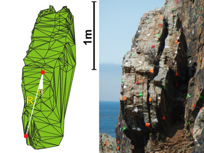
• About
  • Sections
  • Topics
    • Climate
    • Earth Science
    • Oceans
    • Space & Planets
    • Health & Ecosystems
    • Culture & Policy
    • Education & Careers
    • Opinions
  • Projects
    • ENGAGE
    • Editors’ Highlights
    • Editors’ Vox
    • Eos en Español
    • Eos 简体中文版
    • Print Archive
  • Science Policy Tracker
  • Blogs
    • Research & Developments
    • The Landslide Blog
  • Newsletter
  • Submit to Eos
  • AGU.org
  • Career Center
  • Join AGU
  • Give to AGU
  • About
  • Sections
  • Topics
    • Climate
    • Earth Science
    • Oceans
    • Space & Planets
    • Health & Ecosystems
    • Culture & Policy
    • Education & Careers
    • Opinions
  • Projects
    • ENGAGE
    • Editors’ Highlights
    • Editors’ Vox
    • Eos en Español
    • Eos 简体中文版
    • Print Archive
  • Science Policy Tracker
  • Blogs
    • Research & Developments
    • The Landslide Blog
  • Newsletter
  • Submit to Eos
Skip to content
  • AGU.org
  • Career Center
  • Join AGU
  • Give to AGU
Eos

Eos

Science News by AGU

Support Eos
Sign Up for Newsletter
  • About
  • Sections
  • Topics
    • Climate
    • Earth Science
    • Oceans
    • Space & Planets
    • Health & Ecosystems
    • Culture & Policy
    • Education & Careers
    • Opinions
  • Projects
    • ENGAGE
    • Editors’ Highlights
    • Editors’ Vox
    • Eos en Español
    • Eos 简体中文版
    • Print Archive
  • Science Policy Tracker
  • Blogs
    • Research & Developments
    • The Landslide Blog
  • Newsletter
  • Submit to Eos

earthquakes

Buckled blacktop road in front of a tree-lined street
Posted inNews

How Satellite Data Improve Earthquake Monitoring

Rachel Crowell, Science Writer by Rachel Crowell 19 July 201911 May 2022

Case studies from around the world illustrate the power of geodetic data in earthquake monitoring.

Geologist points at a rock feature in a cliff.
Posted inScience Updates

Addressing Cascadia Subduction Zone Great Earthquake Recurrence

by L. Staisch, M. Walton and Rob Witter 2 July 201918 January 2022

USGS Powell Center Cascadia Earthquake Hazards Working Group; Fort Collins, Colorado, 25–29 March 2019

Landslides after 2008 Wenchuan earthquake
Posted inEditors' Vox

Cascading Down the Mountain

by X. Fan, G. Scaringi, Q. Xu and R. Huang 24 June 201931 March 2023

Earthquakes in mountain ranges produce a cascade of geological disturbances and hazards, from enormous landslides to climate change.

Figure showing earthquake tremor locations
Posted inEditors' Highlights
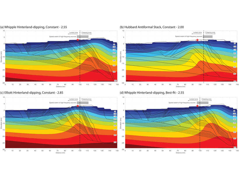
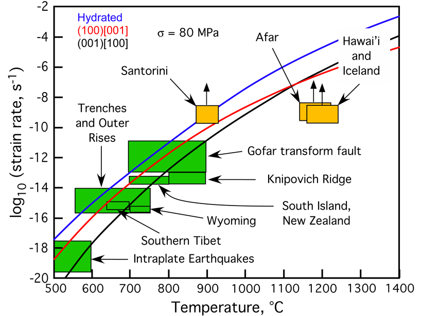
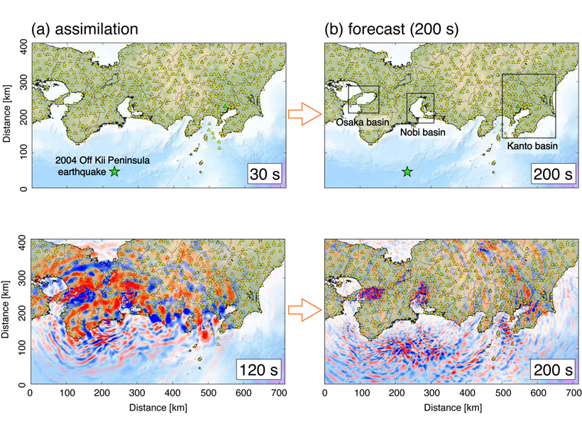
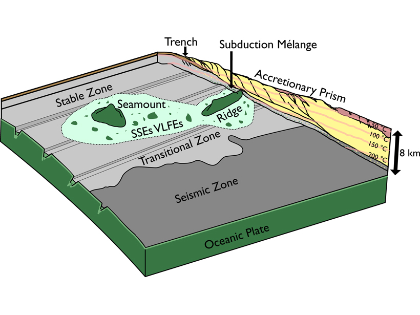
Shallow Low Frequency Tremors in Japan Trench

by G. P. Hayes 14 June 20196 December 2021

A new seafloor seismic network detected low-frequency tremor on the subduction zone interface offshore northern Japan, indicating regions of slow slip in close proximity to shallow megathrust events.

Distorted railway lines at the North Anatolian Fault due to the 1999 earthquake Aykut Barka
Posted inResearch Spotlights

Variations in Creep Along One of Earth’s Most Active Faults

by Terri Cook 6 June 201918 April 2022

Satellite-based radar images of motion along Turkey’s North Anatolian Fault are helping scientists understand when, where, and how creep occurs and its implications for seismic hazard.

Men working on a makeshift platform in front of a populated valley
Posted inNews

Afghanistan’s Blob Hunters

Lucas Joel by L. Joel 3 June 201919 October 2021

How a first-of-its-kind team of Afghan scientists and engineers helped make a monolithic discovery.

Close-up, black-and-white satellite image of the lunar landscape
Posted inNews

The Quaking, Shrinking Moon

Rachel Crowell, Science Writer by Rachel Crowell 30 May 201915 November 2022

New evidence suggests that the Moon may still be tectonically active.

A woman displays a Raspberry Shake seismometer in front of construction typical of many neighborhoods in Haiti.
Posted inScience Updates

Monitoring Haiti’s Quakes with Raspberry Shake

by E. Calais, D. Boisson, S. Symithe, R. Momplaisir, C. Prépetit, S. Ulysse, G. P. Etienne, F. Courboulex, A. Deschamps, T. Monfret, J.-P. Ampuero, B. M. de Lépinay, V. Clouard, R. Bossu, L. Fallou and E. Bertrand 17 May 20199 May 2023

A network of “personal seismometers” is intended to complement Haiti’s national seismic network to engage and inform residents about earthquake hazards and preparation.

A woman conducts experiments with a laptop in a lava field while volcanoes erupt in the distance.
Posted inNews

More Than 30,000 Earthquakes Trace the Movement of Magma

Katherine Kornei, Science Writer by Katherine Kornei 14 May 201927 October 2021

Seismometers near Iceland’s Bárðarbunga volcanic system pinpointed thousands of earthquakes in 2014–2015, revealing where molten rock was moving underground before any eruptions occurred.

A team of Afghan and U.S. scientists install a continuous GPS instrument
Posted inNews

The Blob Causing Earthquakes

Lucas Joel by L. Joel 10 May 201919 October 2021

Geophysicists discover that a “blob” of rock sinking into the mantle is the force triggering earthquakes in the Hindu Kush.

Posts pagination

Newer posts 1 … 26 27 28 29 30 … 42 Older posts
A view of a Washington, D.C., skyline from the Potomac River at night. The Lincoln Memorial (at left) and the Washington Monument (at right) are lit against a purple sky. Over the water of the Potomac appear the text “#AGU24 coverage from Eos.”

Features from AGU Publications

Research Spotlights

Strong Tides Speed Melting of Antarctic Ice Shelves

8 September 20258 September 2025
Editors' Highlights

Quantifying Predictability of the Middle Atmosphere

5 September 20255 September 2025
Editors' Vox

Experienced Researcher Book Publishing: Sharing Deep Expertise

3 September 202526 August 2025
Eos logo at left; AGU logo at right

About Eos
ENGAGE
Awards
Contact

Advertise
Submit
Career Center
Sitemap

© 2025 American Geophysical Union. All rights reserved Powered by Newspack