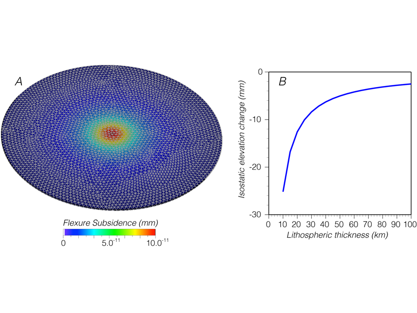
• About
  • Sections
  • Topics
    • Climate
    • Earth Science
    • Oceans
    • Space & Planets
    • Health & Ecosystems
    • Culture & Policy
    • Education & Careers
    • Opinions
  • Projects
    • ENGAGE
    • Editors’ Highlights
    • Editors’ Vox
    • Eos en Español
    • Eos 简体中文版
    • Print Archive
  • Blogs
    • Research & Developments
    • The Landslide Blog
  • Newsletter
  • Submit to Eos
  • AGU.org
  • Career Center
  • Join AGU
  • Give to AGU
  • About
  • Sections
  • Topics
    • Climate
    • Earth Science
    • Oceans
    • Space & Planets
    • Health & Ecosystems
    • Culture & Policy
    • Education & Careers
    • Opinions
  • Projects
    • ENGAGE
    • Editors’ Highlights
    • Editors’ Vox
    • Eos en Español
    • Eos 简体中文版
    • Print Archive
  • Blogs
    • Research & Developments
    • The Landslide Blog
  • Newsletter
  • Submit to Eos
Skip to content
  • AGU.org
  • Career Center
  • Join AGU
  • Give to AGU
Eos

Eos

Science News by AGU

Support Eos
Sign Up for Newsletter
  • About
  • Sections
  • Topics
    • Climate
    • Earth Science
    • Oceans
    • Space & Planets
    • Health & Ecosystems
    • Culture & Policy
    • Education & Careers
    • Opinions
  • Projects
    • ENGAGE
    • Editors’ Highlights
    • Editors’ Vox
    • Eos en Español
    • Eos 简体中文版
    • Print Archive
  • Blogs
    • Research & Developments
    • The Landslide Blog
  • Newsletter
  • Submit to Eos

earthquakes

Satellite view of the Salton Sea and surroundings in California
Posted inResearch Spotlights

Distant Quake Triggered Slow Slip on Southern San Andreas

by Terri Cook 23 September 201929 September 2021

A high-resolution map of surface displacements indicates that the 2017 Chiapas earthquake caused substantial creep along a segment of the San Andreas Fault, located 3,000 kilometers away.

Aerial photo of subsidence craters in the desert
Posted inNews

Nuclear Bomb or Earthquake? Explosions Reveal the Differences

Katherine Kornei, Science Writer by Katherine Kornei 9 September 201910 March 2023

A series of controlled chemical detonations in the Nevada desert is helping researchers discern between ground shaking caused by nuclear explosions and earthquakes.

Ranch near Anza, Calif.
Posted inNews

Wind-Triggered Ground Shaking Masks Microseismicity

Katherine Kornei, Science Writer by Katherine Kornei 20 August 201913 January 2022

Ground motion caused by gusts of wind can drown out signals from the smallest earthquakes, potentially confusing earthquake detection algorithms.

Photo of fracking rigs along a dirt road
Posted inNews

Sinking Wastewater Triggers Deeper, Stronger Earthquakes

Mary Caperton Morton, Science Writer by Mary Caperton Morton 16 August 201916 February 2022

The effects of pumping wastewater from oil and gas extractions may last a decade or more after the injections stop.

Diagram showing how groundwater disappears into crustal ruptures formed during an earthquake
Posted inEditors' Highlights

Groundwater Drawn Downward After Kumamoto Quake

by Marc F. P. Bierkens 14 August 20195 December 2022

A unique set of high-frequency groundwater level monitoring reveals a loss of approximately ten million cubic meters of groundwater after a major earthquake.

Photo of a destroyed seawall with Japanese writing
Posted inNews

Earthquakes Shake Up Groundwater Systems

Mary Caperton Morton, Science Writer by Mary Caperton Morton 13 August 201911 May 2022

Increased permeability temporarily boosts water flow.

Buckled blacktop road in front of a tree-lined street
Posted inNews

How Satellite Data Improve Earthquake Monitoring

Rachel Crowell, Science Writer by Rachel Crowell 19 July 201911 May 2022

Case studies from around the world illustrate the power of geodetic data in earthquake monitoring.

Geologist points at a rock feature in a cliff.
Posted inScience Updates

Addressing Cascadia Subduction Zone Great Earthquake Recurrence

by L. Staisch, M. Walton and Rob Witter 2 July 201918 January 2022

USGS Powell Center Cascadia Earthquake Hazards Working Group; Fort Collins, Colorado, 25–29 March 2019

Landslides after 2008 Wenchuan earthquake
Posted inEditors' Vox

Cascading Down the Mountain

by X. Fan, G. Scaringi, Q. Xu and R. Huang 24 June 201931 March 2023

Earthquakes in mountain ranges produce a cascade of geological disturbances and hazards, from enormous landslides to climate change.

Figure showing earthquake tremor locations
Posted inEditors' Highlights

Shallow Low Frequency Tremors in Japan Trench

by G. P. Hayes 14 June 20196 December 2021

A new seafloor seismic network detected low-frequency tremor on the subduction zone interface offshore northern Japan, indicating regions of slow slip in close proximity to shallow megathrust events.

Posts pagination

Newer posts 1 … 25 26 27 28 29 … 42 Older posts
A view of a Washington, D.C., skyline from the Potomac River at night. The Lincoln Memorial (at left) and the Washington Monument (at right) are lit against a purple sky. Over the water of the Potomac appear the text “#AGU24 coverage from Eos.”

Features from AGU Publications

Research Spotlights

Arctic Rivers Trade Inorganic Nitrogen for Organic

6 August 20256 August 2025
Editors' Highlights

Nearly 94 Million Boulders Mapped on the Moon Using Deep Learning

6 August 20255 August 2025
Editors' Vox

Early-Career Book Publishing: Growing Roots as Scholars

6 August 202530 July 2025
Eos logo at left; AGU logo at right

About Eos
ENGAGE
Awards
Contact

Advertise
Submit
Career Center
Sitemap

© 2025 American Geophysical Union. All rights reserved Powered by Newspack