• About
  • Special Reports
  • Topics
    • Climate
    • Earth Science
    • Oceans
    • Space & Planets
    • Health & Ecosystems
    • Culture & Policy
    • Education & Careers
    • Opinions
  • Projects
    • Postcards From the Field
    • ENGAGE
    • Editors’ Highlights
    • Editors’ Vox
    • Eos en Español
    • Eos 简体中文版
    • Print Archive: 2015–2025
  • Policy Tracker
  • Blogs
    • Research & Developments
    • The Landslide Blog
  • Newsletter
  • Submit to Eos
  • AGU.org
  • Career Center
  • Join AGU
  • Give to AGU
  • About
  • Special Reports
  • Topics
    • Climate
    • Earth Science
    • Oceans
    • Space & Planets
    • Health & Ecosystems
    • Culture & Policy
    • Education & Careers
    • Opinions
  • Projects
    • Postcards From the Field
    • ENGAGE
    • Editors’ Highlights
    • Editors’ Vox
    • Eos en Español
    • Eos 简体中文版
    • Print Archive: 2015–2025
  • Policy Tracker
  • Blogs
    • Research & Developments
    • The Landslide Blog
  • Newsletter
  • Submit to Eos
Skip to content
  • AGU.org
  • Career Center
  • Join AGU
  • Give to AGU
Eos

Eos

Science News by AGU

Support Eos
Sign Up for Newsletter
  • About
  • Special Reports
  • Topics
    • Climate
    • Earth Science
    • Oceans
    • Space & Planets
    • Health & Ecosystems
    • Culture & Policy
    • Education & Careers
    • Opinions
  • Projects
    • Postcards From the Field
    • ENGAGE
    • Editors’ Highlights
    • Editors’ Vox
    • Eos en Español
    • Eos 简体中文版
    • Print Archive: 2015–2025
  • Policy Tracker
  • Blogs
    • Research & Developments
    • The Landslide Blog
  • Newsletter
  • Submit to Eos

faults

Mountains and blue sky in the background, with green pastures in the foreground. A road extends from the foreground toward the mountains.
Posted inResearch Spotlights

New Tectonic Plate Model Could Improve Earthquake Risk Assessment

by Morgan Rehnberg 21 December 202218 January 2023

A new model of tectonic plates in New Zealand may identify areas of increased earthquake likelihood.

Two maps showing the location and main tectonic features of the 1987 Edgecumbe earthquake.
Posted inEditors' Highlights

Coseismic Displacement of 1987 Earthquake from Aerial Images

by Daniel Melnick 8 December 20226 December 2022

Differencing digital surface topography models constructed from historical aerial photographs reveal the coseismic surface displacement field of the 1987 earthquake in northern New Zealand.

白雪覆盖的山峰排列在青藏高原的南部边缘。
Posted inResearch Spotlights

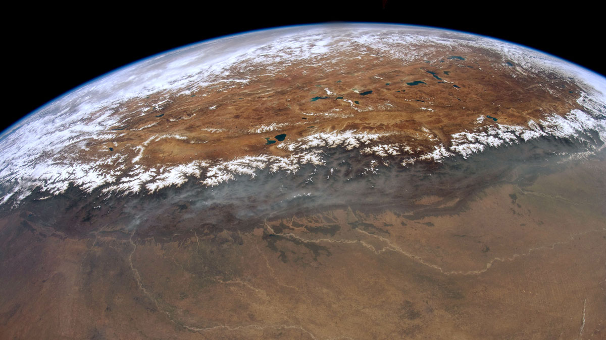
研究揭示尼泊尔西部喜马拉雅港湾状地形的形成

Sarah Derouin, Science Writer by Sarah Derouin 19 October 202219 October 2022

研究人员通过热运动学研究发现,沿着板块汇聚界面大型逆冲断层在中下部地壳深处的地壳物质堆叠塑造了高原的生长和区域水系的发育。

Two block diagrams that show how the George Sound shear zone (GSSZ) grew through the crust in space and time.
Posted inEditors' Highlights

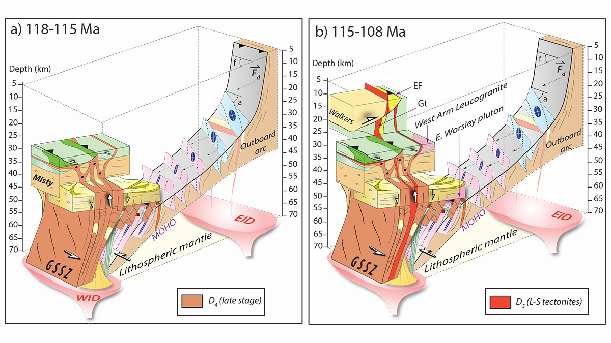
Feedbacks Between Deformation and Magmatism as Shear Zones Grow

by Alexis Ault 29 September 202228 September 2022

New research reveals how the presence and absence of magmatism governs how shear zones initiate, grow, and reactivate to connect lower and upper crustal deformation.

Snow-covered peaks line the southern edge of the Tibetan plateau.
Posted inResearch Spotlights

Uncovering the Formation of the Western Nepal Embayment

Sarah Derouin, Science Writer by Sarah Derouin 24 August 202219 October 2022

Using thermokinematics, researchers have found that crustal accretion along the megathrust at mid-lower crustal depths shapes plateau growth and regional drainage development.

Aerial photo of San Andreas Fault.
Posted inResearch Spotlights

How Land Deformation Occurs When Fault Sections Creep

Sarah Derouin, Science Writer by Sarah Derouin 1 July 20221 July 2022

Using a physical experiment, researchers show how off-fault deformation occurs along strike-slip faults with different types of motion.

A street in Guthrie, Okla.
Posted inResearch Spotlights

Understanding Earthquakes Triggered by Wastewater Injection

Sarah Stanley, Science Writer by Sarah Stanley 27 June 202227 June 2022

A deep dive into a 2015 Oklahoma earthquake reveals new insights into the dynamics of quakes induced by wastewater injection, and could help inform future earthquake hazard modeling.

例如断层蠕变正在使加州大学伯克利分校的体育场墙壁产生变形。
Posted inResearch Spotlights

地震建模专家联合行动比较和改进模型编码

Sarah Stanley, Science Writer by Sarah Stanley 24 June 202224 June 2022

国际社会推动的努力为断层滑动模拟提供了信心,同时突出了其中的关键差异。

Photo of rock outcrop showing foliation-parallel quartz veins.
Posted inEditors' Vox

The Kinetics of the Seismic Cycle

by Randolph T. Williams and Åke Fagereng 7 June 202214 September 2022

Large earthquakes are necessarily punctuated by some degree of strength recovery, such as “fault healing”, but does quartz cementation during fluid-fault interactions facilitate that process?

Gradual fault creep can be seen deforming the walls of this stadium at the University of California, Berkeley.
Posted inResearch Spotlights

Earthquake Modelers Unite to Compare and Improve Code

Sarah Stanley, Science Writer by Sarah Stanley 2 May 202224 June 2022

International community–driven efforts lend confidence to fault-slip simulations while highlighting key discrepancies.

Posts pagination

Newer posts 1 … 7 8 9 10 11 … 19 Older posts
Over a dark blue-green square appear the words Special Report: The State of the Science 1 Year On.

Features from AGU Publications

Research Spotlights

As Wildfires Increase in the West, So Does Suppression Spending

10 June 202610 June 2026
Editors' Highlights

Where Methane is Emitted Matters for Global Burden

18 June 202616 June 2026
Editors' Vox

Small-Scale Indian Ocean Dynamics Underpin Marine Ecology and Climate

4 June 20263 June 2026
Eos logo at left; AGU logo at right

About Eos
ENGAGE
Awards
Contact

Advertise
Submit
Career Center
Sitemap

© 2026 American Geophysical Union. All rights reserved Powered by Newspack