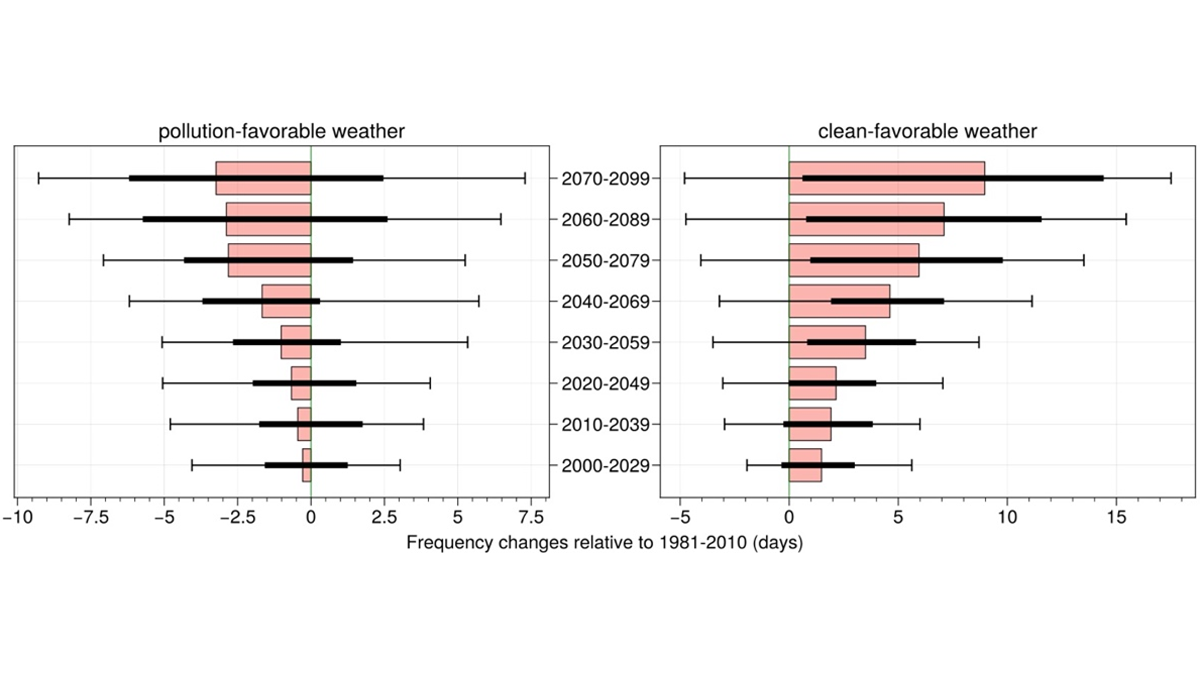
• About
  • Sections
  • Topics
    • Climate
    • Earth Science
    • Oceans
    • Space & Planets
    • Health & Ecosystems
    • Culture & Policy
    • Education & Careers
    • Opinions
  • Projects
    • ENGAGE
    • Editors’ Highlights
    • Editors’ Vox
    • Eos en Español
    • Eos 简体中文版
    • Print Archive
  • Blogs
    • Research & Developments
    • The Landslide Blog
  • Newsletter
  • Submit to Eos
  • AGU.org
  • Career Center
  • Join AGU
  • Give to AGU
  • About
  • Sections
  • Topics
    • Climate
    • Earth Science
    • Oceans
    • Space & Planets
    • Health & Ecosystems
    • Culture & Policy
    • Education & Careers
    • Opinions
  • Projects
    • ENGAGE
    • Editors’ Highlights
    • Editors’ Vox
    • Eos en Español
    • Eos 简体中文版
    • Print Archive
  • Blogs
    • Research & Developments
    • The Landslide Blog
  • Newsletter
  • Submit to Eos
Skip to content
  • AGU.org
  • Career Center
  • Join AGU
  • Give to AGU
Eos

Eos

Science News by AGU

Support Eos
Sign Up for Newsletter
  • About
  • Sections
  • Topics
    • Climate
    • Earth Science
    • Oceans
    • Space & Planets
    • Health & Ecosystems
    • Culture & Policy
    • Education & Careers
    • Opinions
  • Projects
    • ENGAGE
    • Editors’ Highlights
    • Editors’ Vox
    • Eos en Español
    • Eos 简体中文版
    • Print Archive
  • Blogs
    • Research & Developments
    • The Landslide Blog
  • Newsletter
  • Submit to Eos

Geophysical Research Letters

Visit the journal.

The moon appears at the top of the layers of atmosphere above the dark Earth. The orange-red glow is Earth’s troposphere, and the brown transitional layer is the tropopause.
Posted inResearch Spotlights

Convective Transport Explains “Missing” Ice near the Tropical Tropopause

by David Shultz 10 May 202129 March 2022

Spaceborne lidar shows that more ice than expected is leaving the tropical tropopause layer in the atmosphere.

Plot showing smoke from California observed over Europe by lidar.
Posted inEditors' Highlights

The Promise of Spaceborne High Spectral Resolution Lidar

by C. Cappa 7 May 202126 October 2021

New spaceborne high spectral resolution lidar measurements provide a new view of global aerosols.

An image of Naito Parkway in Portland, Ore., during the COVID-19 pandemic
Posted inResearch Spotlights

Did the Drop in COVID-Related Emissions Affect the Climate?

Kate Wheeling, freelance science writer by Kate Wheeling 4 May 202113 March 2023

Global emissions dropped markedly in 2020, due in large part to lockdowns that slowed economic and social activity, but the climate likely won’t be noticeably affected.

Map showing moisture contribution anomalies during the 2005 drought quantified as the deviation from long-term average.
Posted inEditors' Highlights

Upwind Forest Buffers Rondonia Cropland Against Regional Drought

by Guiling Wang 27 April 20216 December 2021

During severe Amazonia droughts when oceanic supply of moisture failed, the magnitude of rainfall reduction over Rondonia was moderated by enhanced moisture supply from upwind forests.

Imagen de satélite mostrando el huracán Dorian sobre las Bahamas en 2019
Posted inResearch Spotlights

Descifrando las causas de la actividad de los huracanes en el pasado

Aaron Sidder, freelance science writer by Aaron Sidder 7 April 202126 October 2022

Registros individuales de paleohuracanes extraídos de los sedimentos de islas azotadas por tormentas no muestran una clara influencia del clima en la frecuencia de los huracanes en el último milenio.

夜晚,火焰和滚滚浓烟从树上升起。
Posted inResearch Spotlights

多发野火可作为资源压力指标

Kate Wheeling, freelance science writer by Kate Wheeling 18 March 202113 February 2023

摘要:研究人员发现,在美国西部,同步多发火灾风险的天数与资源分配之间存在着很强的相关性。

A rift in Antarctica’s Amery Ice Shelf
Posted inResearch Spotlights

Satellite Captures Detaching Iceberg in Near-Real Time

Aaron Sidder, freelance science writer by Aaron Sidder 10 March 202128 July 2022

NASA’s ICESat-2 satellite recorded the cleaving of a 315-billion-ton iceberg from Amery Ice Shelf in 2019, as well as years of subtle cracking and splitting prior to the calving event.

Yangtze River
Posted inResearch Spotlights

Researchers Home in on the Age of the Yangtze River

Joshua Learn, Science Writer by Joshua Rapp Learn 10 March 202126 January 2023

Findings on the river’s age also have implications for past landscape change in Asia.

Xray tomograms taken at two times which show fractures and pores within solid rock.
Posted inEditors' Highlights

When Will the Next Failure Be?

by G. A. Prieto 5 March 202127 January 2023

Unprecedented images of fracture networks in laboratory scale experiments mixed with machine learning algorithms help predict the timing of the next failure.

Flames and billowing smoke rise from trees at night.
Posted inResearch Spotlights

Widespread Wildfire as a Proxy for Resource Strain

Kate Wheeling, freelance science writer by Kate Wheeling 4 March 20214 October 2021

Researchers have found a strong correlation between the number of days with widespread, synchronous fire danger and resource allocation across the western United States.

Posts pagination

Newer posts 1 … 16 17 18 19 20 … 58 Older posts
A view of a Washington, D.C., skyline from the Potomac River at night. The Lincoln Memorial (at left) and the Washington Monument (at right) are lit against a purple sky. Over the water of the Potomac appear the text “#AGU24 coverage from Eos.”

Features from AGU Publications

Research Spotlights

More Bubbles Means More Variation in Ocean Carbon Storage

8 July 20258 July 2025
Editors' Highlights

Scientists Face Limitations Accessing Seafloor Information

9 July 20258 July 2025
Editors' Vox

Water Tracks: The Veins of Thawing Landscapes

25 June 202525 June 2025
Eos logo at left; AGU logo at right

About Eos
ENGAGE
Awards
Contact

Advertise
Submit
Career Center
Sitemap

© 2025 American Geophysical Union. All rights reserved Powered by Newspack