The Landslide Blog is written by Dave Petley, who is widely recognized as a world leader in the study and management of landslides. Information is emerging about the 24 June 2024 landslide at Eagle Mine in Yukon, Canada. Northern Miner has a video taken from an aircraft flying over the site that is worth a […]
Hazards & Disasters

Posted inThe Landslide Blog
The possible causes of the deadly 21 June 2024 Sorte debris flow in Switzerland
The Landslide Blog is written by Dave Petley, who is widely recognized as a world leader in the study and management of landslides. The Federal Office of Topography in Switzerland has collected and published online aerial imagery of the site of the deadly 21 June 2024 debris flow in Switzerland, which killed three people. The […]
Posted inEditors' Highlights
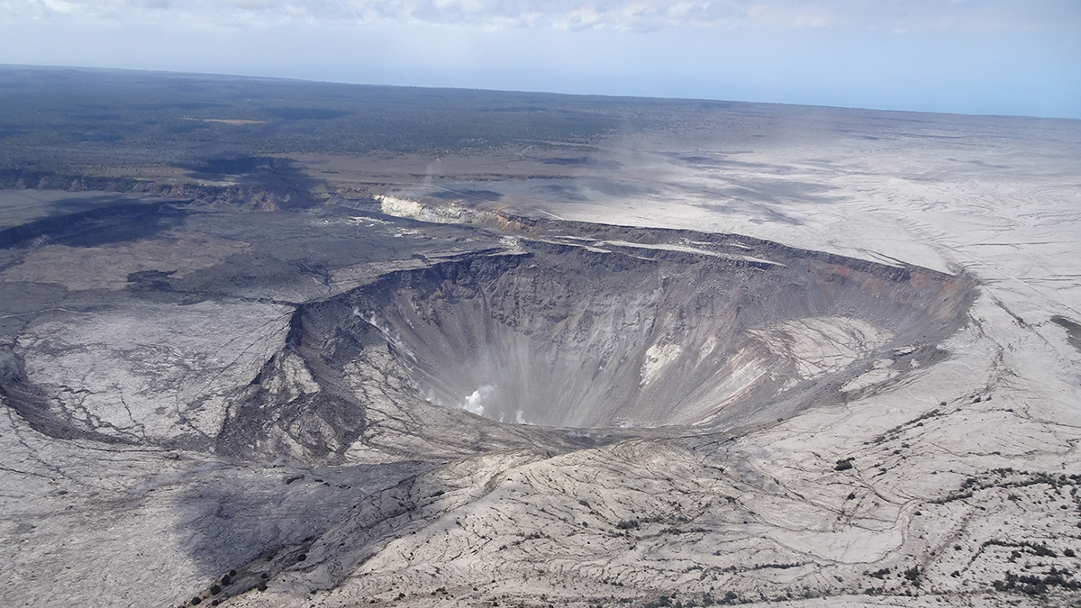
Caldera Collapse as a Natural Example of Rock Friction
Recurrent slips on the caldera wall of the Kīlauea Volcano are a natural experiment not only to understand the mechanics of caldera formation but also to gain more insights into fault friction.

Posted inThe Landslide Blog
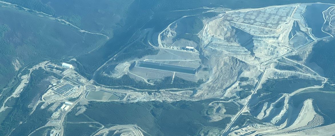
A major landslide at a heap leach pad at Eagle Gold Mine in the Yukon, Canada
The Landslide Blog is written by Dave Petley, who is widely recognized as a world leader in the study and management of landslides. In a short statement on its website yesterday, Victoria Gold (“a mining company focused on the Yukon”) confirmed that “the heap leach pad (“HLP”) at the Eagle Gold Mine in Yukon experienced […]

Posted inEditors' Highlights
Dual Tsunami Generation from Atmospheric and Oceanic Sources
The 2022 Tonga volcanic eruption generated waves that propagated across the Pacific Ocean. A new analysis of sea level measurements is used to dissect the difference in wave components from two sources.

Posted inThe Landslide Blog
The 21 June 2024 landslide at Sorte in Switzerland
The Landslide Blog is written by Dave Petley, who is widely recognized as a world leader in the study and management of landslides. On 21 June 2024, a large landslide struck Sorte, a small hamlet in the Misox Valley of Switzerland, triggered by extremely intense rainfall. At the time of writing it is believed that […]

Posted inThe Landslide Blog
A landslide emergency at Longiarù in northern Italy
The Landslide Blog is written by Dave Petley, who is widely recognized as a world leader in the study and management of landslides. In the Dolomite region of northern Italy, an interesting landslide emergency is under way. The location is Longiarù, a village located in San Martino in Badia. So far, 56 buildings, mostly houses, […]

Posted inThe Landslide Blog
Landslides triggered by an extreme rainfall event on 4 July 2023 in Wanzhou, China
The Landslide Blog is written by Dave Petley, who is widely recognized as a world leader in the study and management of landslides. In the last few days, China has suffered multiple landslides triggered by heavy rainfall, with reports of fatalities. It is often difficult to get high quality information about these events in China […]
Posted inThe Landslide Blog
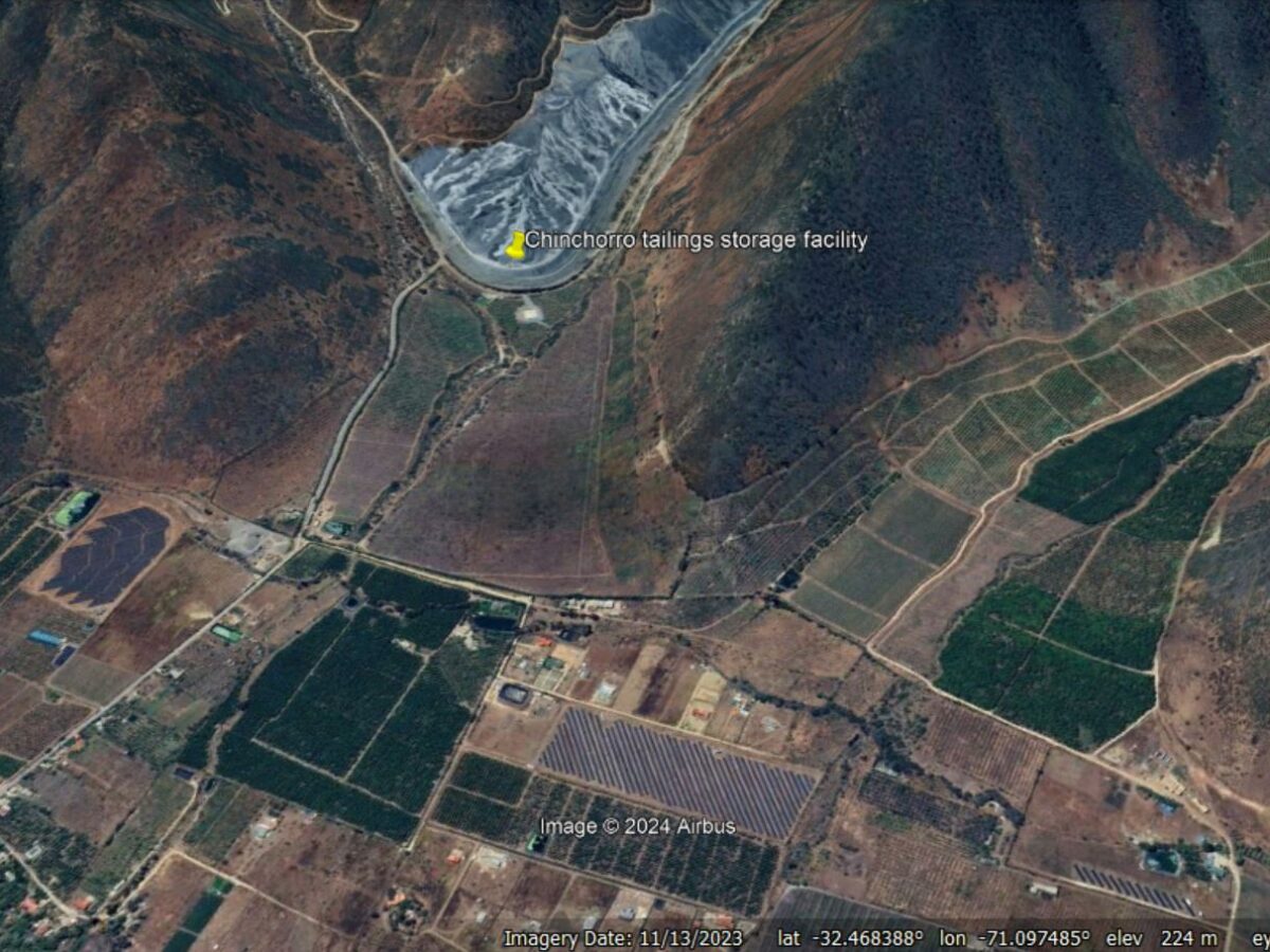
The 13 June 2024 tailings dam failure at the Chinchorro TSF at Peñablanca in Chile
The Landslide Blog is written by Dave Petley, who is widely recognized as a world leader in the study and management of landslides. At about 8 pm on 13 June 2024, a failure occurred in the embankment wall of the Chinchorro tailings storage facility, close to the village of Peñablanca, near the town of Cabildo […]

Posted inThe Landslide Blog
The causes of the 8 January 2022 fatal rock topple at Furnas Reservoir in Brazil
The Landslide Blog is written by Dave Petley, who is widely recognized as a world leader in the study and management of landslides. On 8 January 2022, a large rock topple occurred on the banks of the Furnas Reservoir in Brazil. This event, which I wrote about at the time, was captured on a series […]