• About
  • Special Reports
  • Topics
    • Climate
    • Earth Science
    • Oceans
    • Space & Planets
    • Health & Ecosystems
    • Culture & Policy
    • Education & Careers
    • Opinions
  • Projects
    • Postcards From the Field
    • ENGAGE
    • Editors’ Highlights
    • Editors’ Vox
    • Eos en Español
    • Eos 简体中文版
    • Print Archive: 2015–2025
  • Policy Tracker
  • Blogs
    • Research & Developments
    • The Landslide Blog
  • Newsletter
  • Submit to Eos
  • AGU.org
  • Career Center
  • Join AGU
  • Give to AGU
  • About
  • Special Reports
  • Topics
    • Climate
    • Earth Science
    • Oceans
    • Space & Planets
    • Health & Ecosystems
    • Culture & Policy
    • Education & Careers
    • Opinions
  • Projects
    • Postcards From the Field
    • ENGAGE
    • Editors’ Highlights
    • Editors’ Vox
    • Eos en Español
    • Eos 简体中文版
    • Print Archive: 2015–2025
  • Policy Tracker
  • Blogs
    • Research & Developments
    • The Landslide Blog
  • Newsletter
  • Submit to Eos
Skip to content
  • AGU.org
  • Career Center
  • Join AGU
  • Give to AGU
Eos

Eos

Science News by AGU

Support Eos
Sign Up for Newsletter
  • About
  • Special Reports
  • Topics
    • Climate
    • Earth Science
    • Oceans
    • Space & Planets
    • Health & Ecosystems
    • Culture & Policy
    • Education & Careers
    • Opinions
  • Projects
    • Postcards From the Field
    • ENGAGE
    • Editors’ Highlights
    • Editors’ Vox
    • Eos en Español
    • Eos 简体中文版
    • Print Archive: 2015–2025
  • Policy Tracker
  • Blogs
    • Research & Developments
    • The Landslide Blog
  • Newsletter
  • Submit to Eos

land use

Panorama of a wetland
Posted inNews

Mapping Wetland Loss Across Three Centuries

by Carolyn Wilke 10 March 202310 March 2023

Millions of square kilometers of wetlands have been drained or converted to make room for crops, pastures, or development. In some places, up to 80% are gone.

Satellite images of the Yangtze River in 1999 and 2010, showing a radical reduction in suspended sediment
Posted inNews

Satellites Show Magnitude of Human Influence on River Sediment Flux

by Mohammed El-Said 12 July 20228 September 2022

Dam-building has decreased the amount of sediment transported by rivers, while land use changes have increased the amount.

Palm swamp in Peru
Posted inNews

Peeking at Peatlands: Satellite Data Fuel New Findings

Adityarup Chakravorty, freelance science writer by Adityarup Chakravorty 15 June 202229 June 2022

Researchers are combining hard-to-get field measurements with satellite imagery to gain new insight into where peatlands are and how they work.

Mangrove forest
Posted inNews

After a Hurricane, Coastal Systems Draw a Line in the Sand

by J. Besl 13 April 202213 April 2022

A new study finds nature can’t have it both ways: On the basis of thousands of case studies from dozens of hurricanes, there’s always a trade-off between resistance and resilience.

Increased rainfall and floods threaten the urban landscape of Abidjan, Ivory Coast.
Posted inENGAGE, News

Deforestation Is Flooding West African Coasts

by Humberto Basilio 7 February 202227 March 2023

The lack of trees is contributing to increased rainfall along the coast of southwest Africa, where communities are already vulnerable to flash flooding.

Posted inEditors' Highlights

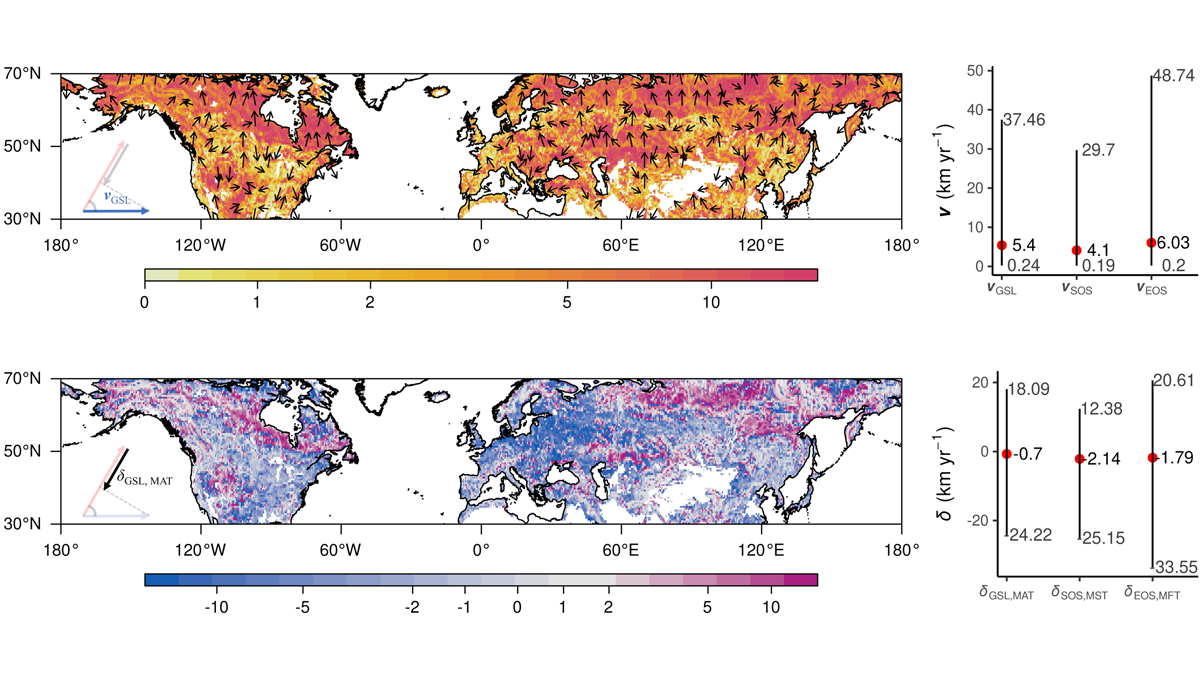
The Flowers that Bloom in the Spring (but Later)

by David S. Schimel 31 December 20217 February 2023

Mismatch between the pace of climate change and crop phenology may signal a new challenge for climate change adaptation.

Two crimson-fronted cardinals perch on a leafy branch.
Posted inNews

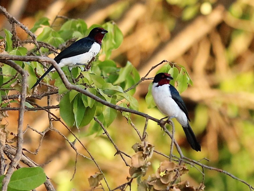
Birds Are Getting Caged In at Brazil’s Savanna

by Meghie Rodrigues 11 August 202021 December 2023

Deforestation and climate change threaten life in the Cerrado. A new study shows how few places there are left to go.

The Sun sets over Lake Shinji in western Japan
Posted inResearch Spotlights

How Land Use Affects Nutrient Pollution in a Changing Climate

Elizabeth Thompson by Elizabeth Thompson 4 September 201916 February 2022

As heavy rain falls more frequently, the land alongside a river has a greater effect on the waterway’s nutrient levels—for better or worse.

Flood victims are transported in an inflated raft as rain falls.
Posted inNews

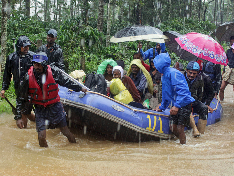
Devastating Floods Hit India for the Second Year in a Row

Jenessa Duncombe, Staff Writer by Jenessa Duncombe 26 August 20198 March 2022

The deadly floods raise questions of land use and extreme precipitation trends.

A series of petroglyphs of animal, human, and plant images on a cliff wall
Posted inNews

European Contact with the Americas May Have Triggered Global Cooling

Mary Caperton Morton, Science Writer by Mary Caperton Morton 8 April 20199 September 2024

The loss of precontact agricultural communities to genocide and disease may have led to massive reforestation, a dip in carbon dioxide, and one of the coldest snaps of the Little Ice Age.

Posts pagination

Newer posts 1 2 3 4 Older posts
Over a dark blue-green square appear the words Special Report: The State of the Science 1 Year On.

Features from AGU Publications

Research Spotlights

Improving Eddy Tower Evapotranspiration Estimates

20 May 202620 May 2026
Editors' Highlights

Recycled Rocks Reveal Subduction Zone Dynamics Off Baja California

21 May 202621 May 2026
Editors' Vox

The Impact of Advocacy: American Geophysical Union’s Days of Action

14 May 202613 May 2026
Eos logo at left; AGU logo at right

About Eos
ENGAGE
Awards
Contact

Advertise
Submit
Career Center
Sitemap

© 2026 American Geophysical Union. All rights reserved Powered by Newspack