
Peatlands—waterlogged environments where a lack of oxygen slows down decomposition and leads to the accumulation of large amounts of organic material—are among the most efficient carbon sinks on the planet. They occupy only about 3% of Earth’s land surface, yet they hold between 30% and 44% of global soil carbon.
Yet the same conditions that make peatlands such efficient carbon sinks have also made it difficult for researchers to access and study these ecosystems. In fact, according to the Global Peatlands Initiative, “there is significant uncertainty around peatlands because their extent, status and dynamics have never been globally mapped with sufficient accuracy.”
Satellite data can provide one way to overcome the challenges of having to do extensive fieldwork in peatlands and the lack of historical data from these areas. Two recent studies on tropical peatlands took advantage of the plethora of available satellite data. A study in Science Advances used historical satellite data to show that as tropical peatlands in northwest Borneo were converted to other uses, coastal waters in the area received large inputs of dissolved organic carbon. Halfway across the world, researchers used satellite data to generate extensive, detailed maps of tropical peatlands in the Peruvian Amazon. That study, in Nature Geoscience, shows that tropical peatlands in Peru are still mostly intact but are starting to be affected by land use changes due to mining, agriculture, and urban development.
As Peatlands Fall, Coastal Carbon Levels Rise
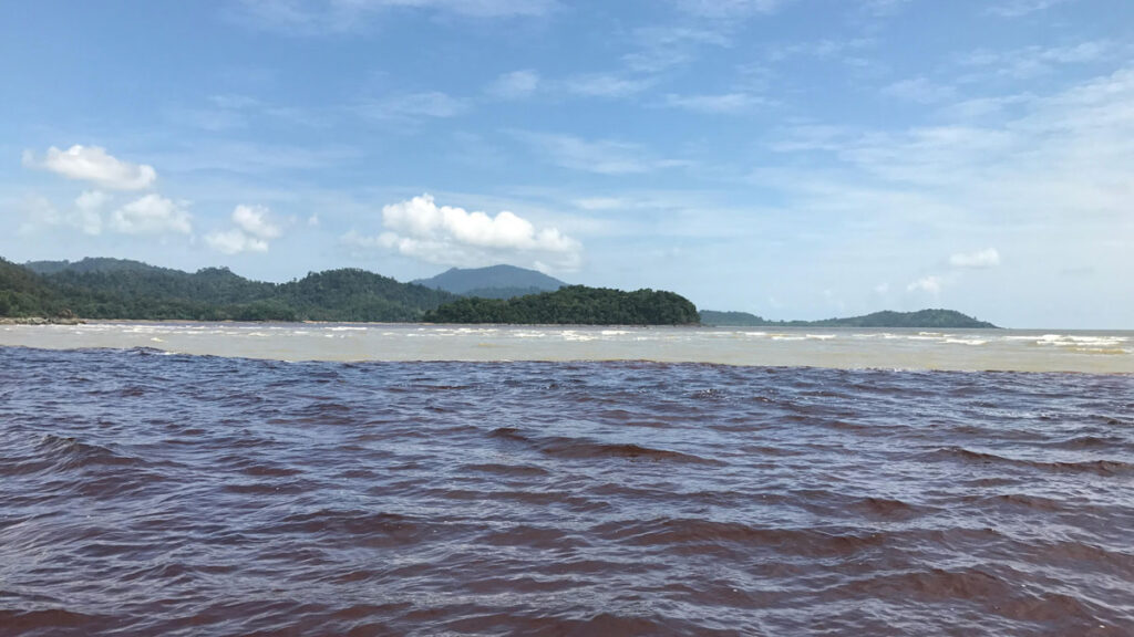
Over the past few decades, much of the peatlands of Southeast Asia have been lost, with most being converted to farmland or plantations for palm oil or wood pulp. When peatlands are drained, their vast stores of carbon are released into the environment. Some of this carbon drains to coastal waters, but details have been difficult to determine, according to Patrick Martin, senior author of the study in Science Advances and a biogeochemist at Nanyang Technological University in Singapore. And in this case, the devil may well be in the details.
“Carbon from converted peatlands is a significant source of terrestrial carbon entering the ocean, and we still don’t have a very good understanding of what happens to that carbon.”
“Carbon from converted peatlands is a significant source of terrestrial carbon entering the ocean, and we still don’t have a very good understanding of what happens to that carbon,” Martin said. It’s important to know because terrestrial carbon can have large downstream effects in coastal waters—it could contribute to ocean acidification, for instance. Also, “terrestrial dissolved carbon is relatively rich in chromophoric or colored organic carbon, which absorbs light,” Martin said. “That can alter the underwater light environment, which can affect many organisms.”
There are no long-term data on carbon outflow from peatlands into the coastal waters of Southeast Asia. Enter satellite data. “A big advantage of satellite data is that you can look back in time to before we have any field measurements,” said Nivedita Sanwlani, lead author of the study. Sanwlani is a research fellow at the Environment and Water Research Institute, Nanyang Technological University.
Sanwlani, Martin, and their colleagues analyzed satellite data on light reflected from the ocean surface. The wavelength of the reflected light (called reflectance) can provide valuable clues about the amount of dissolved organic carbon in that area. The researchers combined satellite data and field observations from 41 different areas in the study area off the northwestern (Malaysian) coast of Borneo to model changes in levels of dissolved organic carbon along the coast. They found that concentrations of dissolved organic carbon increased dramatically between 2002 and 2021. This period coincided with the loss of almost 70% of regional peatlands to other land use patterns.
“It’s pretty damning evidence that peatland conversion can affect coastal areas,” said Paul Aplin, a geographer at Mary Immaculate College, Ireland, who has worked extensively with Southeast Asian peatlands but was not involved in the study. “It makes sense to me that the process of draining peatlands and converting them into other land use will literally have a downstream effect.”
A Satellite’s-Eye View Maps Peatlands in Peru
Halfway across the world in Peru, Adam Hastie hopes that accurately mapping the peatlands of the Peruvian Amazon means they are actively managed and conserved. “If you want to make good decisions on managing and protecting tropical peatlands, you need relatively accurate and high-resolution maps that tell you the extent of the peatlands, the depth of the peat, and the carbon density,” Hastie said. He is the lead author of the Nature Geoscience study and a geoscientist at the University of Edinburgh.
In the study, researchers used satellite data to determine the surface extent of peatlands in lowland Peru. They also used extensive field sampling to train a computer model to determine the thickness of the peat deposits and calculate their carbon content. The results showed that peatlands in the Peruvian Amazonia are spread over 62,000 square kilometers and contain extensive carbon stocks located in only 5% of the country’s area.
“We had inklings about these peatlands, but it’s important to have confirmation and significantly richer information about the peatlands, especially peat depth,” Aplin said. “Knowledge of peat depth is key to understanding the amount of carbon held in peatlands and therefore the potential loss that could occur if land use conversion happens.”
Unlike peatlands in Southeast Asia, the tropical peatlands in lowland Amazonia are still relatively intact. “Our study shows that deforestation and associated emissions from peatlands are increasing but they are still quite low, so now is the time to act!” Hastie said.
—Adityarup Chakravorty ([email protected]), Science Writer