• About
  • Special Reports
  • Topics
    • Climate
    • Earth Science
    • Oceans
    • Space & Planets
    • Health & Ecosystems
    • Culture & Policy
    • Education & Careers
    • Opinions
  • Projects
    • Postcards From the Field
    • ENGAGE
    • Editors’ Highlights
    • Editors’ Vox
    • Eos en Español
    • Eos 简体中文版
    • Print Archive: 2015–2025
  • Policy Tracker
  • Blogs
    • Research & Developments
    • The Landslide Blog
  • Newsletter
  • Submit to Eos
  • AGU.org
  • Career Center
  • Join AGU
  • Give to AGU
  • About
  • Special Reports
  • Topics
    • Climate
    • Earth Science
    • Oceans
    • Space & Planets
    • Health & Ecosystems
    • Culture & Policy
    • Education & Careers
    • Opinions
  • Projects
    • Postcards From the Field
    • ENGAGE
    • Editors’ Highlights
    • Editors’ Vox
    • Eos en Español
    • Eos 简体中文版
    • Print Archive: 2015–2025
  • Policy Tracker
  • Blogs
    • Research & Developments
    • The Landslide Blog
  • Newsletter
  • Submit to Eos
Skip to content
  • AGU.org
  • Career Center
  • Join AGU
  • Give to AGU
Eos

Eos

Science News by AGU

Support Eos
Sign Up for Newsletter
  • About
  • Special Reports
  • Topics
    • Climate
    • Earth Science
    • Oceans
    • Space & Planets
    • Health & Ecosystems
    • Culture & Policy
    • Education & Careers
    • Opinions
  • Projects
    • Postcards From the Field
    • ENGAGE
    • Editors’ Highlights
    • Editors’ Vox
    • Eos en Español
    • Eos 简体中文版
    • Print Archive: 2015–2025
  • Policy Tracker
  • Blogs
    • Research & Developments
    • The Landslide Blog
  • Newsletter
  • Submit to Eos

Modeling

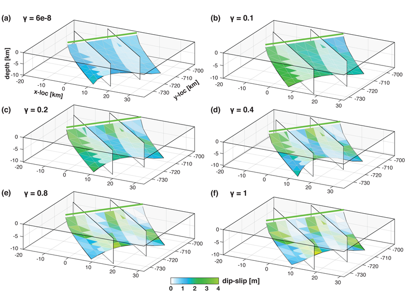
Series of six figures showing recovered fault geometry and slip models, from early to late stages in the inversion procedure.
Posted inEditors' Highlights

New Inversion Method Improves Earthquake Source Imaging

by Cécile Lasserre 30 August 202115 September 2026

A new method uses Bayesian inference to jointly invert for non-planar fault geometry and spatially variable slip (with associated uncertainties) in earthquake source modeling, based on geodetic data.

An extratropical cyclone over the U.S. Midwest
Posted inResearch Spotlights

Improving Weather Simulations Through Increased Generality

by Morgan Rehnberg 3 August 20218 July 2024

By adding support for spatially variable velocity fields and anisotropy, the CoSMoS simulation package can more accurately reproduce physical phenomena.

Photograph of The Great Unconformity visible in The Grand Canyon
Posted inEditors' Highlights

The Great Unconformities?

by Peter van der Beek 3 August 20219 December 2022

New thermochronology data and thermal history modeling from the Canadian Shield show that the Great Unconformity formed there later than elsewhere in North America and may represent another event.
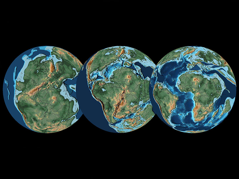
During the Mesozoic, the fragmentation of Pangaea contributed to long-term climate trends.
Posted inResearch Spotlights

Simulating 195 Million Years of Global Climate in the Mesozoic

by Jack Lee 30 July 20217 October 2021

An ensemble of climate simulations identifies factors that drove long-term trends of a prehistoric greenhouse climate.
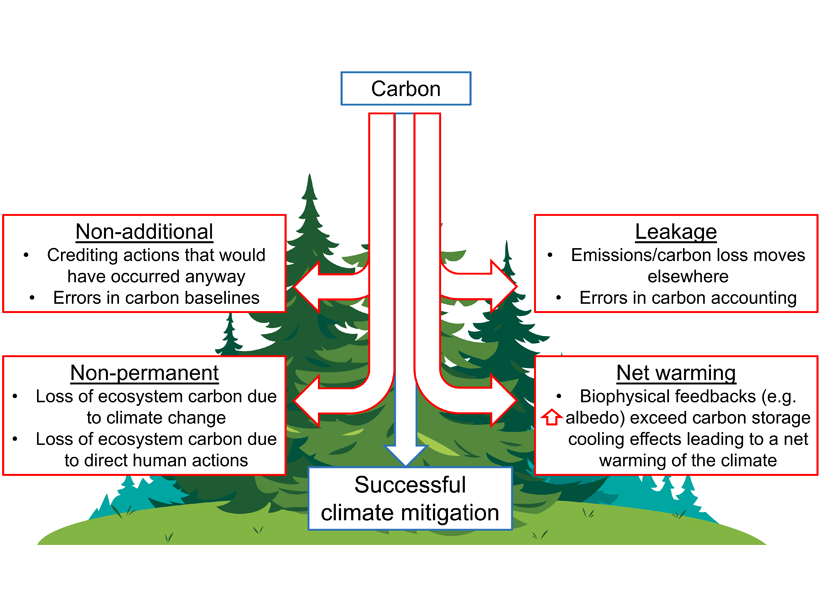
Figure showing key requirements for making forest-based natural climate solutions successful for climate mitigation, with examples of potential pitfalls are shown for each category.
Posted inEditors' Highlights

Permanence of Nature-Based Climate Solutions at Risk

Eric Davidson, president-elect of AGU by Eric Davidson 22 July 20211 June 2023

Conserving native ecosystems helps sequester carbon and mitigate climate change, but new statistical modeling questions the permanence of California’s carbon-rich forests with climate change.

The San Andreas Fault near Juniper Hills, Calif.
Posted inResearch Spotlights

A New Method Produces Improved Surface Strain Rate Maps

by Jack Lee 19 July 202115 September 2026

The transdimensional Bayesian approach handles GPS data limitations better than existing methods and may assist future seismic hazard assessment studies.

Graphic by Rene Gauthier-Butterfield
Posted inEditors' Vox

Call for Papers on Machine Learning and Earth System Modeling

by J. Yuval, M. Pritchard, P. Gentine, L. Zanna and Jiwen Fan 15 July 20219 February 2022

Contributions are invited to a new journal special collection on the use of new machine learning methodologies and applications of machine learning to Earth system modeling.
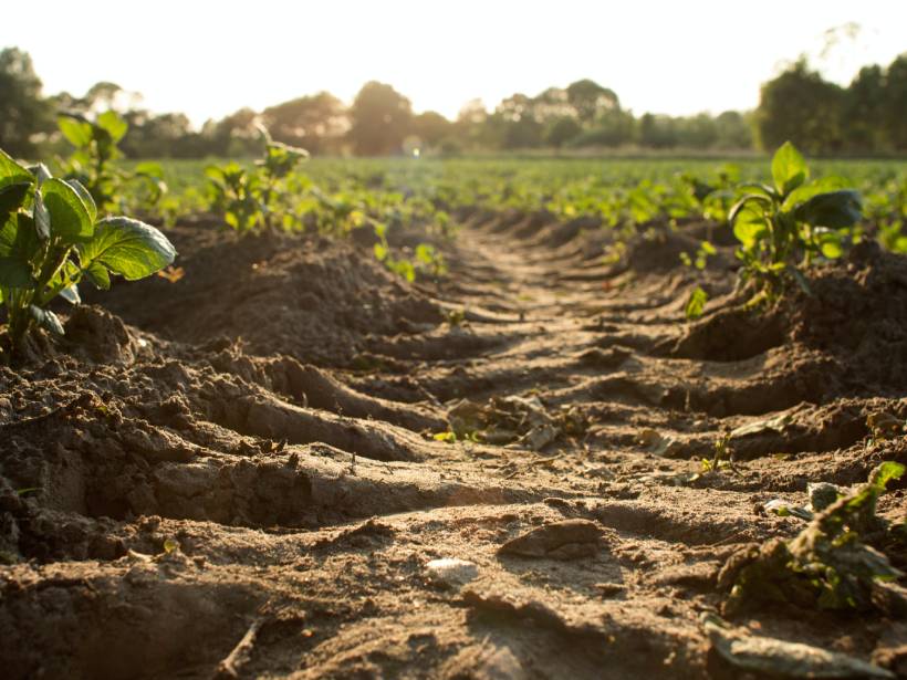
Vista desde el suelo de una marca de tractor en un suelo de un campo de cultivos
Posted inResearch Spotlights

Una mirada global al carbono orgánico superficial del suelo

by David Shultz 14 July 202112 January 2023

El carbono orgánico del suelo es un elemento importante para la salud de los ecosistemas y del clima. En la actualidad la teledetección permite a los científicos observar globalmente esta importante pieza del rompecabezas del carbono.
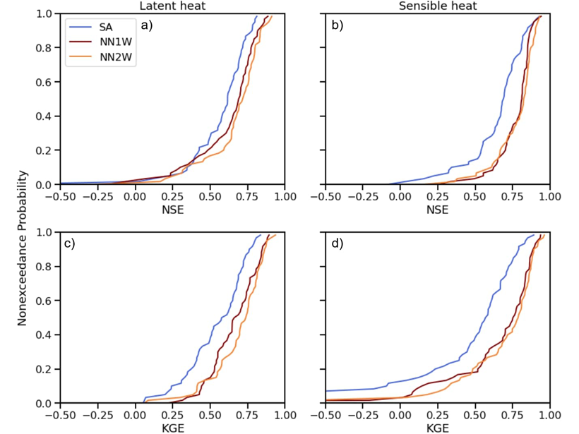
Four plots comparing the accuracy of predicted latent heat and sensible heat fluxes with observations from flux towers.
Posted inEditors' Highlights

Combining Deep Learning Methods with Process-based Models

by Marc F. P. Bierkens 2 July 20219 February 2023

Using turbulent heat fluxes as an example, a new study shows that exchange of information between process-based models and deep learning methods may lead to improved predictions.

Four photographs of Big Cypress National Preserve of South Florida.
Posted inEditors' Highlights

A New Model for Self-Organized Pattern Formation

by Ton Hoitink 1 July 202111 February 2022

Scale-dependent feedbacks in time, rather than in space, result in a new type of competition, explaining the regularly patterned landscape of Big Cypress National Preserve in South Florida.

Posts pagination

Newer posts 1 … 66 67 68 69 70 … 121 Older posts
Over a dark blue-green square appear the words Special Report: The State of the Science 1 Year On.

Features from AGU Publications

Research Spotlights

InSight into Seismology on the Red Planet

21 October 202621 October 2026
Editors' Highlights

The Geomagnetic Polarity Time Scale Revisited Once Again

22 October 202622 October 2026
Editors' Vox

Opening Access to Earth Observation Data for Disaster Mitigation

21 October 202620 October 2026
Eos logo at left; AGU logo at right

About Eos
ENGAGE
Awards
Contact

Advertise
Submit
Career Center
Sitemap

© 2026 American Geophysical Union. All rights reserved Powered by Newspack