No single place on Earth displays the consequences of climate change as much as Greenland. The island is largely covered with an ice sheet, which contains enough water to raise global ocean levels by several meters were it all to melt. Even losing a fraction of that ice will flood island nations and coastal cities around the planet.
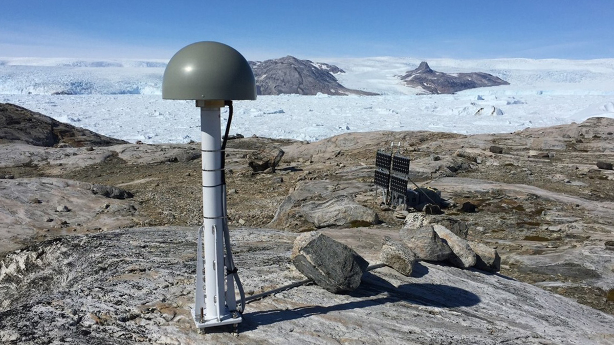
How quickly this happens depends on the path of the meltwater from ice sheet to sea and how long it takes, though spotting that complicated journey under the ice has been difficult. A recent study published in Nature tracked this water into and out of hidden pools beneath the surface by analyzing subtle changes in the vertical motion of the bedrock in Greenland, using Global Navigation Satellite System (GNSS) stations.
“You can imagine that the solid Earth behaves like a very stiff spring,” said geoscientist Pavel Ditmar of Delft University of Technology. “When the surface load is removed, then the solid Earth returns to its original position. The deformations are relatively minor, but if we remove all the signals of no interest, we come up with a signal amplitude of about 5 millimeters. But nevertheless, the accuracy of GNSS receivers is sufficient to detect these deformations.”
“What we consider as warm summers nowadays may became ordinary in the future.”
Using these data, Ditmar and his collaborators showed that meltwater collects within and beneath the Greenland ice sheet during warm summer months. The water can linger in these hidden reservoirs for 1–2 months before draining to the ocean, a previously unknown lag that has important implications for climate change models.
“Being able to directly measure these quantities is super informative for how we model subglacial hydrology and how these glaciers are going to respond to changing conditions in the future,” said Michalea King, a University of Washington ice sheet researcher who was not involved in the study. (King is a science adviser at Eos.)
“What we consider as warm summers nowadays may became ordinary in the future,” Ditmar warned, pointing out that models currently underestimate by 20% or more how much hidden meltwater there is. “If we are concerned about future sea level rise, it’s critical to make a proper adjustment of existing models.”
Secret Lakes and Hidden Flows
Climate change’s amplified effect in the Arctic makes Greenland one of the most immediately vulnerable places on Earth. However, direct measurement of melting and its contribution to sea level rise is difficult, and fieldwork is often impossible.
“This paper is really, really important because it provides direct observations of how much water is not immediately making its way out to the ocean.”
“It’s really challenging to observe how water moves through the subglacial hydrology system in Greenland,” King said, adding that many glaciers end in the ocean rather than on dry land. “They’re inaccessible and can be dangerous environments. We think we understand the basics of subglacial drainage, but we’re just sort of inferring what’s going on at the bed. This paper is really, really important because it provides direct observations of how much water is not immediately making its way out to the ocean.”
The new study uses 22 GNSS stations built on solid rock around the ice sheet’s periphery. The stations can monitor tiny vertical shifts in the rock in real time, spanning 200 kilometers around each station.
Ditmar and his collaborators used these data to reconstruct what happens inside and beneath the ice sheet through the spring and summer melt seasons.
Starting in February of each year, each GNSS station recorded a slow then accelerating downward displacement as meltwater from the entire surface of the ice sheet drained through channels in the ice and accumulated in hidden lakes between the ice and the bedrock. That subsidence reached its maximum in July and was followed by a slow rebound as the water drained to the ocean.
Differences in the amount of subsidence between stations showed regional differences likely due to ice sheet structures: In the southeast, where glaciers flow directly into the ocean, the rebound was much faster than elsewhere in the ice sheet where there is more exposed rock between the ice sheet and open sea.
Current ice sheet models do not include the possibility of meltwater storage over months-long periods, so by comparing the subsidence and rebound of rock to what these theories predict, the researchers isolated just how much water is present, how long it is stored, and how quickly it drains to the ocean. They also double-checked their conclusions using data from the GRACE-FO (Gravity Recovery and Climate Experiment Follow-On) satellites, which use gravity measurements to track movement of mass. Though these can’t provide the same resolution in space and time as GNSS, the satellites provided independent confirmation of the total compression and rebound.
The result showed that researchers are greatly underestimating hidden water flows on ice sheets and how they contribute to sea level rise. However, it also is a necessary correction to current climate models, with implications for improvements beyond Greenland. Though the GNSS method likely won’t work for the lower ice mass in alpine glaciers or where little bare rock is exposed, as in Antarctica, improvements to theory from this work could guide researchers in their understanding of how vulnerable ice melts—before it is all gone.
—Matthew R. Francis (@BowlerHatScience.org), Science Writer