
On 8 February, magma erupted near Grindavík, a city of about 3,600 along the southern coast of Iceland’s Reykjanes Peninsula, for the third time in as many months. Volcanologists recently analyzed the structure of the region’s underground magma system and found that pent-up tectonic stress drove ultrafast magma flow within a 15-kilometer-long (9-mile) dike.
Tracking how pressure builds in magmatic systems before an eruption is key to better understanding volcanic hazards, said Freysteinn Sigmundsson, a volcanologist at the University of Iceland in Reykjavík and lead researcher on the project.
Modeling complex magma networks such as this one adds to the volcanologist’s toolbox, he said, and could help scientists better understand dike behavior in Iceland, elsewhere around the world, and at other locations with diverging crustal plates.
Splitting the Crust Is Stressful
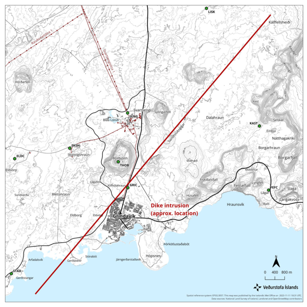
In October 2023, seismic activity northeast of Grindavík began weeks of anticipation that an eruption was imminent. By November, the seismic activity migrated southwest in a line extending from Sundhnúkur crater row to Grindavík and to under the ocean floor.
At the same time, the underground magma network near Svartsengi, north of Grindavík, deflated, suggesting that the quakes were caused by magma flowing through a rapidly growing dike beneath the region. The ground deformation and seismic activity prompted the evacuation of Grindavík’s residents, pets, and livestock in late November.
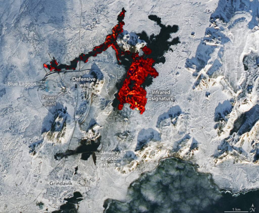
In early December, geodetic and radar measurements detected renewed inflation of the ground near Svartsengi. Scientists estimated that 9 million cubic meters (318 million cubic feet) of magma had accumulated about 5 kilometers (3 miles) underground. On 18 December, a 4-kilometer (2.5-mile) fissure along the dike erupted. The eruption was dramatic but brief, emplacing roughly 3.5 square kilometers (860 acres) of lava in less than 3 days, most within the first few hours.
The cycle of deflation, seismicity along the dike, and then inflation repeated itself in early January, and two more fissures erupted on 14 January. That eruption, briefer than the one in December, destroyed three houses in Grindavík.
Using seismic data from the Icelandic Meteorological Office and ground deformation data from satellites—including hourly geodetic observations from the Global Navigation Satellite System (GNSS) and interferometric synthetic aperture radar (InSAR)—researchers modeled the magma system that fed those eruptions and tracked its growth and eruptions.
The researchers found that the maximum magma flow rate occurred on 10 November, before the initial fissure erupted, reaching 7,400 cubic meters (260,000 cubic feet) per second.
That’s 2–3 orders of magnitude higher than those seen in the eruptions of nearby Fagradalsfjall in 2021, 2022, and 2023 but comparable to the rate seen at the start of the 9-month-long Laki eruption in 1783–1784.

The 10 November flow rate was also an order of magnitude higher than during the December, January, and February eruptions, Sigmundsson said. “The biggest event was the first one, when there was no eruption.”
In general, magma flow rates are driven by a combination of buoyancy (magma is less dense than surrounding crustal rocks and wants to rise up) and inflow pressure (magma flowing into a space-limited reservoir pushes existing magma outward). But achieving ultrahigh flow rates such as those observed near Grindavík, the researchers argue, requires a third driver: tectonic stress from the crust surrounding the forming dike.
Their model showed that magma and partially melted rock accumulated in multiple sills deeper in the crust. Along what would become the path of the dike, tectonic stresses pulling apart the crust had formed a preexisting weakness in the crust.
When a large enough opening released the magma from below, it rapidly flowed along the stressed path and created the 15-kilometer (9-mile) northeast–southwest oriented dike. The surface eruptions that followed occurred after pressure had built up within the dike, enough that it split the ground to release lava.
Tectonic stress played as much of a role as buoyancy and magma inflow pressure in forming the Grindavík dike, Sigmundsson said. This research was published in Science on 8 February.
Three for Three
“The location and dimensions of the dike make sense,” said Michael Manga, a geophysicist and physical volcanologist at the University of California, Berkeley, who was not involved with the research. “The idea that plate tectonic motion, i.e., spreading of the Atlantic, gradually accumulates stress and enables the dike to form also makes sense. It is nice to be able to test and confirm these ideas.”
On 8 February, shortly after the study was published, a third eruption began from a 3-kilometer (2-mile) fissure near the site of the December eruption. The lava flow from the February eruption damaged a pipeline from the Svartsengi power plant and cut off hot water to nearly 20,000 people.
Though that recent eruption was not included in the analysis, Sigmundsson said it followed roughly the same pattern as the previous two: weeks of seismic activity followed by an intense but brief fissure eruption. The February eruption was consistent with the magma network model developed from the prior two eruptions, he said.
The processes that drove the high flow rate into the Grindavík dike could also be at play on the flank of Kīlauea in Hawaii, in the Afar rift off Africa’s eastern coast, and in Newberry caldera in the Cascades, Sigmundsson said. “Everywhere on the planet where we have extensional stresses, that can be a really effective driving pressure for magma intrusions,” he said.
—Kimberly M. S. Cartier (@AstroKimCartier), Staff Writer