
An international collaboration is using historical records and modeling to assess tsunami potential in this high-risk region.
Science Updates

Posted inScience Updates
A Cross-Sectoral Approach to Tackle Ocean Plastic Pollution
Plastic in the Oceans: Challenges and Solutions; Cambridge, United Kingdom, 7 March 2018

Posted inScience Updates
Agencies Collaborate to Better Monitor and Model the Environment
Interagency Collaborative for Environmental Modeling and Monitoring: Monitoring and Model Data Fusion; Rockville, Maryland, 24–25 April 2018

Posted inScience Updates
A Modeling Toolbox for Permafrost Landscapes
A new resource makes it easier for researchers to explore predictions of how melting permafrost might affect carbon release, wetlands, and river deltas as they evolve and other interacting effects.
Posted inScience Updates
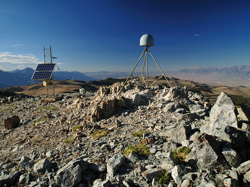
Harnessing the GPS Data Explosion for Interdisciplinary Science
More GPS stations, faster data delivery, and better data processing provide an abundance of information for all kinds of Earth scientists.

Posted inScience Updates
New Achievements in Coastal Altimetry
11th Coastal Altimetry Workshop; Frascati, Italy, 12–15 June 2018
Posted inScience Updates
Can We Build Useful Models of Future Risk from Natural Hazards?
Geoprocesses, Geohazards—CSDMS 2018: A CSDMS hosted Workshop; Boulder, Colorado, 22–24 May 2018

Posted inScience Updates
Lightning: A New Essential Climate Variable
Lightning is a symptom and a cause of climate change. A recently established task team is working to make lightning data available and useful for climate science and service applications.
Posted inScience Updates
Better Data for Modeling the Sun’s Influence on Climate
Several international initiatives are working to stitch together data describing solar forcing of Earth’s climate. Their objective is to improve understanding of climate response to solar variability.
Posted inScience Updates
Scientists Meet to Review Preparations for Satellite Launch
Center for Satellite Applications and Research JPSS 2017 Annual Science Team Meeting; College Park, Maryland, 14–18 August 2017