• About
  • Special Reports
  • Topics
    • Climate
    • Earth Science
    • Oceans
    • Space & Planets
    • Health & Ecosystems
    • Culture & Policy
    • Education & Careers
    • Opinions
  • Projects
    • Postcards From the Field
    • ENGAGE
    • Editors’ Highlights
    • Editors’ Vox
    • Eos en Español
    • Eos 简体中文版
    • Print Archive: 2015–2025
  • Policy Tracker
  • Blogs
    • Research & Developments
    • The Landslide Blog
  • Newsletter
  • Submit to Eos
  • AGU.org
  • Career Center
  • Join AGU
  • Give to AGU
  • About
  • Special Reports
  • Topics
    • Climate
    • Earth Science
    • Oceans
    • Space & Planets
    • Health & Ecosystems
    • Culture & Policy
    • Education & Careers
    • Opinions
  • Projects
    • Postcards From the Field
    • ENGAGE
    • Editors’ Highlights
    • Editors’ Vox
    • Eos en Español
    • Eos 简体中文版
    • Print Archive: 2015–2025
  • Policy Tracker
  • Blogs
    • Research & Developments
    • The Landslide Blog
  • Newsletter
  • Submit to Eos
Skip to content
  • AGU.org
  • Career Center
  • Join AGU
  • Give to AGU
Eos

Eos

Science News by AGU

Support Eos
Sign Up for Newsletter
  • About
  • Special Reports
  • Topics
    • Climate
    • Earth Science
    • Oceans
    • Space & Planets
    • Health & Ecosystems
    • Culture & Policy
    • Education & Careers
    • Opinions
  • Projects
    • Postcards From the Field
    • ENGAGE
    • Editors’ Highlights
    • Editors’ Vox
    • Eos en Español
    • Eos 简体中文版
    • Print Archive: 2015–2025
  • Policy Tracker
  • Blogs
    • Research & Developments
    • The Landslide Blog
  • Newsletter
  • Submit to Eos

Editors’ Highlights

Large rock balanced on cliffside
Posted inEditors' Highlights

Earthquake Hazard Hanging in the Balance

by T. Parsons 1 October 202011 February 2022

Earthquake hazard calculations for California’s coast are refined with a view of precariously balanced rocks that would have fallen if the largest predicted shaking happened in the past 20,000 years.

Right: Image of a solar flare observed on 19 October 2014. Left: Diagram showing configuration of the planets at the time of the flare
Posted inEditors' Highlights

The Importance of Solar Lyman-alpha Emissions for Space Weather

by Michael A. Hapgood 29 September 202013 October 2022

Lyman-alpha emissions convey a major part of the solar-flare photon energy reaching Earth and play a significant role in flare-driven enhancements of ionospheric conductivity.

Series of global maps showing virtual geomagnetic pole paths as calculated from the Black Sea paleomagnetic directional record
Posted inEditors' Highlights

The Restless Geomagnetic Field Over the Past 70,000 Years

by Bjarne S. G. Almqvist 25 September 202030 September 2022

Detailed paleomagnetic records from Black Sea sediments reveal intricate changes in the field during geomagnetic excursions.

Charts showing the system performance of the flood protection strategy and conventional systems
Posted inEditors' Highlights

Rainwater Harvesting Can Reduce Flooding as Well as Saving Water

by Jim Hall 23 September 202024 February 2023

Weather forecasting can greatly improve benefits of rainwater harvesting.

Photograph showing debris in an urban water drainage channel
Posted inEditors' Highlights

Environmental Impact Bonds Incentivize Watershed Restoration

by Jim Hall 21 September 20206 January 2022

Environmental Impact Bonds for financing new water and environmental infrastructure can be properly priced with the help of watershed modelling.

Posted inEditors' Highlights

Ensemble Modeling of Coronal Mass Ejection Arrival at 1 AU

by Mary Hudson 18 September 202031 May 2022

Heliospheric imaging data can be used in ensemble modeling of CME arrival time at Earth to improve space weather forecasts, treating the solar wind as a 1-D incompressible hydrodynamic flow.

Map of observations of hurricanes and their paths
Posted inEditors' Highlights

What the Upper Ocean Looks Like During a Hurricane and Why It Matters

by Eileen Hofmann 17 September 202010 March 2022

High-resolution measurements reveal the structure of the upper ocean under a hurricane and its feedback on storm intensity.

Six sequential radar reflectivity scans of Hurricane Michael as it developed
Posted inEditors' Highlights

The Evolution of Observed Hurricane Eyewall Shapes

by Suzana Camargo 16 September 202025 February 2022

The observational evidence of the wind field of Hurricane Michael using radar imagery showed an eyewall structure evolution with elliptical, triangular, and square shapes for the first time.

Four proposed models of the structure within the Himalaya with different associated thermal fields
Posted inEditors' Highlights

Deconvolving What Lies Beneath the Himalaya

by Taylor Schildgen 14 September 202023 September 2022

A new study that combines constraints from the 2015 Gorkha earthquake, forward models of deforming crust, and thermochronology data gives new insights into the structure of the Himalaya.

Histogram of temperature estimates for carbonate rocks
Posted inEditors' Highlights

Measuring Paleoclimate During a Deep-Time Deep Freeze

by Peter Zeitler 11 September 202023 January 2023

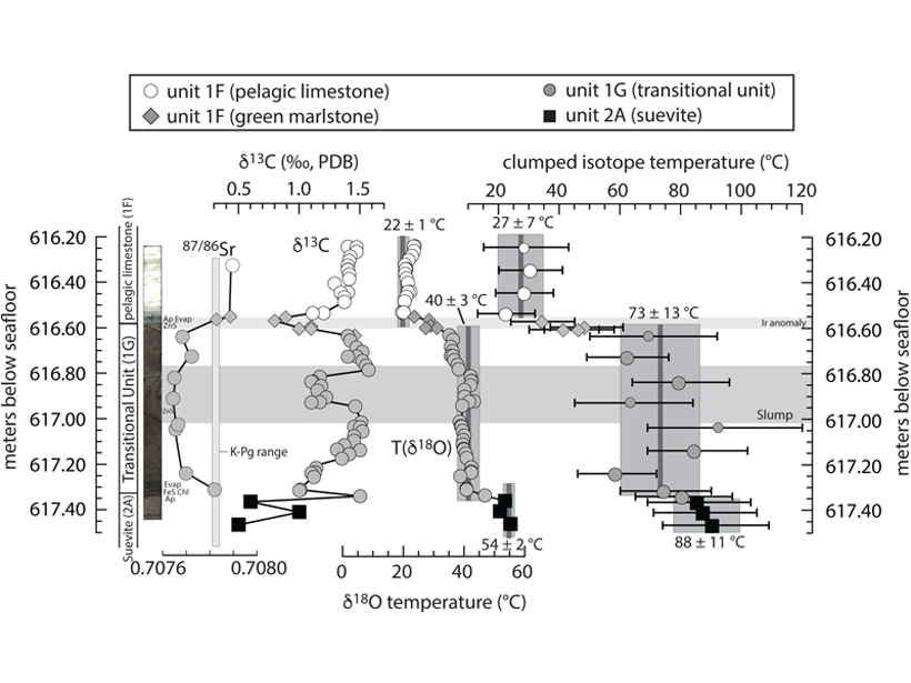
New application of clumped-isotope thermometry to 700-Myr rocks documents large climate swings related to Snowball Earth glaciation and offers better understanding of an earlier Earth system.

Posts pagination

Newer posts 1 … 85 86 87 88 89 … 118 Older posts
Over a dark blue-green square appear the words Special Report: The State of the Science 1 Year On.

Features from AGU Publications

Research Spotlights

It Takes Three to Model Methane Right

20 August 202620 August 2026
Editors' Highlights

Tectonics and Deglaciation Govern Eastern-Southern Alps at Slow Rates

20 August 202618 August 2026
Editors' Vox

Decoding the Origins of Lightning’s Violent Currents

19 August 202619 August 2026
Eos logo at left; AGU logo at right

About Eos
ENGAGE
Awards
Contact

Advertise
Submit
Career Center
Sitemap

© 2026 American Geophysical Union. All rights reserved Powered by Newspack