
Air quality is one of the biggest hazards associated with wildfires—for good reason.
As the air quality index approaches 300 (anything above which is considered hazardous), communities are forced to react. In 2018 in Portland, Ore., wildfires contributed to an air quality index of 157. Schoolchildren were forced to stay inside, outdoor activities were canceled, and local and state governments issued warnings to avoid breathing unfiltered air. In 2015, smoke from wildfires in Palangkaraya, Kalimantan (Indonesian Borneo), pushed the air quality index to 2,000. The air during that fire season caused 500,000 people to develop significant respiratory infections and was estimated to have caused the premature deaths of 100,000 people.
Wildfire emissions that influence air quality are dependent on the biomass feeding the fire. Biomass describes organic (mostly plant) material, including surface debris, the tree canopy, and belowground roots and peat.
All fires emit carbon dioxide, carbon monoxide, and particulate matter, including white (organic) carbon and black carbon. But largely because of biomass and other inputs, the exact makeup of smoke varies for every fire on Earth, from forest fires in the Pacific Northwest to peat fires in Southeast Asia to bushfires in Australia.
It’s All About Combustion
“All fires emit carbon dioxide because [fire is] a combustion process,” says Christine Wiedinmyer, an atmospheric chemistry modeler and associate director for science at the Cooperative Institute for Research in Environmental Sciences in Boulder, Colo. Combustion is a chemical reaction that produces heat, and wildfires can produce incomplete or complete combustion.
Fires can be smoldering, flaming, or both. They can burn at the very crown of a forest, jumping from treetop to treetop, or at the ground surface, igniting grass, shrubs, young trees, and ground debris of the understory. Some fires even burn belowground. Belowground fires can burn up to the surface, even reaching the tree canopy, or they can burn from the canopy down.
Each fire’s exact emissions cocktail is partially “determined by the way the fire is burning,” Wiedinmyer said. “If you have a flaming fire, you may have more complete combustion, more black smoke. If something is smoldering, you have less complete combustion, and that’s when you get the white organic carbon, white smoke, like [from] your charcoal grill.”
Big forest fires in Australia and California, which have superhigh burn intensities, often produce complete combustion, said Mark Cochrane, a professor at the University of Maryland Center for Environmental Science. Carbon dioxide and black carbon are primary emissions of these fires.
The temperature and intensity of the combustion processes also control chemical releases, explained Robert Yokelson, an atmospheric chemist at the University of Montana. Fire behavior, in general, affects the relative amount of flaming, glowing, distillation, and pyrolysis, and to some extent, pyrolysis temperatures have an impact on what volatile organic compounds are emitted. For example, he said, higher pyrolysis temperatures are needed to make benzene, a carcinogen sometimes released during wildfires that can affect a region’s air, soil, and water infrastructure.
As does, of course, the biomass, Wiedinmyer said.
Burning Biomass
Every type of biomass produces its own unique chemistry, and atmospheric chemists generally recognize six categories of biomass when evaluating a wildfire’s chemical signature: savanna (think Africa), tropical forest (think Amazon or Indonesia), temperate forest (think Sierra Nevada, Pacific Northwest, or northern Europe), boreal forest (think Siberia or Alaska), chaparral (think Southern California or Greece), and peatlands, which can be either tropical (Indonesia) or boreal (Siberia or far northern Canada). Of course, “the biomass of grasslands, shrublands, and forests is extremely variable, and mapped values are associated with a high degree of uncertainty,” according to new research from scientists working to incorporate such variability into new biomass mapping models.
For an example of how biomass influences wildfire emissions, consider the chemical signatures of emissions from a temperate forest, a tropical forest, and a savanna. Temperate forests with pines emit compounds such as pinene when they burn. These compounds can form into secondary organic aerosols, adding to the fire’s directly emitted black and organic carbon. They can also, to a much smaller extent, affect ozone chemistry. In the Amazon basin, biomass is dominated by the fresh, green canopy of the tropical forest. This type of biomass releases nitrogen-rich compounds when it burns, said Yokelson. Nitrogen is emitted in major quantities as ammonia, nitrous oxide, or nitrogen dioxide. All of these compounds are precursors for the secondary formation of particulate matter and ozone. In comparison, the brown grasses of African savannas or California hillsides emit far less nitrogen but are more likely to emit such compounds as black carbon.
Worldwide, savannas and tropical forests contribute the most burning-related emissions to the atmosphere. Savannas span 20% of Earth’s terrestrial surface but produce more than half of global mean fire emissions. In fact, from 1997 to 2016, savannas represented 62% of fire emissions, according to a paper published in 2018 in Nature Communications.
The burning of savanna grasslands produces significant amounts of black carbon—about 2 kilograms per hectare, Yokelson said. But “it’s not as simple as that,” he explained, because fires in forests consume more fuel than fires in savannas, so they can produce more emissions per unit area.
Peatlands, meanwhile, represent just 3% of terrestrial land cover but hold a third of the world’s carbon, so when they burn, they can produce significant emissions, Yokelson and colleagues noted in a paper published in 2011 in Atmospheric Chemistry and Physics. And peatland emissions are vastly different from other types of biomass emissions.
Sumatra and Kalimantan, Indonesia, account for about half of the tropical peatlands on Earth. In these areas, Cochrane said, peat has a mean depth of 5.5 meters and can sometimes reach 10 meters deep. People regularly drain these peatlands and (illegally) set fires to clear the landscape, largely for oil palm plantations. The problem is, after those fires start, they are very difficult to put out. The aboveground tropical forests may burn rather quickly, but the peat underground can burn for months, often being extinguished only when the rainy season sets in, said Laura Kiely, a graduate student at the University of Leeds in the United Kingdom who led a study recently published in Atmospheric Chemistry and Physics on particulate emissions from Indonesian peat fires.
Peatlands have a vast fuel source, said Robert Field, a scientist at Columbia University in New York, and after they start burning, “they don’t stop pumping out smoke.”
That smoke is thick and white, filled with organic carbon, methane, carbon monoxide, and significant amounts of particulate matter 2.5 micrometers or smaller in size (PM2.5), Cochrane said. It hangs in the air above Indonesia and then travels regionally, reducing air quality as far away as in Malaysia and Singapore.
Sensing the Smoke
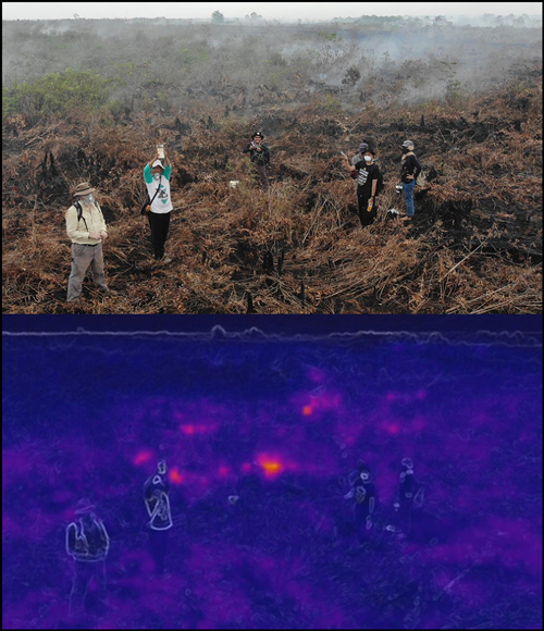
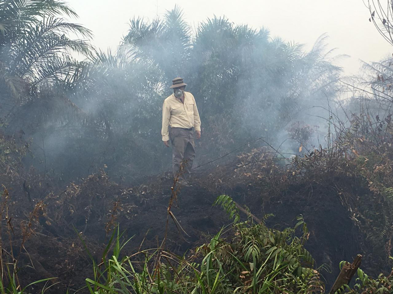
Cochrane and his team traveled to Indonesia in 2015 and again in 2019 to collect emissions data from peatlands directly. The air was so thick it felt like you could cut it with a knife, Cochrane said. The air quality index reached over 2,000 in September 2019.
To get the data they needed, researchers “took a lab to the field.”
To get the data they needed, the researchers “took a lab to the field,” Cochrane said. They “ran around on coals”—one grad student’s shoes burned through—collecting air samples directly above peat fires.
For safety, they wore masks while in the thick of the smoke, but because the haze of PM2.5 blanketed the whole region, the masks “[didn’t] help much,” Cochrane said. “Even if we wear masks while standing over smoldering fires, we don’t wear them when farther away, or eating, or at night….When the smoke becomes ubiquitous, you basically cannot escape it. Near the fire looks bad, but much of the smoke is [of] larger particulates that aren’t as health-impacting and will settle out relatively soon. The haze that hangs over the region for weeks and months is made up of the smaller PM2.5 particulates that settle deep into your lungs.” Cochrane said it usually takes a few weeks after returning home for his lungs to clear out.
It is dangerous but important work, Kiely noted, because peatland emissions are not well accounted for in models.
When Kiely started trying to determine how Indonesian fires affect climate—by looking at models of fires and emissions—she found very little data. The model Wiedinmyer created, Fire Inventory from the National Center for Atmospheric Research (FINN), did not include peat. The other major emissions model, the Global Fire Emissions Database (GFED), does include peat, but the emissions factors are underestimated, Kiely said.
So Kiely started working with Wiedinmyer on creating a database of peatland emissions based on research by Yokelson, Cochrane, and others.
Some of these measurements are taken on foot, but more are taken from the air. Yokelson likes to fly through smoke at about 30–300 meters above the flames and then follow smoke plumes as far as he can to measure smoke evolution. During the 2013 Rim Fire in California, for instance, he and a large cohort of colleagues working with NASA followed the plume northward through Winnipeg, Manit., Canada.
The goal, Yokelson said, is to get as close as you can to the start of the fire to measure the emissions there and then to fly across the plume at various intervals downwind, say, every 15 kilometers or so. That way, he said, “you can see what the emissions are doing in the atmosphere—how they’re reacting. For example, is formaldehyde increasing or decreasing? What’s ozone doing? How much and how fast ozone forms is critical for both air quality and climate. What’s particulate matter doing—how far away is it traveling?”
Modeling the Movement
Chemists have made incredible advances, in the past 5 years especially, and “we [modelers] are behind—we’re just trying to catch up.”
Chemists have made incredible advances, Wiedinmyer said, and “we [modelers] are behind—we’re just trying to catch up.”
“They [atmospheric chemists] have tools that can identify hundreds of compounds in biomass burning plumes. They say, ‘Here’s our list of 300 compounds that we can quantify, and we can give you emissions factors,’” she said. “We take that and try to apply it based on what we know about where and when fires are burning and what types of vegetation are burning and create a model.”
The stronger emissions data have enabled models to better match observations, Wiedinmyer said. Models show that it is not just types of biomass that affect emissions, but it is also the condition of the fuels, such as how wet or dry they are, and the amount of fuel that burns. “It’s all connected, all very complicated, and quite a challenge.”
In Canada, researchers like Jack Chen, a modeling scientist at Environment and Climate Change Canada (ECCC), are incorporating fire emissions into the air quality forecast system. They developed FireWork, a forest fire smoke model that relies on satellites to estimate wildfire emissions and uses forecast meteorology to simulate emissions dispersion, including everything from PM2.5 to ozone to nitrous oxides—any pollutants used in the air quality health index, Chen said. ECCC started using this system in 2016, and researchers have improved it every year since then by using better data from forest scientists, he said. The fire emissions models incorporate biomass density; fuel level burned; combustion efficiency; combustion type; combustion intensity (smoldering versus flaming); and even plume rise, using fire energy thermodynamics to determine plume injection heights, which help simulate how far emissions will travel, Chen said.
With FireWork version 2.0, which was used during the 2019 fire season, “we found that with better representation of fire emissions, we were able to better simulate the formation of PM2.5 and ozone from these fires,” Chen said. Depending on plume height, heat, intensity, changes in convection, and other factors, models have shown that PM2.5 can travel hundreds to thousands of kilometers away, and ozone can travel across continents, he said.
But there is still a lot of uncertainty surrounding emissions research, Chen noted, especially about feedback mechanisms and how fire emissions affect things like rainfall, ecosystems, and global warming.
A Clearer or Hazier Picture?
“How will fire change under a warming climate?” Field wondered. “What is the future of fire…and how do we predict high fire danger” early enough to make a difference?
In the past, for example, scientists knew that in an El Niño year, Indonesia would be drier than normal and fires likely would be severe. In 2019, however, an emerging climate pattern brought increased dryness to Indonesia and drought to Australia. This pattern contributed to severe fire danger in both countries. Scientists do not yet know how much of the climate pattern is related to global warming and how much it will change, Field said. “We’re hoping to untangle [that].”
Climate links to changing fire regimes are also important in California and the western United States, Field said. There, some research has suggested that vegetation types are changing in the wake of fires: The old vegetation, which may have adapted to less intense cyclical fires, is not coming back the same way. For instance, Yokelson said, forests may be converted to brush. Changes in vegetation can alter how emissions are offset by regrowth and can also alter fire return intervals, compromising an ecosystem’s ability to recover, he said.
Another question scientists are asking, Field said, is how individual or regional fires affect worldwide climate. In simple terms, black carbon (the type of emission common in grass fires) partially absorbs sunlight, causing warming; organic carbon (the type of emission common in peat fires) scatters sunlight, causing cooling. Carbon dioxide and other greenhouse gases increase temperatures; particulate matter can decrease temperatures.
It is easy to say that burning savannas release a lot of carbon dioxide and black carbon, so they warm the atmosphere, Yokelson said. But grass grows back quickly, so carbon dioxide is reabsorbed, halting the warming. And although burning peatland produces organic carbon and results seemingly in atmospheric cooling, there is no regrowth to offset the carbon dioxide produced—so there is actually net warming, he said. In the Amazon and Indonesia, deforestation causes significant emissions with little offset from biomass regrowth.
That said, when smoke fills the skies, temperatures drop locally, Yokelson said. In Montana, for example, he has seen a “forecast say, ‘Next week it’s going to be 100[°F],’ and then smoke from a fire fills the air, and temperatures only reach 80[°F].” Those effects are certainly felt most intensely close to a fire. Then, as the smoke spreads out downwind, a 20°F temperature drop becomes a 10°F drop, which becomes a 1°F drop even farther away, but covering a larger area.
But those local cooling effects are not the same as the greater climatic effects, he said. “Climate doesn’t care” whether it is smoky and cooler in Missoula or whether people cannot breathe in Portland or Kalimantan. Climate “cares” about the larger emissions volumes and reactions.
Radiative Results and Feedbacks
Some climate reactions involve changes in clouds and rainfall, Yokelson said. For example, recent research suggests that smoke particles create clouds with smaller droplets, which makes them less likely to rain. Smoke can also alter the thermal profile in the troposphere, affecting rainfall. But that is a “superactive area of research” with a lot left to learn, Field said.
Better integration of fire science and weather science would add clarity and help produce better forecasts of air quality, fires, and smoke.
Another area of active research, Yokelson said, is examining how fires change albedo: Green forests absorb less heat than black, burned vegetation. Regreening takes time as well. How much that affects local or global climate is unknown.
Fire’s effects on snowpack and runoff are further issues scientists are studying, Yokelson said. When snow falls on forests with complete canopies, much of it is caught in the canopies and evaporates. When snow falls on burned areas, it falls straight to the ground, building up snowpack and causing more runoff. All of these “secondary” effects are significant, he said, but how significant, scientists cannot say.
Better integration of fire science and weather science would add clarity, Chen said, and help produce better forecasts of air quality, fires, and smoke.
The whole system is complicated, Wiedinmyer said, and there is “a lot we just don’t have a great grasp on yet.”
—Megan Sever ([email protected]; @MeganSever4), Science Writer
Citation:
Sever, M. (2020), What is left in the air after a wildfire depends on exactly what burned, Eos, 101, https://doi.org/10.1029/2020EO138965. Published on 23 January 2020.
Text © 2020. The authors. CC BY-NC-ND 3.0
Except where otherwise noted, images are subject to copyright. Any reuse without express permission from the copyright owner is prohibited.