How do the oceans, atmosphere, and ice sheets interact with each other and with the solid Earth in our planet’s polar regions? What is Earth’s structure in these regions, and how did it evolve? Researchers must incorporate many scientific disciplines into their efforts to answer these questions, which are taking on greater societal relevance as increasing evidence points to strong linkages between shifting conditions in polar geosystems and global climate change.
Several challenges impede scientific advances stemming from seismological observations in ice-covered regions.
Researchers are turning to seismic methods to increase their understanding of the role that the solid Earth plays in ice sheet stability [Whitehouse et al., 2019] and to study ice sheet dynamics [Aster and Winberry, 2017] near Earth’s poles. However, several challenges impede scientific advances stemming from seismological observations in ice-covered regions. Gathering enough instruments and deploying them over the spatial and temporal scales needed to make detailed observations of ice sheet dynamics and solid Earth structures and processes is one example. Designing instruments that can function properly in polar environments is another.
The Geophysical Earth Observatory for Ice-Covered Environments (GEOICE) was developed to address these spatiotemporal observing challenges. The project was initiated in 2013 as a collaboration between Central Washington University, the Incorporated Research Institutions for Seismology (IRIS), and the IRIS Portable Array Seismic Studies of the Continental Lithosphere (PASSCAL) Instrument Center at the New Mexico Institute of Mining and Technology, with funding from the National Science Foundation (NSF) Major Research Instrumentation program.
Together, this group of institutions gathered a team of scientists, engineers, and managers to test and assemble a collection, or pool, of seismic instruments built to withstand icy or wet environments, reduce installation time and logistics, and optimize investigation of the structure and behavior of the solid Earth and ice in ice-covered areas. Off-the-shelf commercial models served as starting points for the instrument development, but our team of engineers and technicians at PASSCAL also conducted extensive testing on early versions of several Nanometrics Trillium broadband sensors and collaborated with the manufacturer to make changes and improvements.
Assembling the Instrument Pool
Today, the GEOICE resource consists of 265 seismic sensors, each with its own digitizer, plus associated support equipment, all designed to operate in temperatures as low as −40°C (Table 1). The GEOICE instrument pool includes 10 Nanometrics Trillium 120 broadband sensors, 55 Nanometrics Trillium Compact sensors, and 200 Magseis Fairfield Zland nodal sensors. This resource increases the size of the existing PASSCAL pool of polar-rated seismic instrumentation by nearly 50%. These instruments provide a range of detection capabilities, sensing vibrations with frequencies from 500 hertz to less than 0.01 hertz.
Table 1. Summary of Sensors in the GEOICE Equipment Pool
| Quantity | Instrument | Frequency Band | Weight |
| 10 | Nanometrics Trillium 120 posthole full broadband | <50 hertz | 16 kilograms |
| 55 | Nanometrics Trillium Compact posthole | ~0.01 to 100 hertz | 1.2 kilograms |
| 200 | Magseis Fairfield 3C Zland nodes | >5 hertz | 1.8 kilograms |
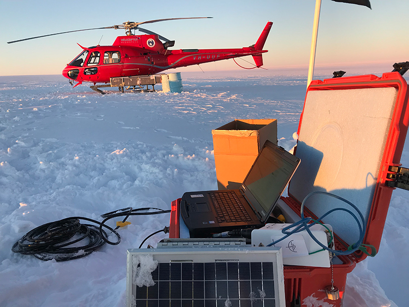
GEOICE sensors and digitizers are designed for rapid deployment—they can be buried directly in soil, ice, or snow, and they will continue to operate even when completely submerged in water. Their power supplies can vary to include solar panels and just a few batteries for short-term, summer experiments or solar panels with larger battery packs and enclosures capable of protecting batteries and digitizers in extreme conditions for long-term, multiyear polar experiments.

The 200 nodal seismic sensors—manufactured by Magseis Fairfield—are notable for their all-in-one design. This design incorporates the sensor, digitizer, battery, and onboard GPS system into a single, compact unit that can record continuously for approximately 1 month. Their modest form factor (size, weight, and overall design) enables extremely rapid deployments of sensors with a corresponding reduction in logistics costs.
The GEOICE instrumentation systems are designed to allow a wide variety of use case models with a distribution of sensing characteristics that enable array designs targeting specific wavefields while optimizing logistics. Individual principal investigators (PIs) can select the best mix of instruments—up to and including the entire pool—to suit the needs of their particular deployments. For example, sensors capable of recording the lowest frequencies (e.g., the Trillium 120s) could be spaced out more widely, whereas the sensors with the highest frequency sensitivity (e.g., the nodal sensors) might be used in closely spaced formations for maximum spatiotemporal resolution.
The size, width, and power consumption of the three classes of instruments in the pool also match their intended deployments, with the full-broadband instruments being the largest and heaviest and the nodes being the smallest, lightest, and easiest to deploy. In one upcoming experiment, researchers will use GEOICE nodes and Trillium Compact stand-alone sensors in an unprecedented study to monitor glacially generated seismicity and study mechanisms of ice mass loss from Thwaites Glacier in Antarctica.
Testing the Instruments

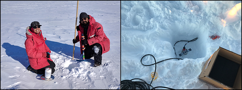
Initial testing of prototype instrumentation began in earnest in 2014 and continued through 2018. IRIS PASSCAL staff tested instrumentation to ensure its functionality, signal quality, communications capability, cold ratings, and power consumption. The photo to the right shows an example of pier testing, which involves vibrationally coupling the instrument to the ground below and decoupling it from vibrations caused by the surrounding building to test the lower limits of the vibrations that the instrument can record. In addition to bench and pier testing at PASSCAL, GEOICE instruments were also field tested in locations covering a wide range of temperatures and accumulation environments to confirm that the systems are capable of deployments throughout Earth’s polar regions.
The GEOICE team tested the instruments at Taku Glacier in Alaska, in a temperate glacier field where liquid water and ice coexist at temperatures near the freezing point. They installed stations in soft-dirt postholes on a glacial moraine as well as in ice postholes on the glacier itself. This testing provided the staff with key insights to installation limitations. For example, early instrument prototypes proved too large and unwieldy during the Taku deployment, which pushed the team toward smaller sensor designs. As a bonus, researchers used the data collected to study how the subglacial water system changed over time [Vore et al., 2019].

Staff also tested the full suite of GEOICE instrumentation in remote, extremely cold environments in Antarctica, including the Castle Rock test site near McMurdo Station (–20°C ± 30°C) and the South Pole Remote Earth Science and Seismological Observatory site near the South Pole (–50°C ± 40°C). In these extreme environments, the GEOICE team was able to evaluate key cold-weather performance characteristics of the instrumentation (e.g., power consumption, sensor operation, etc.) to ensure that they would meet project requirements.
Ready to Deploy
We expect that these instruments will be key in making observations of the interaction of the solid Earth with the cryosphere and atmosphere.
The GEOICE instrument pool provides scientists with a powerful new tool for making seismic observations in polar environments. The instruments can be used in diverse configurations to study a variety of phenomena in ice-covered regions, recording signals from the solid Earth, glacier movement, liquid water flow, and other relevant signals over a wide range of frequencies. We expect that these instruments will be key in making observations of the interaction of the solid Earth with the cryosphere and atmosphere to understand better how drivers such as climate change affect these systems.
The GEOICE instruments are made available to the research community via the NSF-funded Seismological Facilities for the Advancement of Geoscience (SAGE) program. SAGE supports the IRIS PASSCAL Instrument Center, which houses and maintains the instruments under the terms of a memorandum of understanding with Central Washington University.
Interested PIs are encouraged to apply to use the equipment via the standard instrument request process on the PASSCAL website. The instrumentation is free to use for any NSF-funded PI. All data collected will be archived at the IRIS Data Management Center, where it will be free and open for community use, following the accepted IRIS data policies.
Acknowledgments
GEOICE was funded by NSF under awards PLR-1337861 to IRIS and PLR-1337548 to Central Washington University. We thank NSF for recognizing the need for next-generation array capabilities in the polar seismic equipment pool and for funding the GEOICE project. Thanks also go to Nanometrics for responding to our vendor solicitation and for working closely with the IRIS PASSCAL staff to understand and improve the hardware and software components of the instrumentation. We also recognize the NSF SAGE award (EAR-1851048) and the NSF Office of Polar Programs (via EAR-1851037) for their support of this project through the standard pool of equipment as part of PASSCAL. The success of our field testing at Taku Glacier in Alaska would not have been possible without assistance provided by Jason Amundsen. We acknowledge the efforts of Doug Wiens, Rick Aster, and Andy Nyblade, who participated in writing the original GEOICE proposal.
References
Aster, R. C., and J. P. Winberry (2017), Glacial seismology, Rep. Prog. Phys., 80(12), 126801, https://doi.org/10.1088/1361-6633/aa8473.
Vore, M. E., et al. (2019), Seismic tremor reveals spatial organization and temporal changes of subglacial water system, J. Geophys. Res. Earth Surf., 124(2), 427–446, https://doi.org/10.1029/2018JF004819.
Whitehouse, P. L., et al. (2019), Solid Earth change and the evolution of the Antarctic Ice Sheet, Nat. Commun., 10, 503, https://doi.org/10.1038/s41467-018-08068-y.
Author Information
Justin Sweet ([email protected]), Incorporated Research Institutions for Seismology (IRIS), Socorro, N.M.; J. Paul Winberry and Audrey Huerta, Central Washington University, Ellensburg; Kent Anderson, IRIS, Socorro, N.M.; Bruce Beaudoin, PASSCAL Instrument Center, Socorro, N.M.; Susan Bilek, New Mexico Institute of Mining and Technology, Socorro; Paul Carpenter, Kevin Nikolaus, Aurora Roth, Kirsten Arnell, and Narendra Lingutla, PASSCAL Instrument Center, Socorro, N.M.; and Bob Woodward, IRIS, Washington, D.C.
Citation:
Sweet, J.,Winberry, J. P.,Huerta, A.,Anderson, K.,Beaudoin, B.,Bilek, S.,Carpenter, P.,Nikolaus, K.,Roth, A.,Arnell, K.,Lingutla, N., and Woodward, B. (2020), A shared resource for studying extreme polar environments, Eos, 101, https://doi.org/10.1029/2020EO141553. Published on 18 March 2020.
Text © 2020. The authors. CC BY-NC-ND 3.0
Except where otherwise noted, images are subject to copyright. Any reuse without express permission from the copyright owner is prohibited.