Cyanobacteria are a genetically diverse group of photosynthetic microorganisms that occupy a broad range of habitats on land and water all over the world. They release toxins that can cause lung and skin irritation, alter the taste and odor of potable water, and cause human and animal illness. Cyanobacteria blooms occur worldwide, and climate change may increase the frequency, duration, and extent of these bloom events.
Rapid detection of potentially harmful blooms is essential to protect humans and animals from exposure. Information about potential for exposure, such as bloom duration, frequency, and extent, is especially critical for developing environmental management decisions during periods of limited resources and funding.
The National Research Council (NRC) report Exposure Science in the 21st Century suggested that effectively assessing and mitigating exposures requires techniques for rapid measurement of a stressor, such as an algal bloom, across diverse geographic, temporal, and biologic scales (e.g., various bloom concentrations) and an enhanced infrastructure to address threats [NRC, 2012]. The report specifically calls for approaches that use diverse information, such as satellite remote sensing, to identify and understand exposures that may pose a threat to ecosystems or human health.
Satellite technology allows us to develop early-warning indicators of cyanobacteria blooms at the local scale while maintaining continuous national coverage.
A collaborative effort integrates the work of the U.S. Environmental Protection Agency (EPA), NASA, the National Oceanic and Atmospheric Administration (NOAA), and the U.S. Geological Survey (USGS) to provide an approach for using satellite ocean color capabilities in U.S. fresh and brackish water quality management decisions. The overarching goal of this collaborative project is to detect and quantify cyanobacteria blooms using satellite data records in order to support the environmental management and public use of U.S. lakes and reservoirs.
Satellite remote sensing tools may enable policy makers and environmental managers to assess the sustainability of watershed ecosystems and the services they provide, now and in the future. Satellite technology allows us to develop early-warning indicators of cyanobacteria blooms at the local scale while maintaining continuous national coverage.
An Integrated, Holistic Approach
Cyanobacteria and their toxins are addressed differently by each state within the United States. Some states have monitoring programs in place or event-based response strategies or provide public education. One of the significant issues for management is access to timely and consistent data. Methods for disseminating satellite data to managers have typically been cumbersome because the data are often provided in a form that makes it difficult for a nonspecialist to extract information that can be acted upon. Managers will substantially benefit from user-friendly data structures that improve our ability to flag water bodies for cyanobacteria blooms and evaluate interannual and seasonal patterns.
In all cases, timely distribution of data is necessary to provide warnings within days of an observation and seasonal assessments in the same calendar year. If satellites are going to help managers respond to the immediate impacts of cyanobacteria blooms, then timely, useful, and cost-effective delivery of information from the satellite data is needed.
The project will disseminate information derived from ocean color instruments on board the Aqua, Sentinel-3, Sentinel-2, and Landsat satellites. We will also develop a strategy for evaluation, validation, and refinement of algorithms for use with other satellite instruments, such as the existing Suomi National Polar-orbiting Partnership and upcoming Pre-Aerosol, Clouds, and ocean Ecosystem (PACE) missions.
The project is structured within a sustainability framework for a more holistic approach including environmental, human health, and economic considerations. The four federal agencies embrace research on sustainability by supporting work focused on making, building, and finding connections between environmental, economic, and social problems [NRC, 2013].
Linking Color Data with Cyanobacteria

Achieving a national standard for bloom monitoring in fresh and brackish waters requires an approach analogous to open ocean remote sensing. Current ocean color satellites measure the spectral reflectance emanating from the top of the atmosphere at discrete visible and near-infrared wavelengths. Measures of cyanobacteria abundance will be derived from algorithms that use top-of-atmosphere reflectance. This method uses chlorophyll-induced differences in reflectance that distinguish prokaryotic cyanobacteria from most eukaryotic algae (Figure 1).
Unlike approaches for the open ocean, this approach does not rely on standard correction algorithms to remove contributions from atmospheric aerosols from the total signal—the estimation of which can be unreliable in excessively turbid water or in the presence of anthropogenic aerosols.
The cyanobacteria algorithm has been successfully applied to time series data from the Medium Resolution Imaging Spectrometers on board the European satellite Envisat and the NASA satellite Aqua [Lunetta et al., 2015; Wynne et al., 2013]. The algorithm will also be implemented into standard NASA ocean color data processing software and made publicly available through the NASA Sea-viewing Wide Field-of-view Sensor (SeaWiFS) Data Analysis System.
For comparison, the Council for Scientific and Industrial Research has applied a similar algorithm in South Africa, whereas the Global Observatory of Lake Responses to Environmental Change program uses a somewhat different mathematical approach (semianalytical algorithms).
Other satellites will be incorporated into the effort to provide data from smaller bodies of water. Landsat may provide estimates of blooms in smaller water bodies as frequently as every 8–16 days. With Sentinel-2 now operational, smaller water bodies will have more frequent coverage.
As management needs change and bio-optical algorithms improve, strategies will be needed to determine when to introduce new or refined algorithms for analyzing satellite data. This requires continual assessment of algorithm accuracy, consistency, and robustness. The assessment becomes particularly challenging in areas where complex environmental variations across space and time make it impractical to use the same conditions and assumptions used to evaluate ocean color products in the open ocean.
Using reference data from the National Aquatic Resources Surveys and the National Water Quality Monitoring Council’s Water Quality Portal, we will compare satellite-derived products with data taken on site, as well as model outputs from multiple satellite instruments. Validation will also include verification that products are consistent across both time and space. For instance, we will evaluate the stability of the product from day to day under uniform environmental conditions and determine conditions that lead to increased error or failure.
Human land use activities in watershed areas are continually changing, but little is known concerning the effects of landscape changes and linkages to bloom events. No large-scale, systematic effort has been undertaken to use remote sensing data to monitor chlorophyll a, the ubiquitous photosynthetic pigment of all phytoplankton, and cyanobacteria concentrations for smaller inland lakes used for potable water sources.
We will perform analyses to determine relationships between land cover, land use, and bloom occurrences.
We will perform analyses to determine relationships between land cover, land use, and bloom occurrences. We will focus on identifying specific land use activities that may be linked to changes in nutrient loadings and other controlling factors by determining the optimal land development intensity index to better understand occurrence of bloom events.
Human Health and Economic Effects
The World Health Organization (WHO) has developed “action level” recommendations for levels of human exposure to cyanotoxins [WHO, 1999]. However, the actual extent of the potential human exposure to these toxins is unknown.
Remote sensing of cyanobacteria blooms offers a unique opportunity to estimate human exposure to cyanotoxins over specific geographic areas.
This project will detect health effects associated with cyanobacteria by building upon a combination of retrospective assessment of remotely sensed images and human health data analysis. Thus, we hope to identify health effects associated with cyanobacteria blooms across geographic locations and with the passage of time.
Remote sensing of cyanobacteria blooms offers a unique opportunity to estimate human exposure to cyanotoxins over specific geographic areas. Probability-based assessment of cyanobacteria concentrations over time may allow us to develop spatially and temporally explicit occurrence models for exposure estimates.
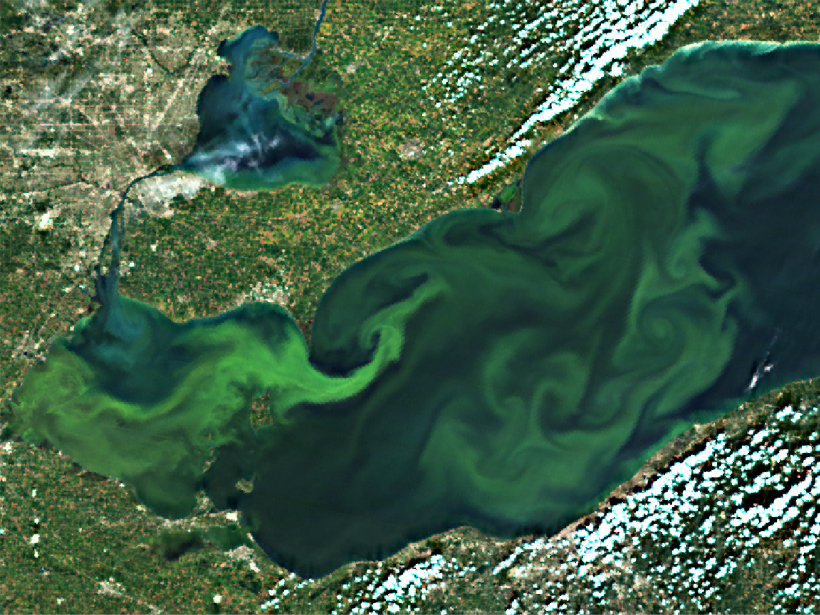
During bloom events, public water suppliers often need to change to more extensive treatment approaches or alternate water supplies, not only for toxin removal but also for the removal of nuisance taste and odor compounds. In some areas, severe blooms can lead to decreases in tourism and property values (Figure 2).

In addition, monitoring costs money and takes time, and results are often not available in a time frame that is relevant to management decisions. Automated detection of events based on remote sensing data has the potential to improve the quality and timing of data delivered to resource managers and the public.
Automated monitoring may lead to substantial costs savings. This project will identify costs associated with monitoring and potential savings with automated detection.
These risk reductions and cost savings can be realized only if the data are easily available in an easily understandable form for stakeholders entrusted with making environmental decisions. Ocean color satellite data are accessible to scientists but are not routinely processed and delivered to stakeholders or official users in a manner that is practical to daily life. Satellite data pushed from NOAA, NASA, and USGS to EPA will be made available for stakeholders through a mobile device platform and Web portals. Specific stakeholders have already been identified as project partners and will be involved in the project from the beginning for feedback and guidance.
Protecting the Public
At the conclusion of this project, we anticipate an increase in the applied use of remotely sensed water quality data for water quality management. We anticipate that environmental managers will be able to make better decisions using uniform satellite data products. In addition, satellite data products may augment federal, state, tribal, and municipal monitoring and research efforts.
The use of this technology has tremendous potential because the temporal and spatial coverage of the imagery can rectify the current lack of data available for many systems. Using satellite data to monitor and report blooms throughout a region or state would provide a new and powerful tool to assist in the holistic management of events that may involve significant risk to the public. Ultimately, this project will lead to more informed resource allocation decisions (e.g., focusing efforts more directly on problem areas identified by the satellites), improving preparedness for cyanobacteria blooms, helping the public become better informed, and reducing the potential for public exposure to cyanobacteria.
Acknowledgments
This project has been funded by the NASA Ocean Biology and Biogeochemistry Program under proposal 14-SMDUNSOL14-0001 and by EPA, NOAA, and USGS. The views expressed in this article are those of the authors and do not necessarily reflect the views or policies of the EPA.
References
Lunetta, R. S., et al. (2015), Evaluation of cyanobacteria cell count detection derived from MERIS imagery across the eastern USA, Remote Sens. Environ., 157, 24–34.
National Research Council (NRC) (2012), Exposure Science in the 21st Century: A Vision and a Strategy, Natl. Acad. Press, Washington, D.C.
National Research Council (NRC) (2013), Sustainability for the Nation: Resource Connection and Governance Linkages, Natl. Acad. Press, Washington, D.C.
World Health Organization (WHO) (1999), Toxic Cyanobacteria in Water: A Guide to Their Public Health Consequences, Monitoring and Management, E & FN Spon, New York.
Wynne, T. T., et al. (2013), Evolution of a cyanobacterial bloom forecast system in western Lake Erie: Development and initial evaluation, J. Great Lakes Res., 39, 90–99.
Author Information
Blake A. Schaeffer, Office of Research and Development, National Exposure Research Laboratory, U.S. Environmental Protection Agency, Research Triangle Park, N.C.; email [email protected]; Keith Loftin, Organic Geochemistry Research Laboratory, Kansas Water Science Center, U.S. Geological Survey, Lawrence, Kan.; Richard P. Stumpf, National Centers for Coastal Ocean Science, National Oceanic and Atmospheric Administration, Silver Spring, Md.; and P. Jeremy Werdell, Ocean Ecology Laboratory, NASA Goddard Space Flight Center, Greenbelt, Md.
Citation: Schaeffer, B. A., K. Loftin, R. P. Stumpf, and P. J. Werdell (2015), Agencies collaborate, develop a cyanobacteria assessment network, Eos, 96, doi:10.1029/2015EO038809. Published on 10 November 2015.
Text not subject to copyright.
Except where otherwise noted, images are subject to copyright. Any reuse without express permission from the copyright owner is prohibited.
Text not subject to copyright.
Except where otherwise noted, images are subject to copyright. Any reuse without express permission from the copyright owner is prohibited.