The cyclic amalgamation and rupture of supercontinents is one of Earth’s fundamental tectonic processes, ultimately affecting nearly every aspect of the planetary surface on which we live, from global climate to species evolution, through its control of land distribution, ocean circulation, atmospheric composition, and other factors. Continental and oceanic crust today preserves signatures of these make-and-break cycles, which have occurred several times through geologic time. But the evidence is rarely easy to interpret, leaving many questions outstanding.
For example, continents are really hard to break, and scientists are still trying to explain how they do. Models imply that plate tectonic forces alone are not strong enough to pull continents apart, so additional mechanisms must contribute. In many places where continents have broken apart, geoscientists have inferred a role for extensive magmatism. Magmas may have enabled continental breakups by heating and weakening continental tectonic plates [Buck, 2006], but it is often not clear where, when, and how much magma was involved.
Roughly 200 million years ago, the world’s most recent supercontinent, Pangea, began to rupture. The eastern North American continental margin (ENAM), stretching from Florida to Nova Scotia, offers glimpses into the conditions leading to Pangea’s demise, with records of extension (i.e., the stretching or pulling apart of rock) and magmatism frozen into the geologic structure of the current passive margin. Through extensive input from the research community, the GeoPRISMS (Geodynamic Processes at Rifting and Subducting Margins) program, a decadal initiative sponsored by the National Science Foundation, chose the ENAM as a focus site at which to investigate the role of magmatism during the initial rifting of Pangea and in subsequent rift evolution.
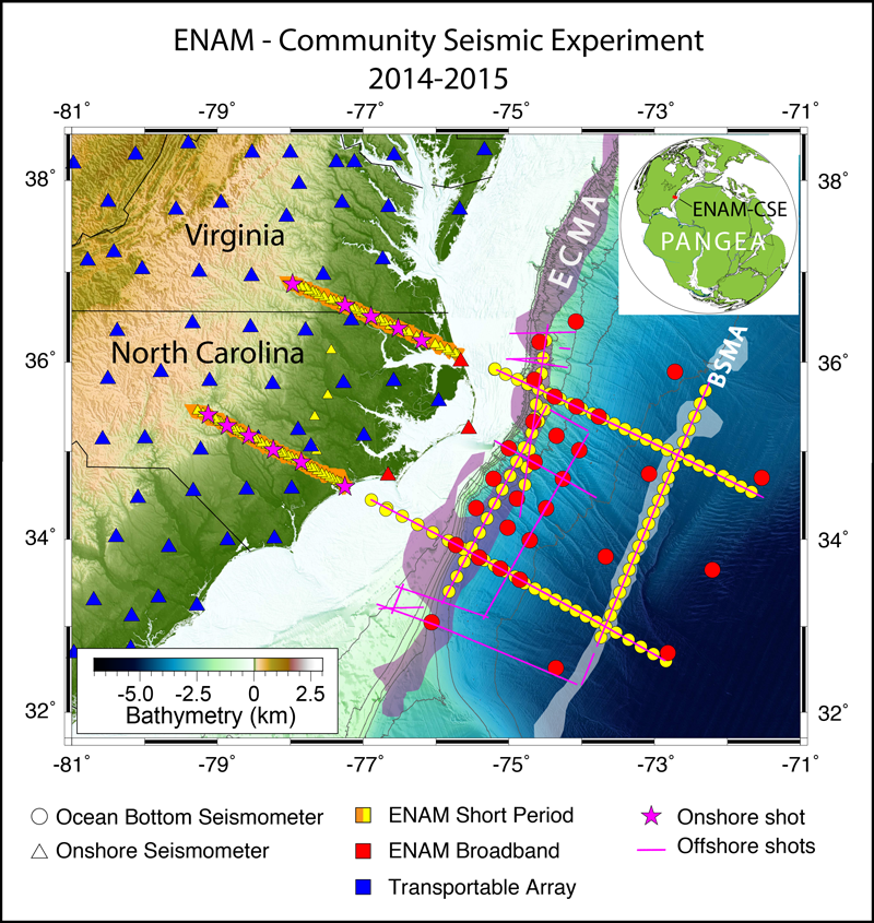
In 2014–2015, the ENAM Community Seismic Experiment (ENAM-CSE; Figure 1) [Lynner et al., 2020] provided the first immediately open data sets focused on multiscale seismic imaging over a passive margin. The CSE encompassed a roughly 500-kilometer-wide section of the margin, extending farther seaward from the North Carolina coastal plain than previous studies and offering a complete picture of the Pangean breakup. The experiment involved multiple shoreline-crossing, controlled-source seismic profiles and an array of broadband ocean bottom seismometers, allowing for high-resolution, along-margin comparisons of crust and upper mantle structure (Figure 1).
The amphibious multiscale experimental focus and open-access data arrangement have since led to a wealth of new findings related to the formation and evolution of the ENAM, forcing scientists to reconsider much of what we thought we knew about continental breakup and the formation of this passive margin.
Magmatism Splits a Supercontinent
Passive margins exist at transitions between continents and oceans where no active tectonic plate boundary occurs. Previous work has suggested that continental rifts, where landmasses split apart, and the margins they leave behind can be classified as either magma rich or magma poor. The model for magma-rich margins imagines voluminous bursts of magmatism injected into the crust, quickly weakening and eroding the existing continent and triggering breakup over a very short time frame.
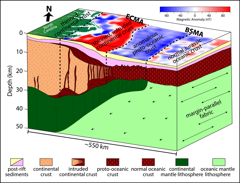
The ENAM has long been a type example of a magma-rich margin [Holbrook and Kelemen, 1993]. It is characterized by the presence of voluminous lava flows such as the Central Atlantic Magmatic Province (CAMP) and volcanic deposits that line the edge of the continental shelf, forming the East Coast Magnetic Anomaly (ECMA; Figure 2), which spans the length of the margin offshore [Greene et al., 2020]. However, new seismic and magnetic data collected during the ENAM-CSE suggest that the ENAM doesn’t entirely fit the mold of a typical magma-rich margin. Detailed computer models of the crustal structure created from these data show that magmatic intrusions into the lower continental crust during the breakup of Pangea were limited to distinct patches beneath the continental margin, rather than being widespread [Shuck et al., 2019]. And modeling of magnetic data shows that volcanism associated with the initial formation of the ECMA was emplaced over millions of years, rather than during a short pulse, and that extension rates during the earliest stages of breakup were far slower than previously estimated [Davis et al., 2018].
A short but intense magmatic event that occurred about 200 million years ago, the CAMP is the most areally extensive large igneous province recorded in Earth’s history, spreading 10 million square kilometers across the heart of Pangea, with records found in Africa, North America, and South America. This feature has long been thought of as a driving factor in continental breakup, although recent results suggest a more nuanced role. Early extension [e.g., Withjack et al., 2012] may have created the conditions for widespread decompression melting of the mantle that resulted in the CAMP [Marzen et al., 2020]. The subsequent emplacement of CAMP volcanics, in turn, then facilitated further extension and magmatism that eventually gave way to successful rifting.
A Prolonged Breakup
It is surprisingly difficult to put a finger on the timing and geographic location of the continental breakup that created the ENAM. Traditional viewpoints suggest that the ECMA marks the boundary between stretched continental crust and the earliest oceanic crust that formed after breakup and that it therefore represents the location of the continental rupture and initial seafloor spreading. Given the volcanic nature of the rift, scientists expected the CSE data to show a gradual decrease in crustal thickness seaward of the ECMA to about 7 kilometers, the average value for normal oceanic crust. Instead, the data reveal a roughly 200-kilometer-wide anomalous zone of thin and heavily faulted “proto-oceanic” crust [Bécel et al., 2020] (Figure 2). Although the crust in this region appears to be similar to normal oceanic crust, it is thinner and rougher and has faster seismic velocities [Shuck et al., 2019].
The rifting process was likely delayed because of the strong, thick lithosphere of Pangea, which long resisted intense but slow stretching forces.
Studies using the mineral content of crystallized magmas to infer ancient mantle temperatures were synthesized with seismic results to help explain this mysterious zone of igneous crust. Together these data indicate that a 15- to 20-kilometer-thick layer of lithosphere (dark green in Figure 2) acted like a lid, preventing melting of the shallow mantle. As a result, rather than quick establishment of a mid-ocean ridge that channels deep melt toward a spreading axis, diffuse melt instead percolated upward slowly throughout the stretching plate [Shuck et al., 2019]. The rough texture of the proto-oceanic upper crust and the slow rates of extension here indicated by seismic reflection imaging support this interpretation [Bécel et al., 2020].
Relatively warm mantle temperatures beneath Pangea during its breakup, inferred from petrological models and chemical signatures of CAMP basalts, show that this lithospheric lid consisted of continental rock, likely a stubborn remnant of the supercontinent. Evidently, the continental plate had not yet fully ruptured at the ECMA during formation of the anomalous region of early oceanic crust, and the battered lithosphere was hanging on by a thread.
If the current African and North American plates did not fully separate at the ECMA, when and where did they finally break apart? Another prominent magnetic anomaly, the Blake Spur Magnetic Anomaly (BSMA), marks the rapid onset of normal oceanic crust about 200 kilometers seaward of the ECMA. Findings from the CSE suggest that complete rupture of the continental lithosphere finally occurred at the BSMA, accompanied by a magmatic pulse and the initiation of normal seafloor spreading in the central Atlantic.
The rifting process was likely delayed because of the strong, thick lithosphere of the supercontinent Pangea, which long resisted the intense but slow stretching forces despite the presence of abundant magmatism. But the hot mantle asthenosphere gradually eroded the lithosphere until persistent deformation and magmatism eventually delivered the final blow. And about 168 million years ago, the fate of Pangea was set, the Atlantic Ocean was born, and Africa and North America began their slow drift apart, which continues to this day.
Active Processes on a Passive Margin
The multiscale observational focus in studies of the ENAM supported and promoted by GeoPRISMS has not only recast our views on the Mesozoic rifting of Pangea but also shed light on far more recent processes. In particular, the ENAM region hosts several active geohazards, and it appears to encapsulate more complex mantle dynamics (see Figure 2) than suggested by the research community’s previous understanding.
New seismic imaging of the shallow sediments across much of the ENAM-CSE study area indicates a high potential for submarine landslides and associated geohazards, including tsunami generation [Hill et al., 2018]. Passive margins have long been recognized as hosting significant earthquakes. Present-day crustal stresses along the ENAM are sufficient to create earthquakes with widespread shaking and damage, as demonstrated by the 2011 magnitude 5.8 earthquake in Mineral, Va. [Wolin et al., 2012]. Ongoing and active asthenospheric flow beneath the margin (both onshore and offshore) [e.g., Lynner and Bodmer, 2017], putatively driven by gradients in mantle temperature and viscosity, may exacerbate both sets of hazards by creating localized mantle upwellings and downwellings that affect surface topography and intraplate stresses.
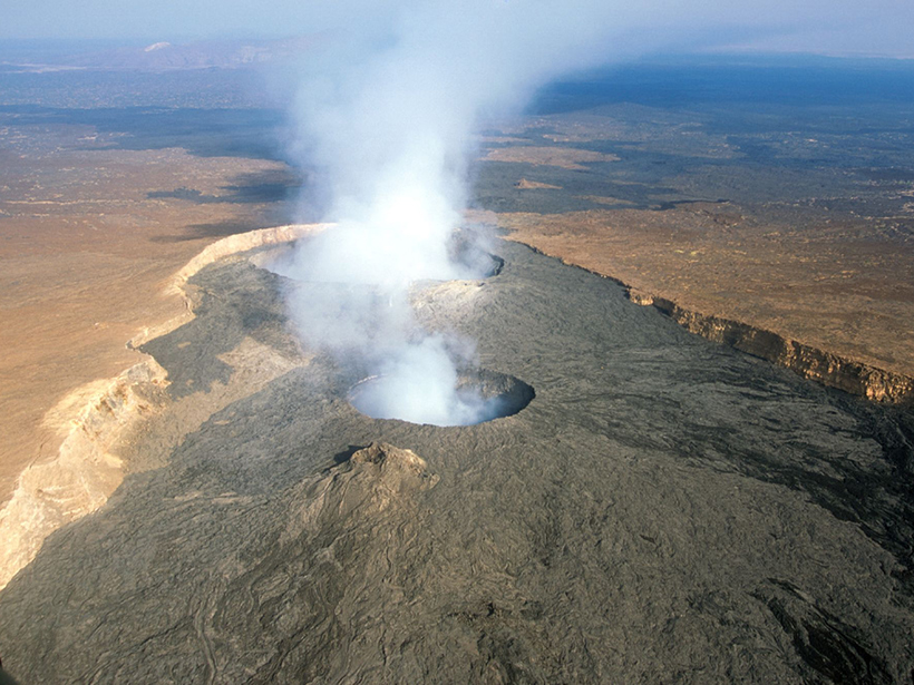
A Modern Analogue in East Africa
Our updated views of the ancient rifting of Pangea influence our understanding of the second GeoPRISMS rifting focus site, the currently active East African Rift (EAR). Often thought of as the archetypal “narrow rift,” the EAR is cited as a region where magmatism is splitting a modern continent in two.
Lessons from ENAM demand that we rethink simplistic paradigms for the ongoing breakup of the African continent.
However, lessons from the ENAM demand that we rethink simplistic paradigms for the ongoing breakup of the African continent. Current plate motions show broad extension that encompasses much of the Ethiopian plateau, well beyond the fault-bounded main rift. And new seismic data [Petruska and Eilon, 2020] from the rift flanks reveal high temperatures and, likely, mantle melt at roughly 100-kilometer depth, extending well beyond the main locus of recent (younger than 10 million years) extension.
Furthermore, ongoing EAR rifting and changes in extension rates from north (i.e., the Afar region) to south (i.e., in Kenya) allow us to see how rifting progresses episodically through time [e.g., Ebinger et al., 2013], grounding the evidence of similar waxing and waning in the rate of Pangean rifting 200 million years ago. If these dynamics persist, the EAR may provide a modern analogue to ENAM rifting, whereby continental thinning becomes widely distributed, delaying or forestalling eventual breakup.
A Formative Legacy
The impact of GeoPRISMS’s focus on rifting extends beyond the scientific accomplishments it has fostered. The program’s rifting initiative, including the ENAM-CSE, has revitalized a community of researchers by involving them in fieldwork, seminars, miniworkshops, and conferences; more than 700 attendees have attended ENAM-focused meetings, for example. Since the conclusion of the ENAM-CSE, more than 200 presentations have showcased undergraduate and graduate research conducted under the umbrella of GeoPRISMS at major national conferences, and numerous papers on the topic have been published in that time.
The GeoPRISMS program has thus not only been instrumental in driving improved understanding of a fundamental Earth process; it has also been formative for a new generation of scientists, whose professional networks and approach to collaborative research and community-driven science will carry forward into the next several decades of investigations into continental rifting.
Acknowledgments
The ENAM-CSE study area includes traditional lands and waters of many Indigenous Peoples, including the Lumbee, Skaruhreh/Tuscarora, Hatteras, Roanoke, and Chesapeake territories. We thank the captains and crews of the R/Vs Marcus G. Langseth and Endeavor, the Seismic Source Facility, the Ocean Bottom Seismograph Instrument Pool (OBSIP; now OBSIC), and all technical personnel and student volunteers for their efforts during data acquisition. We gratefully acknowledge the ENAM-CSE principal investigators: Harm van Avendonk, Donna Shillington, Beatrice Magnani, Dan Lizarralde, Brandon Dugan, Matt Hornback, Steven Harder, Anne Bécel, Jim Gaherty, Maureen Long, Gail Christeson, Lara Wagner, and Maggie Benoit. Data from the ENAM-CSE are available at the Marine Geoscience Data System. See Lynner et al. [2020] for full data set citations. EarthScope Transportable Array data are available at the IRIS (Incorporated Research Institutions for Seismology) Data Management Center (virtual network code US-TA).
References
Bécel, A., et al. (2020), Evidence for a prolonged continental breakup resulting from slow extension rates at the eastern North American volcanic rifted margin, J. Geophys. Res. Solid Earth, 125, e2020JB020093, https://doi.org/10.1029/2020JB020093.
Buck, W. R. (2006), The role of magma in the development of the Afro-Arabian Rift System, in The Afar Volcanic Province Within the East African Rift System, edited by G. Yirgu, C. J. Ebinger, and P. K. H. Maguire, Spec. Publ. Geol. Soc. London, 259, 43–54, https://doi.org/10.1144/GSL.SP.2006.259.01.05.
Davis, J. K., A. Bécel, and W. R. Buck (2018), Estimating emplacement rates for seaward-dipping reflectors associated with the US East Coast Magnetic Anomaly, Geophys. J. Int., 215(3), 1,594–1,603, https://doi.org/10.1093/gji/ggy360.
Ebinger, C. J., J. van Wijk, and D. Keir (2013), The time scales of continental rifting: Implications for global processes, in The Web of Geological Sciences: Advances, Impacts, and Interactions, edited by M. E. Bickford, Spec. Pap. Geol. Soc. Am., 500, 1–26, https://doi.org/10.1130/2013.2500(11).
Greene, J. A., M. Tominaga, and N. C. Miller (2020), Along-margin variations in breakup volcanism at the eastern North American margin, J. Geophys. Res. Solid Earth, 125, e2020JB020040, https://doi.org/10.1029/2020JB020040.
Hill, J. C., et al. (2018), Subsurface controls on the development of the Cape Fear Slide Complex, central US Atlantic Margin, Geol. Soc. Spec. Publ., 477, SP477-17, https://doi.org/10.1144/SP477.17.
Holbrook, W. S., and P. B. Kelemen (1993), Large igneous province on the US Atlantic margin and implications for magmatism during continental breakup, Nature, 364(6436), 433–436, https://doi.org/10.1038/364433a0.
Lynner, C., and M. Bodmer (2017), Mantle flow along the eastern North American margin inferred from shear wave splitting, Geology, 5(10), 867–870, https://doi.org/10.1130/G38980.1.
Lynner, C., et al. (2020), The Eastern North American Margin Community Seismic Experiment: An amphibious active- and passive-source dataset, Seismol. Res. Lett., 91(1), 533–540, https://doi.org/10.1785/0220190142.
Marzen, R. E., et al. (2020), Limited and localized magmatism in the Central Atlantic Magmatic Province, Nat. Commun., 11(1), 3397, https://doi.org/10.1038/s41467-020-17193-6.
Petruska, J., and Z. Eilon (2020), Investigation into the localization of rifting within the northern Main Ethiopian Rift using Rayleigh waves and receiver functions, paper 682297 presented at Fall Meeting 2020, AGU, agu.confex.com/agu/fm20/meetingapp.cgi/Paper/682297.
Shuck, B. D., H. J. A. Van Avendonk, and A. Bécel (2019), The role of mantle melts in the transition from rifting to seafloor spreading offshore eastern North America, Earth Planet. Sci. Lett., 525, https://doi.org/10.1016/j.epsl.2019.115756.
Withjack, M. O., R. W. Schlische, and P. E. Olsen (2012), Development of the passive margin of eastern North America, in Regional Geology and Tectonics: Phanerozoic Rift Systems and Sedimentary Basins, pp. 300–335, Elsevier, New York, https://doi.org/10.1016/B978-0-444-56356-9.00012-2.
Wolin, E., et al. (2012), Mineral, Virginia, earthquake illustrates seismicity of a passive-aggressive margin, Geophys. Res. Lett., 39, L02305, https://doi.org/10.1029/2011GL050310.
Author Information
Lindsay L. Worthington ([email protected]), University of New Mexico, Albuquerque; Brandon D. Shuck, Institute for Geophysics, University of Texas at Austin; Anne Bécel, Lamont-Doherty Earth Observatory, Columbia University, Palisades, N.Y.; Zachary C. Eilon, University of California, Santa Barbara; and Colton Lynner, University of Delaware, Newark
Citation:
Worthington, L. L.,Shuck, B. D.,Bécel, A.,Eilon, Z. C., and Lynner, C. (2021), Breaking up is hard to do, especially for continents, Eos, 102, https://doi.org/10.1029/2021EO155889. Published on 24 March 2021.
Text © 2021. The authors. CC BY-NC-ND 3.0
Except where otherwise noted, images are subject to copyright. Any reuse without express permission from the copyright owner is prohibited.