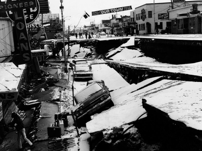
What do 1952, 1960, 1964, 2004, and 2011 have in common? In each of those years, a catastrophic subduction zone earthquake and tsunami—collectively the five largest earthquakes ever recorded—occurred somewhere around the world. Subduction zones, where one tectonic plate dives below another in fits and starts on its way into Earth’s mantle, create the largest and most destructive earthquakes and tsunamis on our planet. Revealing the dynamics of how subduction zones slip and the factors that influence them is crucial in assessing the hazards they represent.
In the time between large earthquakes, called the interseismic period, the interface between downgoing and overlying plates can become locked due to friction, accumulating stresses for hundreds of years or more, most of which will ultimately be released in future earthquakes (Figure 1). Our understanding of subduction zone slip behavior has been transformed over the past 2 decades, thanks in large part to the advent of high-precision Global Navigation Satellite Systems (GNSS; GPS is one of four GNSS systems) and other techniques from geodesy, a field focused on measuring subtle displacements of Earth’s surface. Geodetic studies enable delineation of locked portions of subducting plate interfaces in unprecedented detail and have revealed regions in many subduction zones worldwide where future large earthquakes may nucleate.
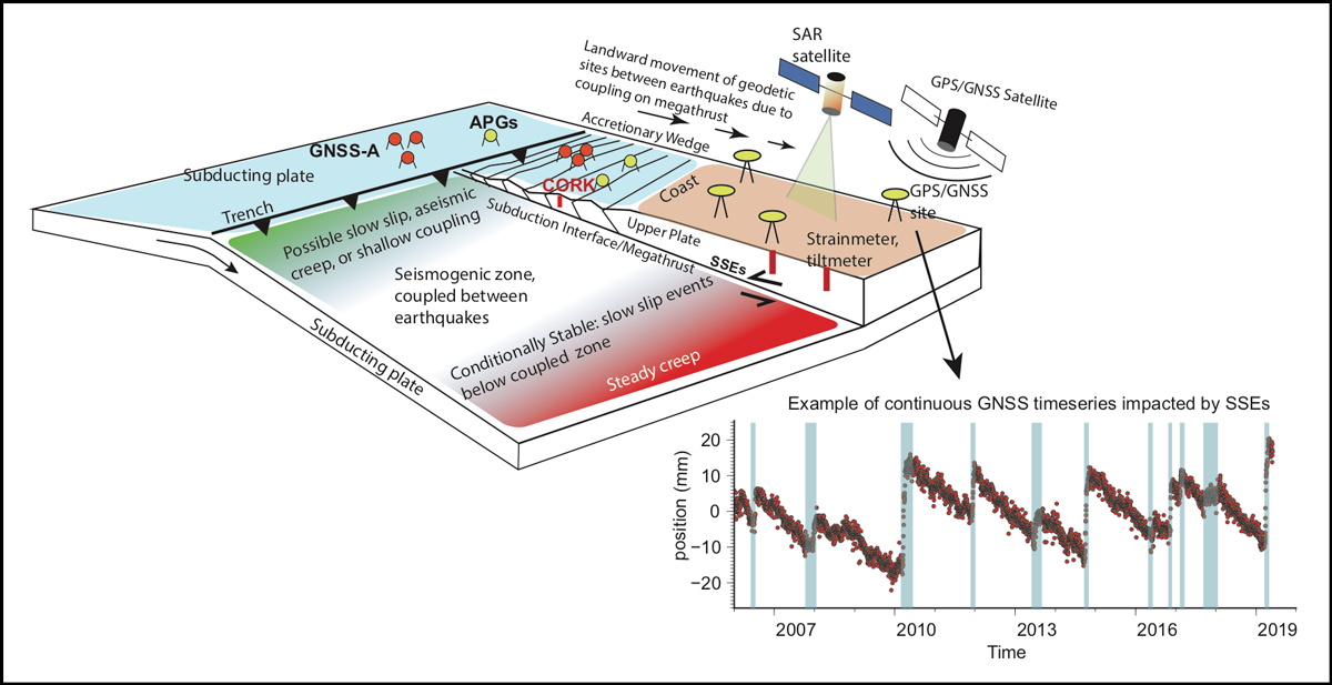
During interseismic periods, subduction zones are not static but, rather, host a variety of smaller, slow-slip events (SSEs) [Schwartz and Rokosky, 2007, and references therein], the discovery of which in the late 1990s provided a new perspective on the mechanics of subduction zones. SSEs involve a few to tens of centimeters of slip along a plate interface over days to years, rather than over the seconds to minutes timescales of regular earthquakes. Imaged using high-precision geodesy, SSEs are essentially slow-motion earthquakes that do not create damaging seismic waves or tsunamis. However, because SSEs add stress to locked fault zones, they may trigger damaging earthquakes, as has been suggested in the cases of the 2011 Tohoku-Oki earthquake in Japan and Chile’s 2014 Iquique earthquake [Ito et al., 2013; Socquet et al., 2017]. Earthquakes can also trigger SSEs, which may in turn trigger further earthquakes.
The study of slow-slip behavior is still young and we do not yet fully understand all the possible interactions between slow-slip and regular earthquakes, but recent observational advances have led to great progress. Much of this progress was spurred by the National Science Foundation’s (NSF) GeoPRISMS (Geodynamic Processes at Rifting and Subducting Margins) program (2010–2021) and its predecessor, the MARGINS program (2000–2010). Both programs supported studies of subduction zones off Costa Rica, Nankai (Japan), Cascadia, Alaska, and New Zealand. Together these locales exhibit virtually every known flavor of subduction slip behavior, megathrust locking characteristics, and subduction margin physical properties (e.g., rate of plate convergence, amount of sediment input, age of subducting plate, etc.). This variety has provided outstanding opportunities to resolve the physical processes leading to slow slip and to large megathrust earthquakes and to investigate relationships among SSEs, subduction plate interface locking, and large earthquakes.
Here we highlight examples of progress in our understanding of slip behavior at the five subduction zone focus sites of the NSF programs.
The Nankai Trough
This subduction zone off southwestern Japan has a long history of producing great earthquakes (magnitude > 8.0). Numerous Japanese-led geodetic studies have indicated that the subduction interface in the source region of past great earthquakes along the Nankai Trough is currently locked, suggesting that elastic strain accruing right now will be relieved in future megathrust earthquakes. Studies at Nankai have benefited from seafloor GNSS-Acoustic sensors that enable centimeter-level resolution of horizontal movements of the seafloor. These movements reveal the degree of shallow locking near the trench, and tracking them will inform tsunami hazard assessments in future earthquakes.
The Nankai Trough is the site of a diverse range of geodetically detected slow-slip events (SSEs), many of which are accompanied by tectonic tremor.
The Nankai Trough is also the site of a diverse range of geodetically detected SSEs, many of which are accompanied by tectonic tremor that largely occurs downdip of (i.e., deeper along the plate interface) the earthquake-producing seismogenic zone, which is locked between earthquakes (Figure 1). Tectonic tremor is a low-amplitude, long-duration seismic signal that is depleted in high-frequency energy compared with typical earthquakes. Some of these SSEs are shorter, lasting a few days to weeks, while others last a year or more [Hirose et al., 2010]. Recently, observations from instrumented seafloor boreholes revealed episodic SSEs near the trench, updip of (i.e., shallower than) the locked seismogenic zone [Araki et al., 2017]. Potential triggering relationships between these SSEs and earthquakes are not yet clear, and continuing studies—for which Japan is well equipped—will be important in establishing what, if any, relationships exist.
The Middle America Trench
This rapidly converging subduction zone is responsible for generating earthquakes of magnitude 7 and greater about every 50 years beneath the Nicoya Peninsula, Costa Rica [Protti et al., 2014]. Because of the regularity of large earthquakes here, the presence of land very close to the trench, and the presumption that the region was late in its earthquake cycle when the MARGINS program was getting under way, Costa Rica was one of the first regions chosen as a focus site for the program. With support from MARGINS, GPS/GNSS and regional seismic observations covering the Nicoya Peninsula began in 1999 and continue today. These 2 decades of instrumental coverage captured the most recent large earthquake, a magnitude 7.6 event on 5 September 2012, allowing the late interseismic period leading up to the event, as well as the coseismic and postseismic phases of the earthquake cycle, to be well recorded.
Geodetic observations during the late interseismic phase led researchers to identify a region of the plate interface that appeared frictionally locked and that subsequently matched closely with the area that ruptured during the 2012 Nicoya earthquake [e.g., Protti et al., 2014]. However, areas of the plate interface that experienced SSEs prior to the 2012 earthquake did not rupture during the main shock [Dixon et al., 2014]. If this behavior is characteristic of other subduction zones, it suggests that better monitoring of SSEs could provide valuable information for earthquake and tsunami forecasting.
Cascadia Subduction Zone
Large earthquakes occur every few hundred years in the Cascadia subduction zone, most recently in January 1700. Geodetic models broadly agree on the presence of a strongly locked zone located mainly offshore in the region where past earthquake ruptures are inferred to have occurred. How close to the surface this locking extends, which will significantly influence the size of future tsunamis, is poorly determined, thus limiting scientists’ ability to forecast hazards.
The GeoPRISMS program has enabled installation of GNSS-Acoustic sites offshore Cascadia that should soon help answer this question, delineating the updip limit of locking. Meanwhile, onshore GPS/GNSS data from southern Cascadia have revealed a newly identified phenomenon of offshore earthquakes triggering changes in plate interface locking [Materna et al., 2019], raising the possibility that plate locking varies in time, even during interseismic periods. This observation challenges the common assumption that interseismic locking is temporally steady and motivates a need to monitor locking in subduction zones for potential changes over time.
Geodetic data have also revealed that like the Nankai subduction zone, the Cascadia subduction zone features deep SSEs that are strongly associated with tectonic tremor [Rogers and Dragert, 2003]. The influence of these SSEs and tremor on the timing of large earthquakes is unclear and deserves further study.
The Alaska–Aleutian Subduction Zone
Geodetic studies have revealed strong locking in areas of the Alaska subduction zone that slipped during the 1964 earthquake.
The second-largest earthquake ever recorded, the magnitude 9.2 Prince William Sound earthquake of 1964, occurred on this subduction zone, which has since generated other events of magnitude 7–8 and greater. Geodetic studies have revealed strong locking in areas that slipped during the 1964 earthquake [e.g., Li et al., 2016; Elliott and Freymueller, 2020]. Some areas that slipped less during the 1964 event appear to be partially locked or continuously slipping today, suggesting that some locked patches may persist through multiple earthquake cycles.
SSEs also occur along the Alaska subduction zone, generally as multiyear events downdip of the locked zone, although at least some of these seemingly long SSEs may comprise bursts of multiple shorter subevents [Li et al., 2016; Rousset et al., 2019]. As with other subduction zones, the updip extent of locking is poorly resolved because of a lack of seafloor data. A recently funded GeoPRISMS project installed three seafloor GNSS-Acoustic sites, which offer improved resolution of shallow locking during the period leading up to the 2020 magnitude 7.8 Simpeonof earthquake.
The Hikurangi Subduction Zone
Onshore GNSS data sets have revealed that locking at the Hikurangi subduction zone, beneath New Zealand’s North Island, varies significantly along the subduction interface. The largest area of locking occurs beneath the capital city of Wellington and has substantial earthquake and tsunami hazard implications for residents.
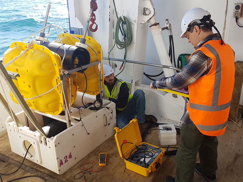
A large variety of SSEs, occurring at a range of depths and with widely varying duration, recurrence, and magnitude characteristics, have also been observed on the Hikurangi subduction zone [Wallace, 2020]. And intriguing interplays between SSEs and recent New Zealand earthquakes have been seen, including unprecedented and widespread triggering of SSEs following the 2016 magnitude 7.8 Kaikura earthquake [Wallace et al., 2018]. Absolute pressure gauges (APGs) deployed on the seafloor near the northern Hikurangi margin recorded centimeter-scale vertical deformation during these SSEs, revealing that SSEs can propagate close to the seafloor. GeoPRISMS has enabled additional deployments of GNSS-Acoustic instruments and APGs to investigate offshore SSEs and locking at Hikurangi.
Putting It All Together
A wide range of subduction slip behavior is displayed at the GeoPRISMS and MARGINS focus sites, but a few observations are common to all or most of them. Geodetically imaged fault locking has generally coincided with areas that have ruptured in the past. In the case of Costa Rica, it coincided with the eventual ruptures of then-future earthquakes. A variety of slow-slip types clearly accommodate large portions of plate motion in these subduction zones, although the details vary widely among different regions. Slow slip also typically occurs outside regions of strong fault locking; however, we cannot rule out the possibility that seismic ruptures (and tsunamigenesis) could occur in regions currently dominated by slow slip.
Addressing knowledge gaps about crustal deformation throughout the subduction earthquake cycle will require long, uninterrupted time series of data from numerous subduction zones.
Despite advances in detecting SSEs, significant gaps exist in our ability to detect smaller and shorter transient events and to reconcile seismological and geodetic observations of slip events. More widespread use of instruments like borehole tiltmeters, strainmeters, and pressure sensors is required to bridge these gaps. Recent evidence also indicates that locations of strongly locked regions may vary over time; detecting these “coupling transients” (and resolving the processes that produce them) requires improvements in data analysis and modeling techniques.
The value of seafloor geodetic sensors to resolving near-trench subduction deformation processes is now well demonstrated at MARGINS and GeoPRISMS focus sites and should be more widely applied at other subduction zones. Addressing knowledge gaps about crustal deformation throughout the subduction earthquake cycle will require long (decades and beyond), uninterrupted time series of data from numerous subduction zones, both onshore and offshore. This need underscores the importance of maintaining continuous geodetic and seismological infrastructure. It will also require that geodetic observations be further integrated with a range of other geophysical, geological, laboratory, and modeling studies.
MARGINS and GeoPRISMS have enabled great advances in our ability to observe subduction zones and to understand how they operate and the hazards they pose. Future programs should ensure continued progress in this societally important area of research and generate new discoveries about the physical processes underpinning our planet’s largest earthquake and tsunami factories.
References
Araki, E., et al. (2017), Recurring and triggered slow-slip events near the trench at the Nankai Trough subduction megathrust, Science, 356(6343), 1157–1160, https://doi.org/10.1126/science.aan3120.
Dixon, T. H., et al. (2014), Earthquake and tsunami forecasts: Relation of slow slip events to subsequent earthquake rupture, Proc. Natl. Acad. Sci. U. S. A., 111(48), 17,039–17,044, https://doi.org/10.1073/pnas.1412299111.
Elliott, J., and J. T. Freymueller (2020), A block model of present-day kinematics of Alaska and western Canada, J. Geophys. Res. Solid Earth, 125(7), e2019JB018378, https://doi.org/10.1029/2019JB018378.
Hirose, H., et al. (2010), Slow earthquakes linked along dip in the Nankai subduction zone, Science, 330(6010), 1,502, https://doi.org/10.1126/science.1197102.
Ito, Y., et al. (2013), Episodic slow slip events in the Japan subduction zone before the 2011 Tohoku-Oki earthquake, Tectonophysics, 600, 14–26, https://doi.org/10.1016/j.tecto.2012.08.022.
Li, S., J. Freymueller, and R. McCaffrey (2016), Slow slip events and time-dependent variations in locking beneath Lower Cook Inlet of the Alaska–Aleutian subduction zone, J. Geophys. Res. Solid Earth, 121(2), 1,060–1,079, https://doi.org/10.1002/2015JB012491.
Materna, K., et al. (2019), Dynamically triggered changes of plate interface coupling in southern Cascadia, Geophys. Res. Lett., 46(22), 12,890–12,899, https://doi.org/10.1029/2019GL084395.
Protti, M., et al. (2014), Nicoya earthquake rupture anticipated by geodetic measurement of the locked plate interface, Nat. Geosci., 7, 117–121, https://doi.org/10.1038/ngeo2038.
Rogers, G., and H. Dragert (2003), Episodic tremor and slip on the Cascadia subduction zone: The chatter of silent slip, Science, 300(5627), 1,942–1,943, https://doi.org/10.1126/science.1084783.
Rousset, B., et al. (2019), Weeks-long and years-long slow slip and tectonic tremor episodes on the south central Alaska megathrust, J. Geophys. Res. Solid Earth, 122(12), 13,392–13,403, https://doi.org/10.1029/2019JB018724.
Schwartz, S. Y., and J. M. Rokosky (2007), Slow slip events and seismic tremor at circum-Pacific subduction zones, Rev. Geophys., 45(3), RG3004, https://doi.org/10.1029/2006RG000208.
Socquet, A., et al. (2017), An 8 month slow slip event triggers progressive nucleation of the 2014 Chile megathrust, Geophys. Res. Lett., 44(9), 4,046–4,053, https://doi.org/10.1002/2017GL073023.
Wallace, L. M. (2020), Slow slip events in New Zealand, Annu. Rev. Earth Planet. Sci., 48, 175–203, https://doi.org/10.1146/annurev-earth-071719-055104.
Wallace, L. M., et al. (2018), Triggered slow slip and afterslip on the southern Hikurangi subduction zone following the Kaikōura earthquake, Geophys. Res. Lett., 45(10), 4,710–4,718, https://doi.org/10.1002/2018GL077385.
Author Information
Noel Bartlow ([email protected]), University of Kansas, Lawrence; Laura M. Wallace, Institute for Geophysics, University of Texas at Austin; also at GNS Science, Lower Hutt, New Zealand; Julie Elliott, Purdue University, West Lafayette, Ind.; and Susan Schwartz, University of California, Santa Cruz
Citation:
Bartlow, N.,Wallace, L. M.,Elliott, J., and Schwartz, S. (2021), Slipping and locking in Earth’s earthquake factories, Eos, 102, https://doi.org/10.1029/2021EO155885. Published on 24 March 2021.
Text © 2021. The authors. CC BY-NC-ND 3.0
Except where otherwise noted, images are subject to copyright. Any reuse without express permission from the copyright owner is prohibited.