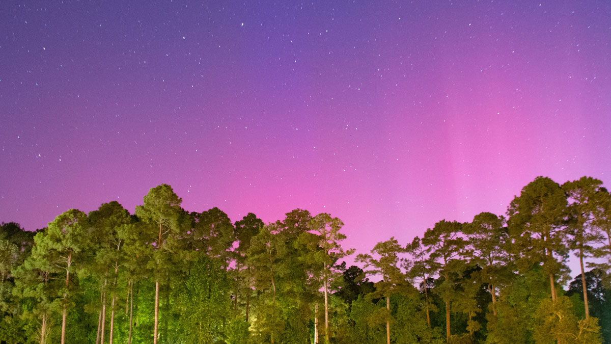
On 10–11 May 2024, the strongest solar storm since 2003 hit Earth. The storm caused spectacular aurorae around the world, including as far south as Kansas in the midwestern United States. Unfortunately, it also had negative effects, such as days-long disruptions in GPS signals needed by farm tractors that, in turn, caused delays in planting operations at a critical time in the spring.
Solar storms, which throw torrents of protons, neutrons, and other particles at our planet, have had severe effects in decades past. A massive storm in May 1967, for example, significantly disrupted military communications (and ultimately led the United States to strengthen its space weather capacity) [Knipp et al., 2016]. Another, in March 1989, disabled power grids, hitting Quebec, Canada, especially hard [Boteler, 2019].
The biggest recorded modern event took place in February 1956. Were it to be repeated today, such an event could disrupt aircraft electronics and expose passengers to substantially elevated radiation doses.
The largest known solar event in history, 50–100 times larger than the one that happened in 1956, occurred in 774 CE [Miyake et al., 2012]. An event on par with the 774 storm is considered a worst-case scenario for modern aviation [Mishev et al., 2023].
With the 11-year solar cycle approaching its maximum in 2025, we are in a time of heightened potential for such events to disrupt daily life.
Fortunately, technology for observing solar storms and the particle showers they rain down on Earth has developed significantly over the past several decades. Both ground-based and satellite observations are critical for measuring solar storms and their effects [National Academies of Sciences, Engineering, and Medicine, 2024] and for generating space weather forecasts (e.g., by NOAA’s Space Weather Prediction Center (SWPC)). The global aviation sector, for example, uses these forecasts to predict solar radiation storm warning levels and radiation dosage levels to help keep flights safe.
The small number of high-energy neutron monitoring stations used to observe the effects of solar events at Earth’s surface limits data availability and thus the accuracy and spatial resolution of forecasts.
Good predictions rely on the availability of high-quality and comprehensive data. However, the small number of high-energy neutron monitoring stations currently used to observe the effects of solar events at Earth’s surface limits data availability and thus the accuracy and spatial resolution of forecasts. But solutions are within reach.
In addition to space weather scientists, hydrologists use data from these monitoring stations, albeit for a different purpose: They rely on the high-energy neutron detections to calibrate the low-energy neutron detectors they use as one way to collect snow cover and soil moisture measurements that are important for hydrological modeling and agricultural applications. Recent studies showed that the larger networks of low-energy neutron detectors used by hydrologists can supplement and effectively increase the coverage of the smaller network of high-energy neutron monitors [Baird, 2024]. Now, scientists are devising a strategy to combine forces for their mutual benefit.
Wanted: Better Observational Capabilities
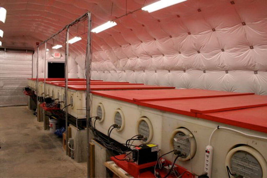
Massive lead-lined neutron monitors (NMs) are typically used to monitor the arrival of cosmic ray particles at Earth’s surface. These particles include high-energy secondary neutrons (carrying energies of ~50–100 megaelectron volts) that are generated by collisions of primary solar and galactic cosmic rays with other particles in the atmosphere, a process that can be reconstructed using NM data and numerical models [Mishev et al., 2014].
Satellites, including those in the GOES (Geostationary Operational Environmental Satellite) system, also provide operational data about primary cosmic rays in real time, but they cannot resolve particle energies in the detail required for estimating radiation doses affecting aviation or for modeling solar particle energy spectra [National Academies of Sciences, Engineering, and Medicine, 2024].
A global network of NMs, each run by different universities or other entities, has been in operation for the past 7 decades [Väisänen et al., 2021]. Unfortunately, today, only 20 NM sites around the globe provide real-time data; another roughly 30 NMs have been shut down because of a lack of long-term funding to maintain them. Geopolitical factors and closed data policies in some parts of the world additionally limit data quality and access internationally.
The U.S. Senate’s 2020 Space Weather Research and Forecasting Act emphasized the need for better observational capabilities to address this crisis of critical infrastructure. The 2020 PROSWIFT Act and the most recent National Academies’ solar and space physics decadal survey [National Academies of Sciences, Engineering, and Medicine, 2024] further underscored the challenges and need for supporting long-term operational NM networks.
Hydrologists Have Their Own Networks
Hydrologists have, in the past 15 years, deployed networks of detectors similar to neutron monitors (NMs) to measure snow and soil moisture.
Applying methods developed beginning several decades ago [e.g., Kodama et al., 1979], hydrologists have, in the past 15 years, deployed networks of detectors similar to NMs to measure snow and soil moisture [Zreda et al., 2012]. These cosmic ray neutron sensors (CRNSs) are, however, much smaller than NMs, and they are sensitive to much lower neutron energies (~0.025 to 100 kiloelectron volts).
At these lower energies, the number of detected neutrons depends not only on incoming secondary cosmic rays but also on the abundance of hydrogen in the surrounding environment (e.g., in the form of snow or soil moisture). In soil, for example, cosmic ray neutrons collide with hydrogen atoms, lose energy in the process, and become thermalized (i.e., they slow down). CRNSs are designed to count these water-sensitive neutrons.
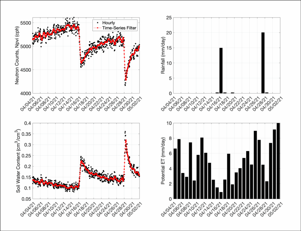
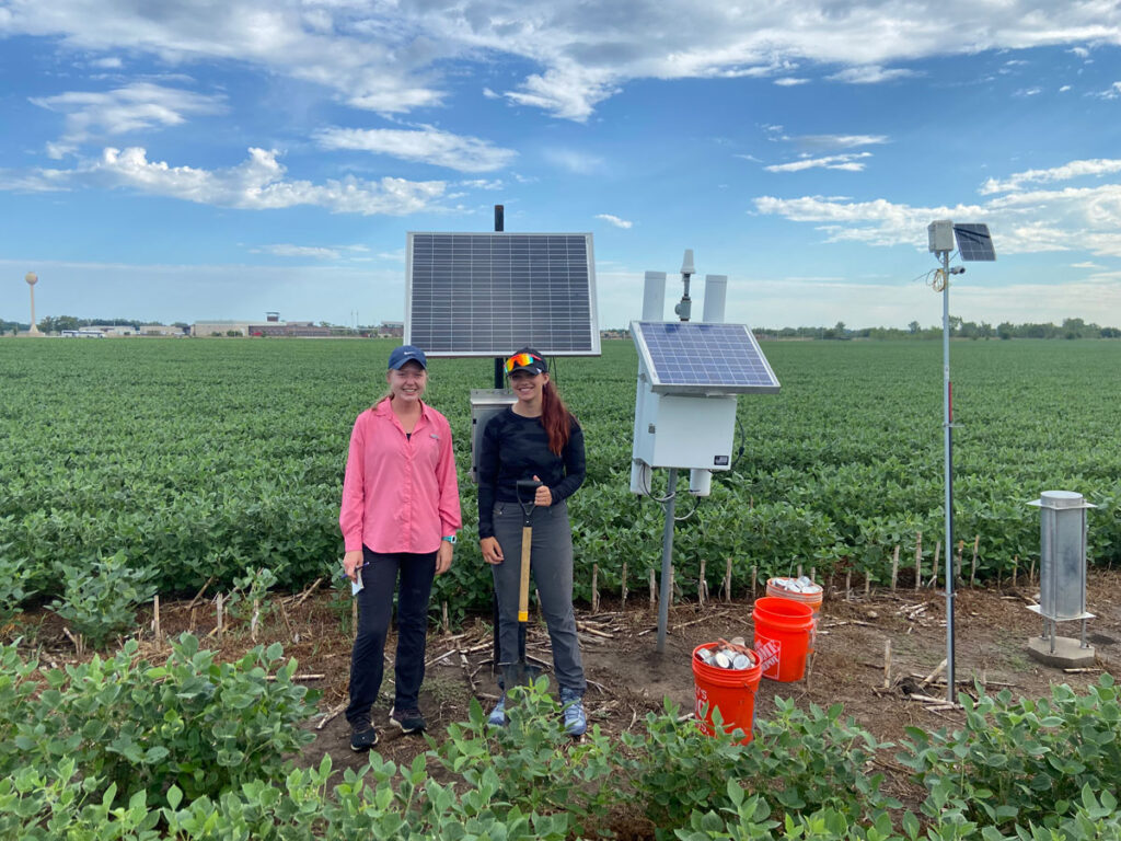
The sensors can measure these low-energy neutrons within a roughly 20-hectare circular area and up to about 30 centimeters above the ground surface, an extraordinarily large volume relative to their size. Figure 1 shows how example CRNS measurements of neutron counts and soil water content from central Nebraska clearly respond to rainfall, as measured by the local Mesonet station, and match potential evapotranspiration data well.
Area-averaged estimates of snow and soil moisture like this match scales relevant for hydrological modeling and agricultural management (e.g., irrigation and fertilizer application, crop yield prediction), providing a big advantage compared with estimates from point-scale measurements, given the high spatial variability that naturally exists from one meter to another. CRNS detectors offer other benefits as well. Their measurements, collected roughly hourly, are nondestructive; they have extremely low maintenance costs; and they can be deployed outdoors for long-term environmental monitoring.
Today, more than 300 CRNS instruments are operating across all seven continents, with networks in Australia, China, Europe, India, South Africa, the United Kingdom, and the United States. These networks have led to exciting advances in hydrology.
For example, CRNSs have been shown to be excellent sources of ground validation data for remote sensing soil moisture data products like SMAP (Soil Moisture Active Passive) and SMOS (Soil Moisture and Ocean Salinity) that support weather and agricultural forecasting efforts, among other applications [Montzka et al., 2017]. CRNS data have also been shown to significantly improve predictions of streamflow by catchment models by improving estimates of near-surface water storage [Dimitrova-Petrova et al., 2020]. Mobile CRNSs have also been deployed on commuter trains in Europe, providing soil moisture and snow observations across unprecedented scales [Schrön et al., 2021].
Despite their clear utility, CRNS networks, like the global NM network, often lack long-term funding. Moreover, in the United States, no single federal agency is mandated to monitor soil moisture, a void that hinders the development of a national coordinated soil moisture monitoring network.
An Exciting Opportunity
The CRNS research community has been highly dependent on the NM network because real-time reference data are required to correct CRNS measurements for variations in incoming cosmic radiation. In a recent advance bridging the two neutron monitoring communities, Baird [2024] showed that potential benefits also extend in the other direction.
He used 50 CRNS stations in the United Kingdom to investigate whether they can inform space weather monitoring, concluding that they “can identify persistent space weather periodicities, transient space weather periodicities, and transient aperiodic space weather signals” and that these capabilities are “largely unaffected by the influence of soil moisture in the data.” Although these identifications are not as reliable as those from neutron monitors, the much larger number of CRNSs compared with NMs offers promise for expanding data collection.
Baird also found that the CRNS data recorded some medium to large solar events, such as Forbush decreases (FDs), which are decreases in galactic cosmic rays reaching Earth following solar coronal mass ejections. The CRNSs detected 4 out of 28 FDs that had been identified by NMs between 2014 and 2022.
An exciting opportunity exists to use cosmic ray neutron sensor (CRNS) networks globally to augment the roughly 20-station NM network.
CRNS data have also been used to simulate ground level enhancements (GLEs) of radiation levels at Earth’s surface caused by bombardments of intense solar cosmic rays. These emitted particles, primarily protons, are accelerated to high energies during solar flares or coronal mass ejections. GLEs are rarer than FDs, occurring once per year on average, but are more detrimental to humans and aviation. GLEs are also nearly impossible to predict and prepare for because they arrive at Earth only minutes after a solar flare or coronal mass ejection occurs, whereas FDs take several days to arrive.
Given the newfound connection between low-energy neutron observations and space weather phenomena, an exciting opportunity exists to use CRNS networks globally to augment the roughly 20-station NM network. This ability would offer an unprecedented number of ground monitors to help researchers understand and analyze larger FD and GLE events and their impacts all around Earth.
Two Communities Join Forces
The hydrology and space weather communities have worked together informally since the 2010 launch of the Cosmic-Ray Soil Moisture Observing System in the United States [Zreda et al., 2012]. But the need for additional collaboration has been identified in the literature and during joint sessions at AGU and European Geoscience Union meetings.
In response to this increased interest, the first Coordinated Cosmic-Ray Observation System Conference was held in October 2024 at the University of Nebraska–Lincoln. The hybrid event gathered 50 experts from academia, government, and industry to explore both the scientific potential of ground-based neutron monitoring across energy spectra and opportunities for productive cross-disciplinary partnerships.
Conference participants produced a concept paper identifying key issues on which the participating communities can work together. These issues involve critical needs for improved infrastructure and enhanced data accessibility.
Documenting soil moisture conditions more comprehensively and meeting data needs for environmental modeling and operational products, for example, require the deployment of additional CRNS stations globally—ideally, 30 stations per 1 million square kilometers. In the United States, this level of coverage equates to about 250 stations spread across the country’s roughly 8 million square kilometers.
With respect to space weather, NOAA’s SWPC has stated a need for real-time NM data (1-minute resolution with 5-minute latency) and additional NM monitoring sites to improve the spatial resolution of aviation forecasts. More NM sites are also needed to better understand the anisotropy (uneven distribution) of incoming cosmic ray particles globally, particularly during GLEs and other perturbed geomagnetic conditions, and how it may influence space weather impacts experienced around the planet.
By collaboratively addressing these and other gaps in the neutron-detecting networks used for space weather and soil moisture monitoring, we can advance scientific understanding of critical environmental and planetary processes and better serve the needs of operational systems designed to foster safety and prosperity.
References
Baird, F. (2024), The potential use of hydrological neutron sensor networks for space weather monitoring, Ph.D. thesis, University of Surrey, Guildford, U.K., https://doi.org/10.15126/thesis.901065.
Boteler, D. H. (2019), A 21st century view of the March 1989 magnetic storm, Space Weather, 17(10), 1,427–1,441, https://doi.org/10.1029/2019SW002278.
Dimitrova-Petrova, K., et al. (2020), Opportunities and challenges in using catchment-scale storage estimates from cosmic ray neutron sensors for rainfall-runoff modelling, J. Hydrol., 586, 124878, https://doi.org/10.1016/j.jhydrol.2020.124878.
Knipp, D. J., et al. (2016), The May 1967 great storm and radio disruption event: Extreme space weather and extraordinary responses, Space Weather, 14(9), 614–633, https://doi.org/10.1002/2016SW001423.
Kodama, M., et al. (1979), An application of cosmic-ray neutron measurements to the determination of the snow-water equivalent, J. Hydrol., 41(1–2), 85–92, https://doi.org/10.1016/0022-1694(79)90107-0.
Mishev, A. L., L. G. Kocharov, and I. G. Usoskin (2014), Analysis of the ground level enhancement on 17 May 2012 using data from the global neutron monitor network, J. Geophys. Res. Space Phys., 119(2), 670–679, https://doi.org/10.1002/2013JA019253.
Mishev, A., S. Panovska, and I. Usoskin (2023), Assessment of the radiation risk at flight altitudes for an extreme solar particle storm of 774 AD, J. Space Weather Space Clim., 13, 22, https://doi.org/10.1051/swsc/2023020.
Miyake, F., et al. (2012), A signature of cosmic-ray increase in AD 774–775 from tree rings in Japan, Nature, 486, 240–242, https://doi.org/10.1038/nature11123.
Montzka, C., et al. (2017), Validation of spaceborne and modelled surface soil moisture products with cosmic-ray neutron probes, Remote Sens., 9(2), 103, https://doi.org/10.3390/rs9020103.
National Academies of Sciences, Engineering, and Medicine (2024), The Next Decade of Discovery in Solar and Space Physics: Exploring and Safeguarding Humanity’s Home in Space, Natl. Acad. Press, Washington, D.C., https://doi.org/10.17226/27938.
Schrön, M., et al. (2021), Neutrons on rails: Transregional monitoring of soil moisture and snow water equivalent, Geophys. Res. Lett., 48(24), e2021GL093924, https://doi.org/10.1029/2021GL093924.
Väisänen, P., I. Usoskin, and K. Mursula (2021), Seven decades of neutron monitors (1951–2019): Overview and evaluation of data sources, J. Geophys. Res. Space Phys., 126(5), e2020JA028941, https://doi.org/10.1029/2020JA028941.
Zreda, M., et al. (2012), COSMOS: The Cosmic-ray Soil Moisture Observing System, Hydrol. Earth Syst. Sci., 16, 4,079–4,099, https://doi.org/10.5194/hess-16-4079-2012.
Author Information
Trenton Franz ([email protected]), School of Natural Resources, University of Nebraska–Lincoln; Darin Desilets, Hydroinnova LLC, Albuquerque, N.M.; Martin Schrön, Helmholtz Centre for Environmental Research UFZ, Leipzig, Germany; Fraser Baird, University of Surrey, Guildford, U.K.; and David McJannet, Commonwealth Scientific and Industrial Research Organisation, Canberra, Australia