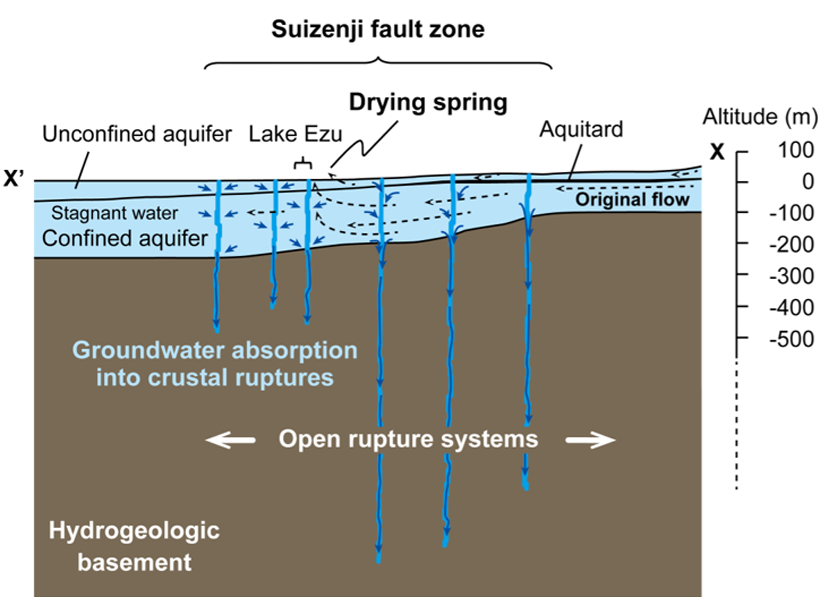
• About
  • Special Reports
  • Topics
    • Climate
    • Earth Science
    • Oceans
    • Space & Planets
    • Health & Ecosystems
    • Culture & Policy
    • Education & Careers
    • Opinions
  • Projects
    • Postcards From the Field
    • ENGAGE
    • Editors’ Highlights
    • Editors’ Vox
    • Eos en Español
    • Eos 简体中文版
    • Print Archive: 2015–2025
  • Policy Tracker
  • Blogs
    • Research & Developments
    • The Landslide Blog
  • Newsletter
  • Submit to Eos
  • AGU.org
  • Career Center
  • Join AGU
  • Give to AGU
  • About
  • Special Reports
  • Topics
    • Climate
    • Earth Science
    • Oceans
    • Space & Planets
    • Health & Ecosystems
    • Culture & Policy
    • Education & Careers
    • Opinions
  • Projects
    • Postcards From the Field
    • ENGAGE
    • Editors’ Highlights
    • Editors’ Vox
    • Eos en Español
    • Eos 简体中文版
    • Print Archive: 2015–2025
  • Policy Tracker
  • Blogs
    • Research & Developments
    • The Landslide Blog
  • Newsletter
  • Submit to Eos
Skip to content
  • AGU.org
  • Career Center
  • Join AGU
  • Give to AGU
Eos

Eos

Science News by AGU

Support Eos
Sign Up for Newsletter
  • About
  • Special Reports
  • Topics
    • Climate
    • Earth Science
    • Oceans
    • Space & Planets
    • Health & Ecosystems
    • Culture & Policy
    • Education & Careers
    • Opinions
  • Projects
    • Postcards From the Field
    • ENGAGE
    • Editors’ Highlights
    • Editors’ Vox
    • Eos en Español
    • Eos 简体中文版
    • Print Archive: 2015–2025
  • Policy Tracker
  • Blogs
    • Research & Developments
    • The Landslide Blog
  • Newsletter
  • Submit to Eos

Japan

Photo of a destroyed seawall with Japanese writing
Posted inNews

Earthquakes Shake Up Groundwater Systems

Mary Caperton Morton, Science Writer by Mary Caperton Morton 13 August 201911 May 2022

Increased permeability temporarily boosts water flow.

A map showing vertical motions in southwest Japan 7 years after the 1946 Nankai earthquake
Posted inResearch Spotlights

Déjà Vu: Understanding Subduction Zones’ Cycle of Seismicity

by Terri Cook 3 June 201918 January 2022

A unique geodetic data set from Japan’s Nankai subduction zone offers an unparalleled opportunity to study surface deformation spanning almost an entire seismic cycle.

Black-and-white aerial photo of an atomic bomb cloud
Posted inNews

Hiroshima Bomb Created Asteroid Impact–Like Glass

Lucas Joel by L. Joel 28 May 20199 May 2022

The glass rained from the sky as the bomb annihilated the Japanese city.

The Yaeyama Islands in Okinawa, Japan
Posted inResearch Spotlights

Unraveling the Origin of Slow Earthquakes

by Terri Cook 22 January 20195 October 2022

Different nucleation styles detected in five slow-slip events in the same area of Japan’s Ryukyu subduction zone suggest the physical properties along this tectonic plate interface change over time.

Crowd aerial view
Posted inNews

Next Olympics Marathon Course Has Dangerous “Hot Spots” for Spectators

Katherine Kornei, Science Writer by Katherine Kornei 18 January 201923 February 2023

Spectators’ health may be jeopardized by high heat loads along the 2020 Olympics marathon course in Tokyo, a bicycle-mounted meteorological survey found.

A wellhead used to study the tectonics and fluid flow in the submarine Nankai Trough
Posted inResearch Spotlights

In a Submarine Trough, Permeable Rocks May Lead to Quakes

Sarah Stanley, Science Writer by Sarah Stanley 29 November 20185 October 2022

In Japan’s submarine Nankai Trough, rock permeability is much higher when measured at larger scales, likely because of big fractures and faults that are not captured at small scales.

Eruption of Shinmoedake on 27 January 2011
Posted inNews

Two Active Volcanoes in Japan May Share a Magma Source

Kimberly M. S. Cartier, News Writing and Production Intern for Eos.org by Kimberly M. S. Cartier 31 July 20186 December 2021

Evidence collected following the 2011 eruption of Japan’s Shinmoedake volcano suggests that the powerful event affected the behavior of an active caldera nearby.

Earthquakes, like two that struck Kumamoto, Japan, within 28 hours in April 2016, cause varying levels of damage to buildings
Posted inNews

Damage Assessment by Laser Could Focus Postearthquake Response

by L. G. Shields 6 February 20189 December 2022

Airborne lidar surveys taken before and after a powerful 2016 earthquake in Japan revealed the potential for such surveys to identify hard-hit buildings quickly. 

Researchers examine unusual ground motion associated with the deepest major earthquake in the seismological record.
Posted inResearch Spotlights

The Curious Case of the Ultradeep 2015 Ogasawara Earthquake

by Terri Cook 28 December 20172 March 2022

Unusual ground motion associated with the deepest major earthquake in the seismological record is due to both its great depth and its origin away from the subducting slab.

Monitoring team collecting a marine sediment sample near Fukushima Daiichi.
Posted inNews

IAEA Affirms Japan’s Fukushima-Related Radioactivity Monitoring

Tim Hornyak, Science Writer by Tim Hornyak 11 October 20171 April 2024

Laboratories outside Japan have validated the results. Marine radioactivity levels from the nuclear disaster have fallen, but questions remain years after the meltdown.

Posts pagination

Newer posts 1 … 3 4 5 6 7 Older posts
Over a dark blue-green square appear the words Special Report: The State of the Science 1 Year On.

Features from AGU Publications

Research Spotlights

Making a Map to Make a Difference

11 February 202611 February 2026
Editors' Highlights

A New Way to Measure Quartz Strength at High Pressure

13 February 202612 February 2026
Editors' Vox

A Double-Edged Sword: The Global Oxychlorine Cycle on Mars

10 February 202610 February 2026
Eos logo at left; AGU logo at right

About Eos
ENGAGE
Awards
Contact

Advertise
Submit
Career Center
Sitemap

© 2026 American Geophysical Union. All rights reserved Powered by Newspack