• About
  • Sections
  • Topics
    • Climate
    • Earth Science
    • Oceans
    • Space & Planets
    • Health & Ecosystems
    • Culture & Policy
    • Education & Careers
    • Opinions
  • Projects
    • ENGAGE
    • Editors’ Highlights
    • Editors’ Vox
    • Eos en Español
    • Eos 简体中文版
    • Print Archive
  • Blogs
    • Research & Developments
    • The Landslide Blog
  • Newsletter
  • Submit to Eos
  • AGU.org
  • Career Center
  • Join AGU
  • Give to AGU
  • About
  • Sections
  • Topics
    • Climate
    • Earth Science
    • Oceans
    • Space & Planets
    • Health & Ecosystems
    • Culture & Policy
    • Education & Careers
    • Opinions
  • Projects
    • ENGAGE
    • Editors’ Highlights
    • Editors’ Vox
    • Eos en Español
    • Eos 简体中文版
    • Print Archive
  • Blogs
    • Research & Developments
    • The Landslide Blog
  • Newsletter
  • Submit to Eos
Skip to content
  • AGU.org
  • Career Center
  • Join AGU
  • Give to AGU
Eos

Eos

Science News by AGU

Support Eos
Sign Up for Newsletter
  • About
  • Sections
  • Topics
    • Climate
    • Earth Science
    • Oceans
    • Space & Planets
    • Health & Ecosystems
    • Culture & Policy
    • Education & Careers
    • Opinions
  • Projects
    • ENGAGE
    • Editors’ Highlights
    • Editors’ Vox
    • Eos en Español
    • Eos 简体中文版
    • Print Archive
  • Blogs
    • Research & Developments
    • The Landslide Blog
  • Newsletter
  • Submit to Eos

plate tectonics

Spacecraft view of the surface of Jupiter’s moon Europa showing a complex pattern of ridges and bands.
Posted inResearch Spotlights

Europa’s Plate Tectonic Activity Is Unlike Earth’s

by Morgan Rehnberg 29 November 202227 January 2023

The moon of Jupiter has likely experienced intermittent, regional plate tectonic activity in the past, although the plates are currently dormant.

2011年Tōhoku地震后日本Wakuya的鸟瞰图,显示出俯冲地震的破坏力。对太平洋俯冲带的持续重力监测有助于识别出大地震可能发生的地方。图片来源: U.S. Navy/Mass Communication Specialist 3rd Class Alexander Tidd, CC BY-NC 2.0
Posted inResearch Spotlights

东日本大地震前几个月的重力变化

Sarah Derouin, Science Writer by Sarah Derouin 25 October 202225 October 2022

研究人员利用GRACE卫星数据发现了发生在地球深部的地震事件之前的重力异常信号。

白雪覆盖的山峰排列在青藏高原的南部边缘。
Posted inResearch Spotlights

研究揭示尼泊尔西部喜马拉雅港湾状地形的形成

Sarah Derouin, Science Writer by Sarah Derouin 19 October 202219 October 2022

研究人员通过热运动学研究发现,沿着板块汇聚界面大型逆冲断层在中下部地壳深处的地壳物质堆叠塑造了高原的生长和区域水系的发育。

Three globes showing deep mantle structures in shades of red (hot structures) and blue (cold structures), with shading in each color family indicating depth. The first globe represents the mantle at 200 million years ago. The second shows the mantle at 100 million years ago. The third shows the present-day mantle. Superimposed atop the mantle structures are gray outlines of where a new model shows the continents were at each time. These globes show Asia and Australia on the left and the Pacific Ocean on the right.
Posted inNews

Billion-Year Rewind Tracks Supercontinents and Mantle Structures

by Alka Tripathy-Lang 12 October 20224 August 2023

Scientists have traced past pathways of tectonic plates back a billion years using computer models, with intriguing results. Incorporating geologic data as a check on model output, however, has proven tricky.

Tres rescatistas, vestidos en color naranja, buscan entre los escombros de un edificio caído. Detrás del edificio caído hay otro edificio de ladrillos rojos, el cual aún se encuentra de pie, pero tiene algunas paredes dañadas.
Posted inNews

¿Tienen los terremotos y las placas tectónicas una relación bidireccional?

Tim Hornyak, Science Writer by Tim Hornyak 3 October 20224 October 2022

Un terremoto catastrófico en Turquía que sucedió en 1999 cambió el movimiento de la placa de Anatolia, según un estudio que podría modificar los fundamentos de modelamiento de los terremotos.

View of a bay with buildings and vehicles in the foreground
Posted inFeatures

Seismic Sources in the Aleutian Cradle of Tsunamis

by Rob Witter, Rich Briggs, Tina Dura, Simon Engelhart and Alan Nelson 26 September 202226 September 2022

Research over the past decade in Alaska’s Aleutian Islands has offered surprising insights into the pulses of great earthquakes that generate dangerous, often long-distance tsunamis.

Photograph of a Global Seismographic Network station with mountains in the background.
Posted inEditors' Vox

Global Seismic Networks: Recording the Heartbeat of the Earth

by Adam T. Ringler 9 September 20229 September 2022

Global broadband seismographic networks have provided the science community with 30 years of data which is being used to understand the Earth.

Photo of Cerro Aconcagua, the highest mountain in the Americas
Posted inEditors' Vox

Old Igneous Rocks Hold the Key to Crustal Thickness Evolution

by Peter Luffi and Mihai Ducea 7 September 202229 September 2022

The chemical composition of orogenic igneous rocks and their zircons is sensitive to crustal thickness and can be used to quantify the evolution of Moho depths beneath continents back in time.

Three images showing the study area from different perspectives.
Posted inEditors' Highlights
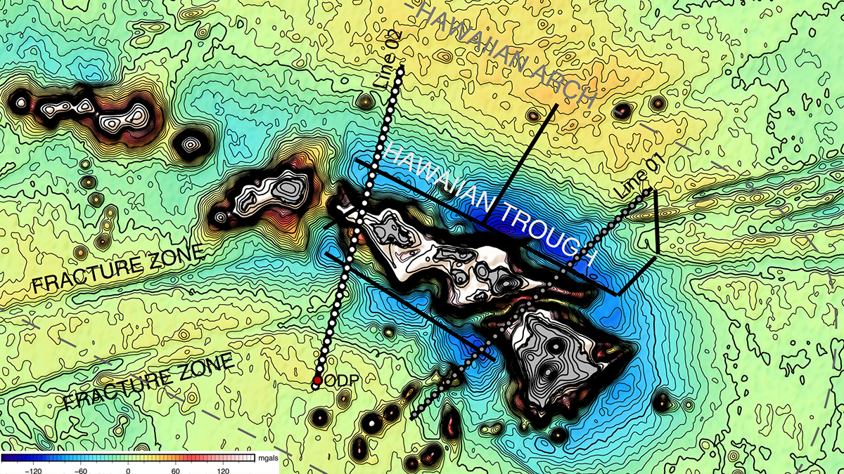
Probing the Sedimentology of a Continental Megathrust

by Peter van der Beek 6 September 202222 December 2022

Detailed analysis of sediments covering the Main Frontal Thrust in Nepal show how climate-driven baselevel changes affect sedimentation and should be considered when inferring thrust activity.

A small coastal shipping town in Japan is devastated by an earthquake. In this photo taken from a plane, the wreckage of hundreds of buildings can be seen, and only a handful remain standing. In the center of the image, a small yacht is perched on top of one of the only remaining buildings. The town is surrounded by mountains and forests. One of the plane’s wheels is visible in the lower left corner of the image.
Posted inResearch Spotlights

Months of Gravity Changes Preceded the Tōhoku Earthquake

Sarah Derouin, Science Writer by Sarah Derouin 1 September 202225 October 2022

Using GRACE satellite data, researchers discovered anomalous gravimetric signals that occurred before a seismic event that started deep within Earth.

Posts pagination

Newer posts 1 … 6 7 8 9 10 … 25 Older posts
A view of a Washington, D.C., skyline from the Potomac River at night. The Lincoln Memorial (at left) and the Washington Monument (at right) are lit against a purple sky. Over the water of the Potomac appear the text “#AGU24 coverage from Eos.”

Features from AGU Publications

Research Spotlights

What’s Changed—and What Hasn’t—Since the EPA’s Endangerment Finding

24 June 202524 June 2025
Editors' Highlights

Obtaining Local Streamflow at Any Resolution

30 June 202530 June 2025
Editors' Vox

Water Tracks: The Veins of Thawing Landscapes

25 June 202525 June 2025
Eos logo at left; AGU logo at right

About Eos
ENGAGE
Awards
Contact

Advertise
Submit
Career Center
Sitemap

© 2025 American Geophysical Union. All rights reserved Powered by Newspack