A new paper describes a rock avalanche in Greenland about 10,900 years BP that had a volume of over 1 billion cubic metres and that travelled almost 16 kilometres.

A fascinating paper (Pedersen et al. 2026) has just been published in the journal Geomorphology that describes a newly-discovered ancient rock avalanche in Greenland. This landslide, which is located in the Tupaasat Valley, is truly enormous. The authors estimate that it has a volume that exceeds 1 km3 (1 billion m3), with a runout distance of 15.8 kilometres and a vertical height difference of 1,440 metres.
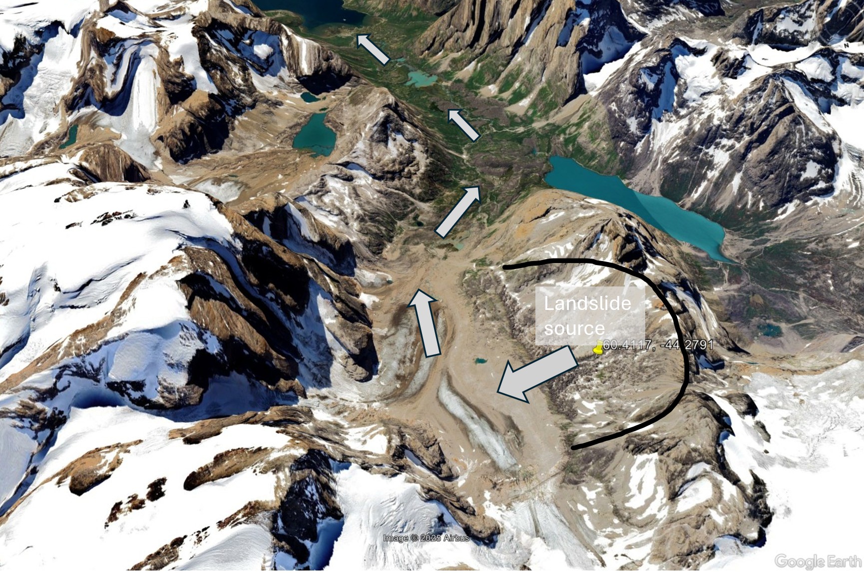
The rear scar of the landslide is located at [60.4117, -44.2791]. It is really hard to capture this landslide on Google Earth, but fortunately the paper has been published under a creative commons licence. Here, therefore, is a map of the landslide by Pedersen et al. (2026):-
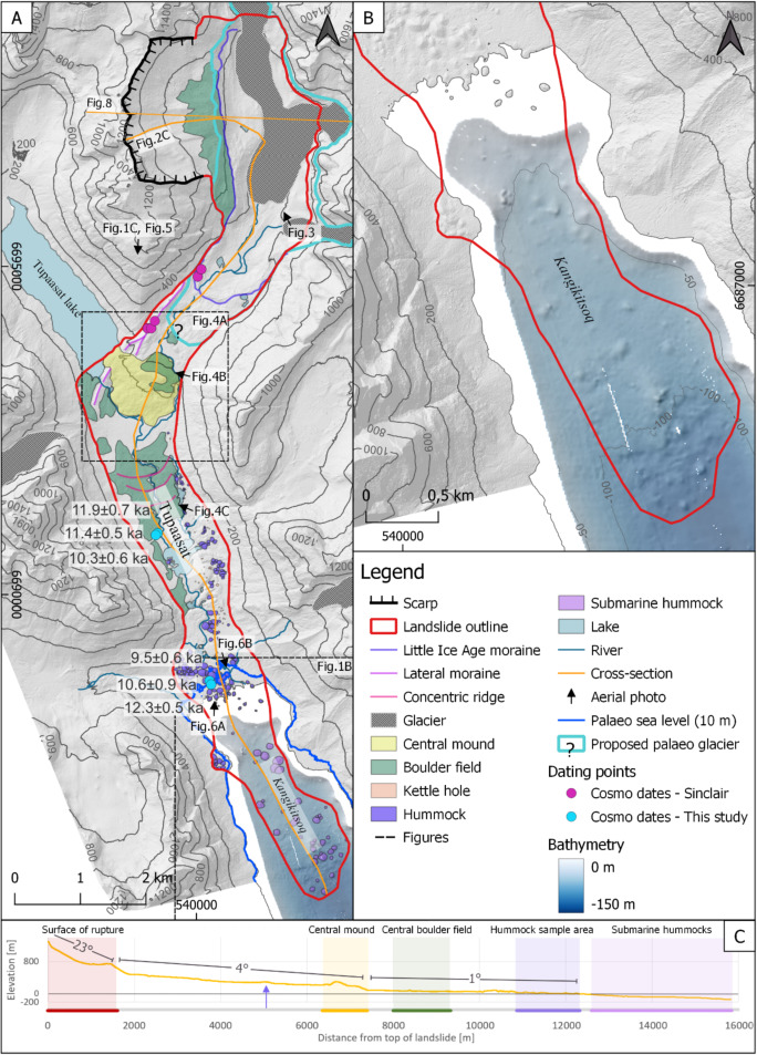
B) Map showing the bathymetry data and the landslide outline. The bathymetry data is acquired from the Danish Geodata Agency and is not suitable for navigation C) Cross-section of Tupaasat rock avalanche with columns indicating the geomorphological features described in the results. The terrain slopes are presented below.
Images from Pedersen et al. (2026).
I have quickly annotated a Google Earth image of the site, showing the source and the track of the landslide. Note that the toe extends into the fjord, and thus is underwater, by a couple of kilometres:-

Landslides on this scale are hard to fathom. If this volume of rock was standing on a standard American football field (110 m x 49 m) it would form a column 185.5 km tall.
Pedersen et al. (2026) have dated the time of occurrence of this landslide. They conclude that it occurred about 10,900 years ago. This coincides remarkably well with the dated deglaciation (retreat of the icesheets) in this area. Thus, the authors suggest that the instability was probably associated with debuttressing of the glacier (i.e. the removal of the ice adjacent to the slope. They cannot rule out the possibility that final failure might have been triggered by an earthquake, though.
A further intriguing question is whether the event triggered a tsunami in the fjord. The distance that the landslide has moved suggests that it was very energetic. Given that it extended to the water (and some of the deposit is now within the lake) it is extremely likely that a displacement wave was triggered.
The latter point is very pertinent as there is increasing concern about the dangers of giant rock slope failures generating damaging tsunami events in fjords. For example, CNN published an article this week in the aftermath of the Tracy Arm landslide and tsunami that highlights the risk to cruise ships. It notes that:
Alaska’s foremost expert on these landslides knows why there hasn’t been a deadly landslide-turn-tsunami disaster, yet: sheer luck.
“It’s not because this isn’t a hazard,” said geologist Bretwood Higman, co-founder and executive director of nonprofit Ground Truth Alaska. “It’s because it just hasn’t happened to be above someone’s house or next to a cruise ship.”
An additional piece of context is the remarkable flooding that occurred in Alaska last weekend as Typhoon Halong tracked across parts of the state. This appears to have received far less attention than might have been anticipated, at least outside the US.
It is surely only a matter of time before we see a really large-scale accident as a result of a tsunami triggered by a rock slope failure. A vey serious scenario is that a large cruise ship is overwhelmed and sunk. The loss of life could be very high.
Reference
L.L. Pedersen et al. 2026. A giant Early Holocene tsunamigenic rock-ice avalanche in South Greenland preconditioned by glacial debuttressing. Geomorphology, 492, 110057,
https://doi.org/10.1016/j.geomorph.2025.110057.