Alongside the human casualties and the destruction of homes and infrastructure, the war has brought the widespread destruction of arable land. Agriculture comprised 32% of land use in Gaza before 7 October 2023, when Hamas attacked Israeli communities in the country’s Gaza Envelope and Israel launched a massive military response.
A recent analysis has tracked the destruction of tree cropland and greenhouses in Gaza since the start of the war. The analysis revealed that 70% of tree cropland and 58% of greenhouses were damaged or destroyed in the first year of the conflict. By the end of October 2025, 98% of Gaza’s tree cropland had been destroyed. Ninety percent of greenhouses were damaged, and 75% were destroyed.
“Now, after 2 years, we see that most of the greenhouses are gone and the remaining tree cover is largely gone,” said Mazin Qumsiyeh, a biologist and social justice advocate at Bethlehem University in the West Bank and a researcher on the project. His opinion is that Gaza has endured an ecocide of agricultural lands over the past 2 years.
“This is unprecedented damage,” said He Yin, a geographer and remote sensing researcher at Kent State University in Ohio and lead researcher on the project. “I have never seen anything like this,” said Yin, who previously studied other areas of armed conflict, including Syria and the northern Caucasus. Gaza, he said, has “become like a barren land.”
Gazan Agriculture Before the War
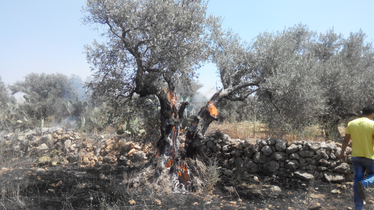
Farmers have been cultivating crops in Gaza and the surrounding land for thousands of years. Olive trees, in particular, have played an important cultural role throughout Palestinian and Israeli history, featuring prominently in celebrations, art, literature, and religion.
Prior to October 2023, Gaza’s agricultural sector made up 11% of the territory’s gross domestic product (roughly $575 million) and 45% of its exports. Farmers in the region cultivated olive and citrus trees, as well as grapes, guava, dates, palms, and figs. More delicate fruits, vegetables, and flowers were grown in tunnels or other protective structures like greenhouses.
“Gaza was not self-sufficient in foods, but [it] did produce significant number of products,” Qumsiyeh said. Despite some reports of blocking rainwater harvesting and severely restricting access to a shared aquifer, “like everything else in Gaza, people managed and survived and resisted and did agriculture,” he said.
The agricultural sector contributed to Palestinians’ food and economic security. Of Gaza’s 365 square kilometers of land, roughly 32% of it was used to grow food, mostly on small-scale family farms. Tree crops covered 23% of the Gaza Strip. Exports like olive oil, strawberries, and flowers found purchase in high-income markets across Europe, Qumsiyeh said, as well as the West Bank. And in years with enhanced drought or poor harvests, selling high-quality, shelf-stable products like olive oil could provide for a family in need.
Now, after 2 years of war, most agricultural land has been destroyed. Pinning down where, when, and how that happened is necessary for recovery and remediation, explained Najat Aoun Saliba, an atmospheric chemist at the American University of Beirut in Lebanon.
Saliba, also a member of Lebanon’s parliament, has studied the impacts of war-related pollutants on public and environmental health in Lebanon but was not involved with the new research about Gaza. Israel has used many of the same types of munitions in cross-border strikes in southern Lebanon, and Saliba suspects that the long-term environmental damage in Gaza might mirror what she has seen in her own country.
“The long-term environmental impacts of munitions include persistent heavy-metal and explosive residue contamination; persistent phosphorous materials that were used heavily at least in southern Lebanon; [unconfirmed] presence of radioactive materials…especially in the bunker buster ammunitions; reduced soil fertility and microbial imbalance; groundwater pollution and loss of irrigation capacity; and heightened erosion and desertification risks,” Saliba said.
Tracking the Destruction
The United Nations Satellite Center (UNOSAT) has been remotely monitoring the destruction of buildings, land, and infrastructure in Gaza since the start of the war. Their monthly agricultural damage assessments have shown widespread damage, but their methodology has some limitations when applied to a region as small as Gaza, Yin explained.
UNOSAT relies on data from the Sentinel-2 satellite, which has a nominal spatial resolution of 10 meters; that might not be the best choice for monitoring Gaza’s small-scale and sometimes fragmented agricultural land. What’s more, in such a rapidly evolving conflict, a monthly observing cadence is not able to track the progression of damage or trace the destruction of individual plots to specific military actions.
To overcome those challenges, Yin and his team turned to two commercial satellite data sources with higher spatial resolutions and daily monitoring: PlanetScope, with a nominal 3-meter resolution, and SkySat, with a nominal 50-centimeter resolution. The higher-resolution datasets allowed the team to create detailed land use maps of Gaza before October 2023, including tree cropland and greenhouses, and then track partial damage or total destruction of those plots every day since Israel’s war commenced.
The researchers compared their damage maps to UNOSAT’s to validate their technique. They further validated their remote sensing results by consulting with Yaser Al A’wdat from the Palestine Ministry of Agriculture in Gaza and with other individuals on the ground, who checked whether certain areas flagged in the analysis as “destroyed” truly were. Those consultants in Gaza declined to be interviewed for this story out of concern for their safety.
The initial analysis covered the destruction of agricultural land through the first year of the war and was published in Science of Remote Sensing in 2025. The researchers found that 64%–70% of tree crop fields and 58% of greenhouses had been damaged by the end of September 2024, after almost 1 year of war. By the end of 2023, all greenhouses in the North Gaza and Gaza City governorates had been damaged, as well as nearly all greenhouses in the Gazan governorate of Deir al-Balah. The analysis showed how damage to both cropland and greenhouses progressed southward toward Khan Yunis and Rafah as Israel’s military campaign shifted focus.
The team continued its analysis through the second full year of the war, and those results, which will be presented on 18 December at AGU’s Annual Meeting 2025 in New Orleans, reveal the near-total destruction of tree cropland (98%) and increasing damage to greenhouses (90% damaged and 75% destroyed). Greenhouses in Rafah, in particular, suffered extensive and widespread damage as the conflict advanced south.
Remediate, Replant, Restore
Although a shaky (and repeatedly violated) ceasefire went into effect on 10 October, restoration and remediation will take time and very careful planning.
“Research like this can play a critical role in restoration and recovery efforts in Gaza by providing an evidence-based foundation for agricultural rehabilitation,” Saliba said.
“This type of spatial assessment allows policymakers and humanitarian agencies to plan sequenced restoration—starting with fast-growing crops before replanting long-term trees like olives and citrus—and to design targeted compensation and replanting programs based on verified damage maps,” she added.
Future analyses seeking to map the scope of agricultural damage, as well as efforts to remediate that damage, should incorporate the food-energy-water nexus, Saliba said. “Because no agriculture restoration could happen without providing water.”
As focus turns toward restoration, the first thing that is needed are data, Qumsiyeh said. “For example, we don’t know the extent of soil contamination in Gaza and what residues of war are there, whether depleted uranium or white phosphorus or heavy metals and other things,” he said. “We don’t even have access to get the soil samples out of Gaza.”
There is also increased concern about aquifer contamination. Because tunnels built by Hamas were subsequently flooded with seawater by Israel, some of that water undoubtedly seeped through the ground into the aquifer that supplies most of the territory. In addition, Gaza has now seen three rainy seasons since the start of the war.
“All of that water from the rain will wash these pollutants from the soil down into the water aquifer,” Qumsiyeh said. “Again, we don’t have the data because we don’t have samples of water from the water aquifer to be able to test.”
Qumsiyeh offered the opinion that stronger international laws related to ecocide could increase accountability.
At present, Israeli troops have partially retreated from the territory, but the area they still occupy beyond the so-called Yellow Line comprises much of Gaza’s agricultural land and is inaccessible to Palestinian farmers. According to the United Nations Office for the Coordination of Humanitarian Affairs, Israel continues to block the entry of agricultural inputs like seed kits, organic fertilizers, and materials needed to rebuild greenhouses.
“Agriculture is part of life. We are part of the land,” Yin said. Ultimately, “who has the power to rebuild Gaza really matters.”
9 February 2026: Descriptions regarding the conflict have been updated throughout the article by AGU. The byline has been removed at the request of the author and editor.
8 January 2026: This article has been updated to clarify the location of the 7 October attacks.