The shape and position of Earth are constantly changing. Geodesy is the branch of geophysics that studies these properties—our planet’s size, orientation, and gravity—which are crucial for answering important Earth and space sciences questions: How will sea levels rise in the coming decade? What are the precise orbits of satellites? What are the patterns in a volcano’s magma migration? How is elevation determined? Pursuing these questions requires maintenance and improvement of the geodetic infrastructure—the instruments, software, and expertise that provide precise measurements.
“It’s like a freeway system…it’s really fundamental.”
“It’s like a freeway system or something—it’s really fundamental,” said David Sandwell, a marine geophysicist at Scripps Institution of Oceanography in San Diego. Sandwell chaired the committee behind a report addressing geodetic infrastructure, released in 2020 by the National Academies of Sciences, Engineering, and Medicine (NASEM). The report provides recommendations to ensure that researchers will be able to continue using geodetic approaches to tackle diverse Earth science questions, from sea level change to weather models to geological hazards. These research areas were highlighted in an earlier decadal survey funded by NASA, NOAA, and the U.S. Geological Survey (USGS).
Terrestrial Reference Frame
The primary need for the geodetic infrastructure is to define a terrestrial reference frame, a set of 3D coordinates organized around Earth’s center of mass. The more correct this reference frame is, the more accurate and stable satellite orbits are. This accuracy provides scientists with better data sets.
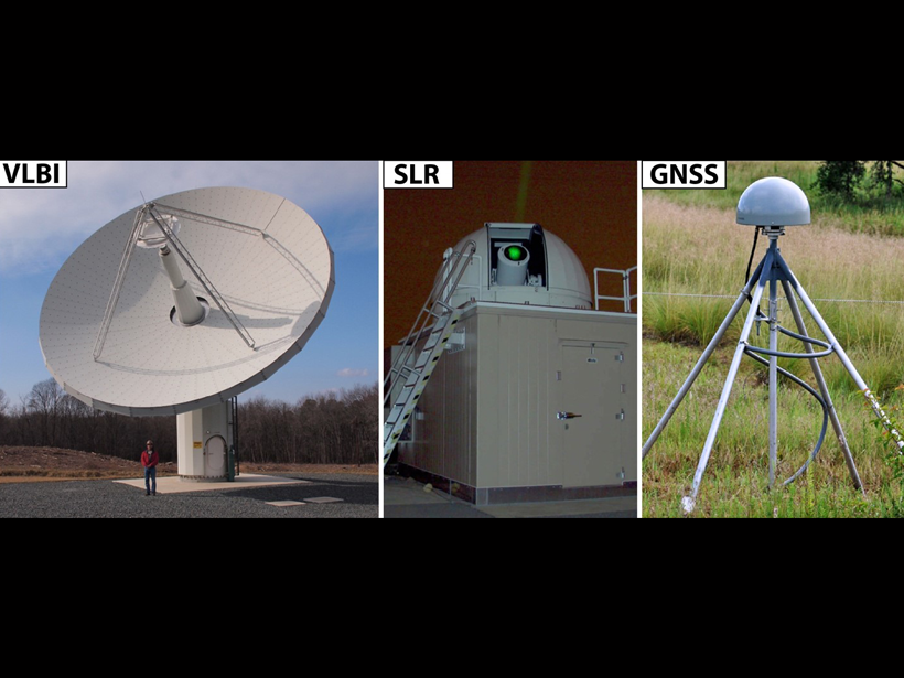
The terrestrial reference frame relies on four techniques. Very long baseline interferometry (VLBI) measures radio signals from distant quasars to measure Earth’s orientation in space and scale. Satellite laser ranging (SLR) relies on short pulses sent to satellites; the return times can be used to trace satellite orbits and calculate Earth’s center of mass and scale. The Global Navigation Satellite System (GNSS), which includes GPS, and the Doppler Orbitography by Radiopositioning Integrated on Satellite (DORIS) system provide additional global measurements. Raw data from these systems are combined and analyzed to produce the International Terrestrial Reference Frame (ITRF). The ITRF is a group effort, the report describes: “All parties involved work in an open international collaborative environment to provide the most accurate reference frame for science and applications.”
The report recommends the deployment of more VLBI and SLR stations and the establishment of more receivers that can interface multiple GNSS systems. Such improvements would provide more coverage and improve the accuracy and stability of the terrestrial reference frame.
Geodetic infrastructure like this is critical for determining the precise orbits of satellites described in the decadal survey, said Shin-Chan Han, a geodesist at the University of Newcastle in Australia. “Such precise orbit is mandatory to achieve all the identified important science problems,” he said. Han reviewed the NASEM report but wasn’t directly involved in its preparation.
Monitoring Land Subsidence
Geodetic infrastructure is also crucial in hydrology. GPS and interferometric synthetic aperture radar (InSAR), a satellite-based technique for measuring land deformation, have transformed how scientists study land elevation changes due to groundwater removal and recharge.
“I just can’t imagine waking up one morning and saying, oh, the GPS constellation isn’t working anymore,” said Michelle Sneed, a USGS hydrologist who was part of the committee that authored the NASEM report. One area that Sneed monitors is the San Joaquin Valley, an agriculture region in central California that has changed dramatically because of groundwater pumping for irrigation. From 1925 to 1977, the land surface in this area subsided about 9 meters because of compaction. Sneed and colleagues used continuous GPS and InSAR to assess land subsidence in the west central San Joaquin Valley and explored potential risks to the California Aqueduct.
The techniques also indicated that Coachella Valley has stabilized, likely because of projects that increased recharge and reduced reliance on groundwater. “The integration of these different geodetic techniques…adds different pieces to the stories,” Sneed said. “InSAR is this great spatial tool. But if you want a daily value of the land surface at any one point, then you need continuous GPS.”
Additional Infrastructure
Maintaining geodetic infrastructure faces significant challenges, the NASEM report notes. Making the software for processing raw geodetic data widely available is one such challenge, and compensating for an aging workforce is another. “I’m concerned about a shortage [in the] geodesy workforce,” Han said.
Maintenance and enhancement of geodetic infrastructure will be crucial for addressing the Earth science questions outlined in the decadal survey. As described in the report, “the international geodetic infrastructure is the largely invisible foundation of Earth system science and applications.”
—Jack Lee (@jackjlee), Science Writer
Citation:
Lee, J. (2021), Evolving the geodetic infrastructure, Eos, 102, https://doi.org/10.1029/2021EO161271. Published on 28 July 2021.
Text © 2021. The authors. CC BY-NC-ND 3.0
Except where otherwise noted, images are subject to copyright. Any reuse without express permission from the copyright owner is prohibited.