For nearly 2 decades, Nikki Noushkam’s house in Rancho Palos Verdes was solid. “There was not a hairline crack,” said Noushkam, a space sensing program manager who moved to the Southern California city in 2005. But everything changed last year, she said, when the ground underneath her community began sliding toward the Pacific Ocean.
Rancho Palos Verdes is caught in a series of slow-moving landslides that are wreaking havoc in this coastal community—roads are buckling, utilities are being shut off, and some people have been forced to leave their homes. “The house across the street from me had been red tagged,” Noushkam said.
She and others in her community are looking for answers. “The uncertainty of not knowing what’s going to happen and not having a solution to this problem is what really worries me,” she said.
Throwing Weight on a Problem
Situated roughly 25 miles (40 kilometers) south of Los Angeles, on the Palos Verdes Peninsula, Rancho Palos Verdes is known for its unobstructed views of the Pacific Ocean. But the bluffs that afford those panoramic vistas are inherently fragile—they’re made of shale, a sedimentary rock. “Shale is an extremely weak material,” said Ben Leshchinsky, a civil engineer at Oregon State University in Corvallis. “When it starts to move, it loses a lot of strength.”
And move it did in the 1950s, when the County of Los Angeles trucked in more than 160,000 metric tons of fill to extend Crenshaw Boulevard, a major thoroughfare. All that extra weight destabilized an area that was probably already precarious, said Joe Wartman, a geotechnical engineer at the University of Washington in Seattle. By 1956, the ground in the Portuguese Bend neighborhood of Rancho Palos Verdes was sliding up to several centimeters per day to the west. More than 150 homes were destroyed or severely damaged over the next few years.
Landslide activity in Rancho Palos Verdes then largely abated, however, and the region enjoyed a development boon. The aerospace industry flourished across Southern California, and model homes soon dotted the city’s gently sloping hills.
But in recent years, there’s been a pronounced uptick in landslide activity. “It’s definitely moving much faster now than it has been in recent history,” said Alexander Handwerger, a landslide scientist at NASA’s Jet Propulsion Laboratory in Pasadena, Calif.
Follow the Water
“Those back-to-back wet years caused the majority of this big acceleration that we’ve seen.”
The culprit, most researchers believe, is water underground: Record-setting levels of rain fell over much of California in 2022 and 2023. As all that precipitation infiltrated into the ground, it raised the water table. Subsurface water exerts pressure upward and can predispose the ground to moving. “Those back-to-back wet years caused the majority of this big acceleration that we’ve seen,” said Mike Phipps, a geologist employed by the consulting firm Cotton, Shires and Associates Inc. and a contractor for the city of Rancho Palos Verdes.
City officials have been tracking ground movement in Rancho Palos Verdes using more than 120 GPS stations. Since 2007, Michael McGee, a Professional Land Surveyor contracted by the city, has been tabulating those data. They reveal that landslide activity peaked in May and June of this year, when the ground moved more than 12 inches (25 centimeters) each week. “We used to measure three times per year,” McGee said. “Now that it’s moving 4 or 5 feet [1.2–1.5 meters] per month, we measure some of the points once a week.”
“What we’re dealing with now is an area of close to 700 acres.”
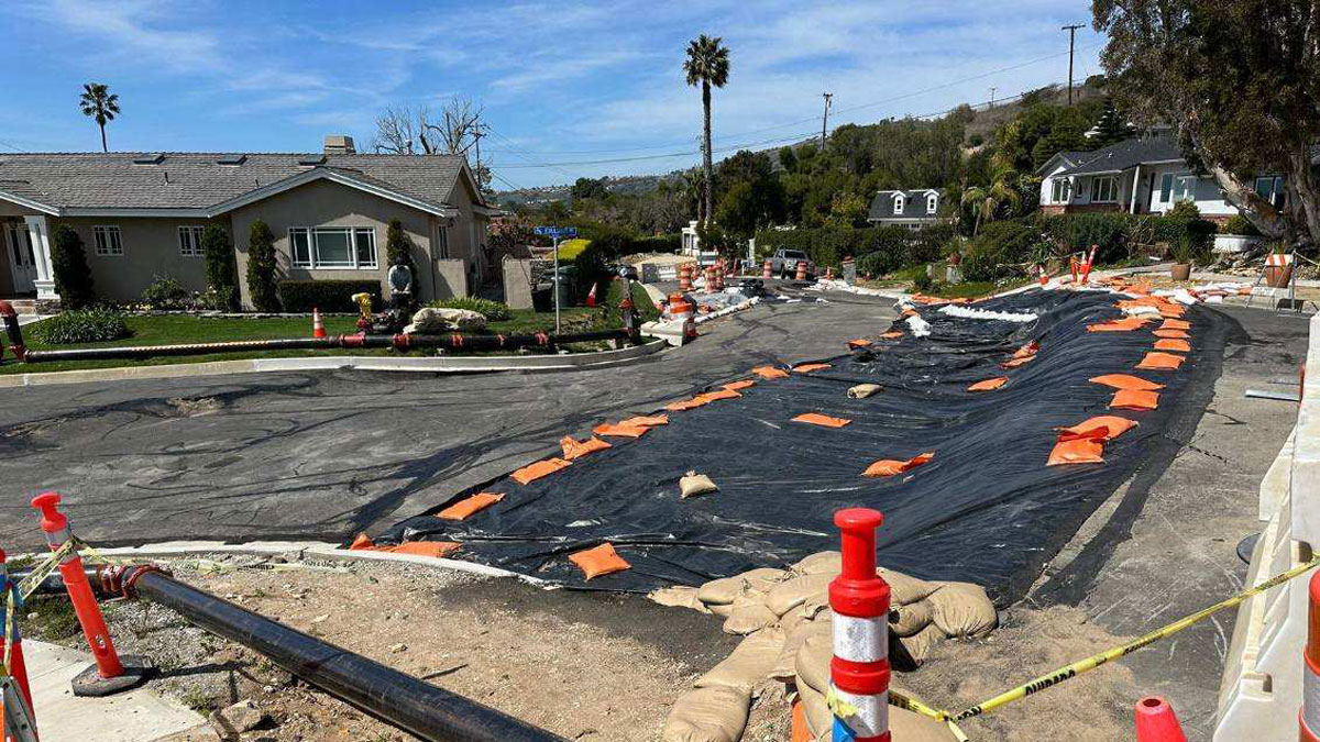
Activity has subsided somewhat since then, but getting water out of the ground is still critical, said Phipps. Last month, crews were installing the third of five planned dewatering wells near the beach. Each of those wells extends down below the deepest part of the landslide and has a pump to remove water. The two existing wells are each pumping out about 130,000 gallons (nearly 500,000 liters) of water per day. But because the ground is still moving relatively rapidly, it’s necessary to redrill the wells each week, Phipps said. “The land is moving so fast that a 10-inch-diameter [25-centimeter] hole is going to close off in about 7 days.”
Curbing the current ground movement will be challenging, Phipps said. That’s because the downslope portion of several of the active landslides—that is, their toe—sits at the ocean. There’s accordingly no barrier in front of the sliding ground, and the toe is furthermore subject to erosion by waves.
There’s also the sheer size of the total sliding area, which has increased by roughly twofold in recent decades, Phipps said. “What we’re dealing with now is an area of close to 700 acres [280 hectares].”
A 3D View
To better understand where and how the ground is shifting, city officials are considering proposals to survey not only the ground surface but also the nearshore seafloor using a technique known as light detection and ranging (lidar). Lidar surveys are commonly conducted from an aerial platform such as a drone or small plane. Large areas can therefore be surveyed efficiently, which is a strength in the case of Rancho Palos Verdes, Handwerger said. “Because of the sheer size of the landslide, it’s hard to cover the whole area with GPS.”
There’s also an intrinsic advantage of lidar over GPS surveying. You end up with a cloud of millions or even billions of measurements in 3D space, said Jonathan Perkins, a geologist at the U.S. Geological Survey. “You can measure surface displacement at very high spatial resolution.”
Getting a closer look at how the ground is shifting in Rancho Palos Verdes would be valuable because of the complexity of the landsliding there, Wartman said. “There are a few nested landslides. It’s not just one large mass movement.” A high-resolution survey of the region could furthermore help reveal areas whose movements are connected, he said. “Often what we see with landslides of this size is that one part moves, and something else moves in response.” Understanding those linkages could shed light on what’s happening deep underground, which could inform mitigation strategies.
In addition to dedicated surveys of the Rancho Palos Verdes area, data collected for other projects might provide new insights as well. For example, Handwerger is involved in a project led by NASA’s Jet Propulsion Laboratory that will produce a data set of land surface displacements across North America. Those measurements, which are based on Sentinel-1 satellite data and are slated to be released in December, could be useful to Rancho Palos Verdes officials, Handwerger said.
“We’re asking for help wherever we can get it.”
Sentinel-1 satellites pass over the same swath of land roughly every 6 days, so this data set provides a high-temporal-resolution look at surface displacements. That’s important in cases like Rancho Palos Verdes, he said. “One of the applications, among many others, is that people could be using this to monitor landslides.”
Those data, and others like them, can’t come too soon, said Mark Young, a general contractor who lives in the Seaview neighborhood of Rancho Palos Verdes. Young’s electricity and gas were recently shut off, but he’s hoping to remain in his house for as long as possible.
Young remembers seeing images compiled from interferometric synthetic aperture radar (InSAR) data from the deadly Oso, Wash., landslide that occurred in 2014. He and other residents have wondered whether similar data could be collected in their community. “We’re asking for help wherever we can get it,” said Young. Noushkam echoed that sentiment. “I’m pleading to you and your scientific readers to see how they could potentially help us.”
—Katherine Kornei (@KatherineKornei), Science Writer