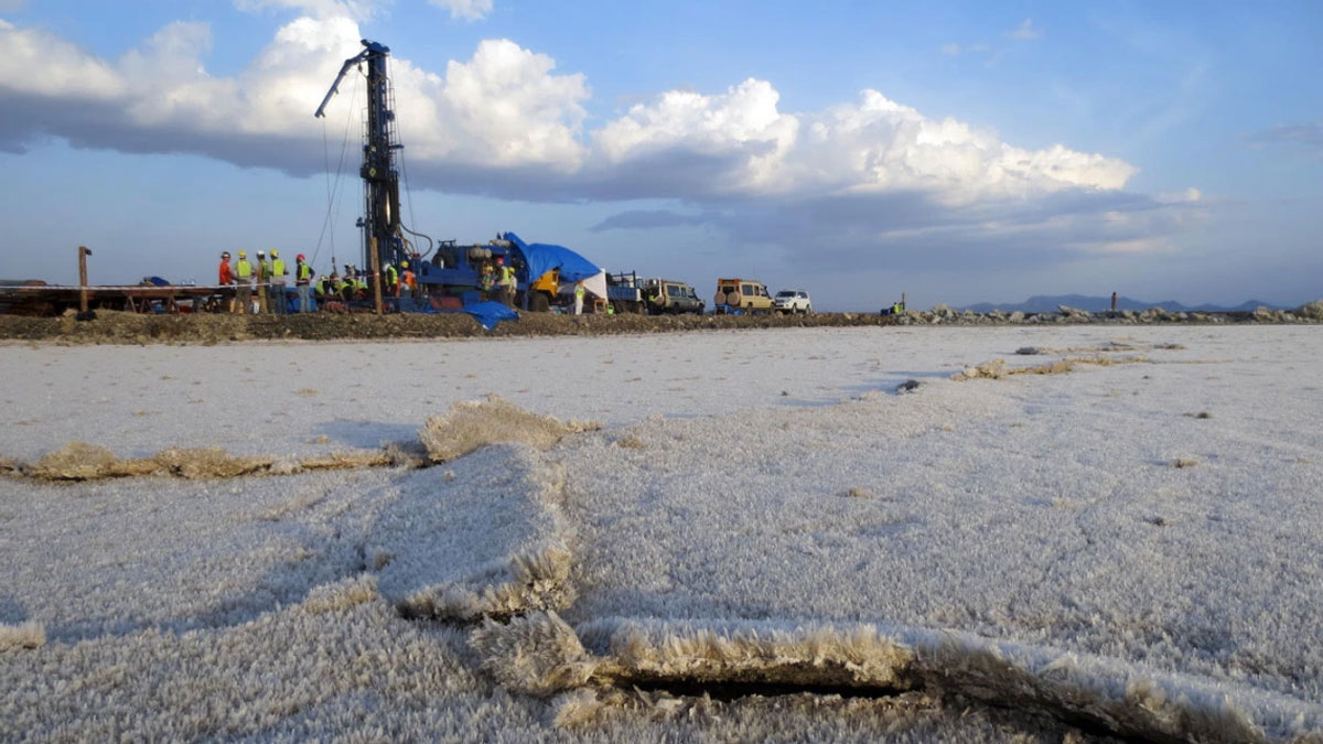
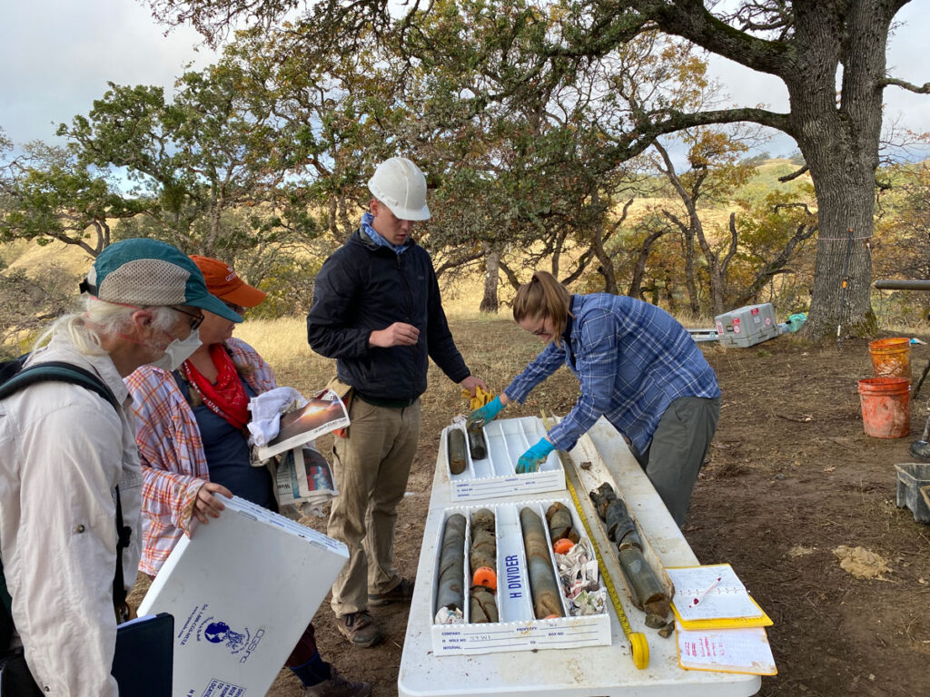
Scientific drilling is the primary means of systematically and rigorously investigating the constituents and processes of Earth’s deep continental subsurface.
We can learn much about our planet from space- and airborne sensors, instruments set on the surface, and studies of formerly buried but now exposed rocks and other materials. But to understand what Earth is really like on the inside, there’s often no substitute for digging—or drilling—below the surface.
Whether to uncover information about volcanic and tectonic hazards, past climatic conditions, or energy sources old and new, scientific drilling is the primary means of systematically and rigorously investigating the constituents and processes of Earth’s deep continental subsurface. That has been the case for most of the past half century. And with current facilities serving scientists across many geoscience disciplines, continental scientific drilling (CSD) is poised to continue revealing insights and answers to questions that affect us all.
Early Projects Set the Stage
Most world-class scientific drilling projects today are international efforts, but seminal U.S.-led CSD initiatives starting nearly 50 years ago set the stage for more recent, ongoing, and planned campaigns and laid the groundwork for many future discoveries.
Planning for the major Hawaii Scientific Drilling Project (HSDP), for example, began in the 1980s, and the initial drilling of long cores, intended to illuminate the origins of intraplate volcanoes, occurred in the 1990s. Several subsequent drilling projects at active Hawaiian volcanoes emerged from HSDP and continue to probe the suitability of coastal volcanic systems as disposal sites for supercritical carbon dioxide (CO2) and the geothermal characteristics of coastal volcanic terranes.
Also beginning in the 1980s, the Newark Basin Coring Project produced a record of global climate cycles dating back 200–230 million years, preserved in lake sediments cored from the Newark rift basin of New York, New Jersey, and Pennsylvania. The project revealed groundbreaking records of “hothouse” era climate variability, showing that astronomically driven environmental variability has long been at work on continents. It also foreshadowed drilling efforts in active continental rift basins, such as in East Africa (e.g., the Lake Malawi Scientific Drilling Project, the Hominin Sites and Paleolakes Drilling Project), and other ongoing deep-time initiatives investigating ancient greenhouse-icehouse climate transitions.
In 1979, drilling at Dry Lake Valley near the San Andreas Fault in California demonstrated the importance of sampling fault zone material from the subsurface. Collected samples showed the presence of minerals that could significantly control fault mechanical and hydrological behavior.
Measurements and samples obtained from the San Andreas Fault Observatory at Depth borehole documented the critical role fluids play in fault zone strength and slip styles.
That work led to the creation of the San Andreas Fault Observatory at Depth (SAFOD) project. SAFOD, one of the most ambitious drilling projects to date, demonstrated the feasibility of drilling, sampling, and instrumenting faults at earthquake depths. Research facilitated by SAFOD has revolutionized our understanding of earthquakes and faulting on strike-slip plate boundaries. For example, measurements and samples obtained from the SAFOD borehole documented the critical role fluids play in fault zone strength and slip styles and showed that small earthquakes can exhibit the same behaviors as large earthquakes.
The successes of these efforts and others internationally, such as the German Continental Deep Drilling Program, led to the founding of the International Continental Scientific Drilling Program (ICDP) in 1996, which ushered in a broad array of advanced drilling efforts.
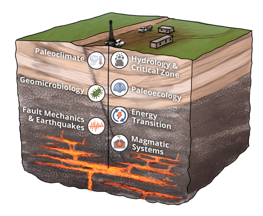
A Wide Spectrum for Scientific Drilling
Today, projects supported by ICDP, the National Science Foundation’s (NSF) CSD Facility, and numerous other groups worldwide cover a wide spectrum of investigations. Data collected from these projects provide context and understanding of Earth’s geologic, climatic, and biotic past and present-day processes, conditions, and resources below the surface.
Drilling of the continents to study changes in climate over geological timescales complements ocean and polar drilling efforts while also addressing unique aspects of global climate and shedding light on acute societal challenges. For instance, drilling sediments in the high Andean catchment of Peru’s Lake Junin recovered a 700,000-year record of low-latitude tropical alpine glaciations in a region where such information has been scant. This record shows clear parallels with and teleconnections to high-latitude and global ice volume fluctuations [Rodbell et al., 2022]. It also provides a long-term view of hydrologic boundary conditions that offer context for rapidly diminishing tropical glaciers, which are threatening water security and cultural traditions among Andean communities.
Drilling into the Samail Ophiolite through the Oman Drilling Project is producing remarkable discoveries from some of the best-preserved specimens of ocean crust and mantle exposed on land. The long, continuous rock sequence collected—which includes telltale marine crustal components such as the dike-gabbro and crust-mantle transitions—is largely unattainable via traditional in situ ocean drilling because of the technical challenges of accessing hot crust and mantle.
Using the project’s borehole observatory, scientists have been examining active alteration of peridotite ocean crust and mantle, gathering baseline information on subsurface microbial processes, and gaining insights into hydrogen formation through serpentinization of oceanic rock [Kelemen et al., 2021]. Key project results have documented, for example, reactive fluid transport processes that facilitate CO2 removal from the atmosphere and have shown that the ophiolite complex continuously generates hydrogen that is subsequently consumed by microbes.
Continental scientific drilling (CSD) efforts are also pushing the envelope of geothermal energy exploration and generation.
CSD efforts are also pushing the envelope of geothermal energy exploration and generation. The Cornell University Borehole Observatory is using a 3-kilometer-deep borehole on its campus in Ithaca, N.Y., to assess the potential for geothermal energy extraction and implementation of an enhanced geothermal system (EGS) in a region with only moderate subsurface heat flow and modest traditional geothermal resources. The project fosters technologies for the use of direct geothermal heating and enhanced geothermal heating in cold climates, and it is serving as a test bed for studying the mechanical responses of rocks in a region of low natural seismicity.
Meanwhile, at the University of Utah’s FORGE (Frontier Observatory for Research in Geothermal Energy) laboratory, a research facility set in the Basin and Range Province of the U.S. West, multiple boreholes and observatories are being used to test new technologies for EGS and to determine optimal subsurface conditions for stimulating artificial fractures in hot, dry rock environments.
At the interface of the solid Earth and the atmosphere, scientific drilling into the critical zone—the life-sustaining layers of soil, weathered bedrock, water, and biota—is helping with the challenging task of quantifying influences on the zone’s subsurface structure [Donaldson et al., 2026]. The Bedrock Critical Zone Network, for example, is pairing drilling with geophysical surveys to evaluate how the underlying bedrock controls chemical and physical weathering as well as geomorphic, hydrologic, and ecological processes. This critical zone work has illuminated connections between tectonic stresses, bedrock fracturing, and the initiation of chemical weathering [Holbrook et al., 2019], and it has revealed the role of volumetric strain produced by physical weathering in generating bedrock porosity [Riebe et al., 2021].
Many other important CSD projects have been completed recently or are underway or on the horizon. The Trans-Amazon Drilling Project finished a major drilling campaign in September 2024, seeking to deliver geological records of Cenozoic atmospheric and ecosystem changes across the entire Amazonian catchment [Baker et al., 2015].
Also, the second phase of the Colorado Plateau Coring Project is unearthing details of major biotic and Earth system transitions during the Mesozoic from Arizona and Utah. Project researchers are assessing paleoclimate trends—the Mesozoic climate is hypothesized to have shifted from a megamonsoon-dominated system toward dryer conditions—driven by the gradual northward movement (i.e., paleolatitudinal drift) of the ancient North American plate [Olsen et al., 2018].
The upcoming Lake Izabal Basin drilling project in Guatemala will study plate boundary tectonics and earthquake history, the volcanism of the Central American Volcanic Arc, and regional climate over the past 12 million years.
On a broader scale, the Geological Research through Integrated Neoproterozoic Drilling (GRIND) project is acquiring a global archive of cores dating to between 1 billion and 520 million years ago. The records acquired will assess one of Earth’s most transformative intervals—when rising atmospheric oxygen levels facilitated the evolution of increasingly complex multicellular life—in parallel with strong shifts in the carbon cycle and major global glaciations. Already, the GRIND project has produced critical insights on the Ediacaran-Cambrian transition.
New Technologies Drive Advances
Technologies new—or newly adapted—to CSD are transforming our understanding of the deep subsurface.
Early CSD projects relied on relatively rudimentary drilling technology and analyses of cored material and, as a result, faced challenges related to the quality of recovered cores, the depths attainable, and the detail with which cores could be studied. But technologies new—or newly adapted—to CSD are transforming our understanding of the deep subsurface.
Several recent CSD projects have leveraged wireline diamond coring systems with triple-tube core barrels and rigid plastic core liners. These systems dramatically improve the quality and analytical potential of recovered cores in consolidated or lithified sedimentary formations, particularly those with fractured or friable textures [e.g., Olsen et al., 2018]. This approach also enables improved core scanning, inspection, and handling procedures, allowing for better comparisons with data from scientific ocean drilling and lake drilling campaigns.
Recent developments in coring techniques that use percussion and vibration to drive core tubes into the ground have filled gaps in available drilling infrastructure, enabling drilling in modern sedimentary basins to reach depths previously attainable only using more expensive heavy drilling equipment. These techniques have yielded exceptionally long core samples and resulting paleoenvironmental records at low cost [e.g., Lenz et al., 2022].
Other enhancements in coring tools for deeper wells continue to improve drilling outcomes and core recovery and collection. Long-format coring systems that include jam mitigation systems and are deployed on conventional well drilling rigs can collect core runs up to 10 times longer than those of traditional conventional core runs, significantly reducing costs of coring in deep or high-pressure environments. Directional drilling, in which drillers can steer the drill bit, offers promise for reaching subsurface targets not accessible by vertical wells because of challenging surface or subsurface conditions. And improvements in drill bit design, combined with sensor data leveraged to mitigate drilling problems, have yielded reductions in drilling time and cost for deep wells.
Developments in cleaner drilling and sample handling protocols and in using fluid tracers have enabled routine collection of geomicrobiological samples that have transformed our understanding of the deep biosphere [e.g., Suzuki et al., 2024]. In addition, researchers are using state-of-the-art scanning and sensing approaches such as hyperspectral imaging, X-ray computed tomography scanning, and laser-induced breakdown spectroscopy to study cored materials and drilled boreholes in greater detail.
CSD is producing vast amounts of new digitized data, opening opportunities for researchers to apply machine learning and other advanced data analysis methods in core studies.
By deploying fiber-optic cables and instrumentation for distributed sensing—which detects changes in subsurface vibrations, seismicity, strain, and temperature—scientists are accelerating the characterization of underground forces, structure, and thermal conditions at higher accuracy and resolution [Li et al., 2024]. Boreholes instrumented with fiber-optic cables are enabling studies of, for example, motion along faults, geothermal reservoirs, and subsurface conditions relevant to enhanced geothermal systems.
With the proliferation of projects and approaches, CSD is producing vast amounts of new digitized data, opening opportunities for researchers to apply machine learning and other advanced data analysis methods in core studies. These approaches have shown potential for characterizing core mineralogy and optimizing drilling parameters to reduce costs.
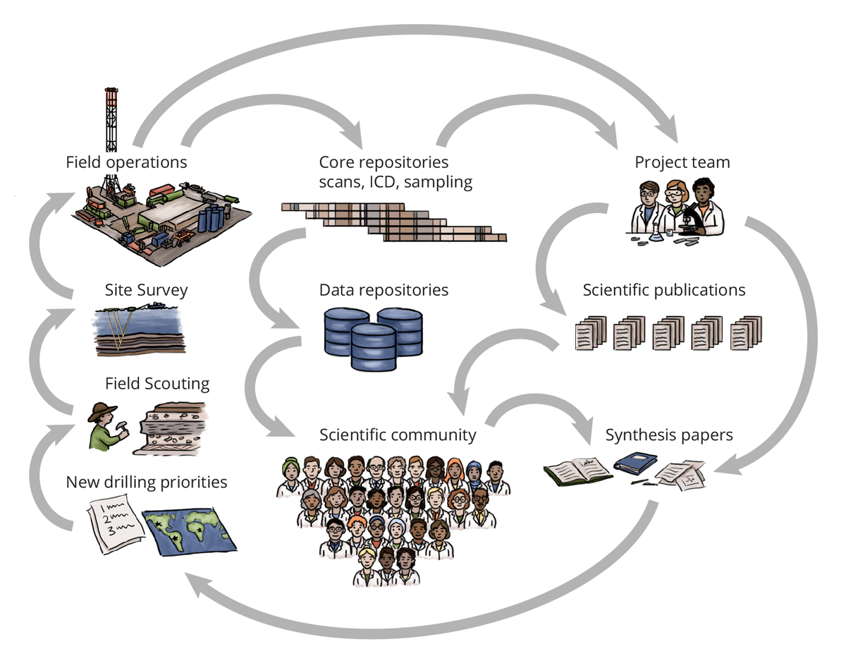
The Continuing Need for CSD
The continental subsurface is considerably understudied compared with the ocean floor, which has been cored consistently and extensively across hundreds of expeditions through programs such as the International Ocean Discovery Program and its predecessors. Fewer continental sites have been drilled largely because of the intermittent funding frameworks available for CSD, as well as the bespoke objectives and technical and logistical needs of individual CSD projects, which drill from unique surface environments into different types and thicknesses of sediments and rocks.
Considering how little of the continental subsurface we’ve seen so far and the importance of surveying it, scientists are keenly interested in guiding current and future CSD efforts to ensure they provide scientifically and societally meaningful results. In October 2024, scientists gathered at a workshop hosted by NSF’s CSD Facility to articulate community priorities, integrate the vision between research domains, and develop long-term plans for CSD initiatives. Among the priorities discussed were ways in which continental drilling can support research and insights into emerging energy sources, natural hazards, paleoclimates, and the deep biosphere.
As part of societal transitions to emissions-reducing energy sources and technologies, vital advances are needed to improve capabilities for extracting and storing geothermal energy and hydrogen and for sequestering and mineralizing CO2 deep underground. These transitions will also require significant amounts of critical minerals needed for enhanced electrification and energy storage, such as lithium, nickel, copper, cobalt, and rare earth elements. CSD is key for advancing these scientific frontiers. It could help researchers develop and optimize methods to extract geothermal energy and stimulate the production of geologic hydrogen, and it could help scientists understand the fluid-rock-microbe interactions that lead to rare earth element mineralization.
Subsurface investigations of magmatic complexes using scientific drilling could help researchers assess volcanic eruptive histories and factors indicative of eruptive behaviors.
Scientific drilling and borehole observations are also needed to better characterize natural hazards. In particular, this work could help scientists to determine the parameters of and controls on earthquake initiation, propagation, and arrest that are still uncertain, partly because of the challenges of accessing and instrumenting faults [Cochran et al., 2025]. Improving our understanding of these controls, including on the triggering of natural earthquakes and anthropogenically induced seismicity related to energy development and carbon sequestration, would benefit communities globally by helping them prepare for and mitigate risks from seismic hazards.
Subsurface investigations of magmatic complexes using scientific drilling could help researchers assess volcanic eruptive histories and factors indicative of eruptive behaviors such as seismicity, heat flow, and fluid flow. They could also reveal coupling between magmatic and adjacent hydrothermal systems, as well as the relationships of geothermal and hydrothermal systems to ore deposits, providing valuable information for energy and mineral exploration.
Long-term records of past Earth and atmospheric processes, and of the living systems that depend on them, have been determined mainly from ocean drill cores that typically have been collected far from sites where humans evolved and now live and that span only about 5% of Earth’s history. Drilling continental rocks, including sedimentary archives, which represent about 85% of the planet’s history, allows reconstruction of a fuller range of past conditions. It also enables analyses of Earth system responses on land during periods of prolonged warm temperatures and elevated atmospheric CO2, which may serve as analogues for studying the potential effects of future warming.
Additional high-fidelity, long-duration, and high-resolution climate records are required to constrain past conditions—and the range of possible future conditions—more precisely [Obrist-Farner et al., 2024]. Ancient deposits from long-lived lake beds, such as at Lake Tanganyika in Africa, are well suited to provide these records. These sites also offer opportunities to quantify patterns of past ecoevolutionary dynamics (i.e., how ecology and evolution influence each other) [Spanbauer et al., 2026] and to determine the rates and drivers of speciation and extinction at locations where scientists can evaluate hypotheses relating environmental history to hominin evolution [Obrist-Farner et al., 2024].
How such dynamics play out meters to kilometers underground in the deep biosphere is among the most exciting and important frontiers for future discovery through CSD. Exploring the diversity and adaptations of subsurface microbes and examining their interactions with fluids, rocks, and biogeochemical feedbacks not only expand our knowledge of life and the conditions under which it can survive but also improve our understanding of elemental cycling and mineralogical distributions.
Challenges and Opportunities
For all its past achievements and future promise, CSD efforts continue to face unique challenges, driven in part by infrastructure needs that must be tailored to individual projects. Funding available for CSD is particularly limited, which constrains the scope of inquiry for drilling projects and requires project teams to stitch together funds through numerous proposals to science funding agencies and prospective industry partners distributed globally.
Unlike other infrastructure-intensive, discovery-focused science initiatives, project implementation is heavily dependent on participating scientists—rather than professional support staff—coordinating aspects of permitting, logistics, and contracting in addition to fulfilling their scientific roles. This work creates enormous administrative burdens on the science teams, limits participation, and increases project lead times, which routinely extend 6 to 8 years or more from inception to implementation.
Other challenges arise from needed technological developments (e.g., to drill into superhot rocks containing corrosive and sometimes supercritical fluids) and the lack of required infrastructure (e.g., to implement lake drilling projects that are otherwise approved and shovel-ready).
Despite such challenges, future CSD efforts aim to provide opportunities for research and innovation across the spectrum of continental geoscience, as well as for cross-disciplinary integration among fields. Specific priority developments for the CSD community include a fully instrumented earthquake field experiment; a magma observatory for testing ultrahigh-temperature drilling technology; coring transects that span key gradients in latitude, altitude, climate, continental margins, and stratigraphic time; containerized clean labs and modular platforms to enable deep-biosphere and lake drilling operations; flexible methods for iterative sampling and characterization of heterogeneous critical zone conditions at limited-access locations; improved mechanisms for industry partnerships; and coordination between U.S. and state agencies engaged in CSD to improve the visibility of science priorities, funding opportunities, and project outcomes (samples, data, publications, etc.).
Achieving these goals will demonstrate the value of past projects and support the new science we need to continue advancing our knowledge of Earth’s continents and the hazards, resources, and insights they hold.
Acknowledgments
This article was partially motivated by discussions at the October 2024 meeting held in Alexandria, Va., and hosted by staff of NSF’s CSD Facility. This facility assists with the financial, logistical, and technical planning and execution of U.S.-led CSD projects, as well as initial core analyses and repository curation of cores and data. Communities representing specific scientific domains developed white papers in advance of the meeting and are now publishing individual articles describing their community vision in disciplinary journals.
References
Baker, P. A., et al. (2015), Trans-Amazon Drilling Project (TADP): Origins and evolution of the forests, climate, and hydrology of the South American tropics, Sci. Drill., 20, 41–49, https://doi.org/10.5194/sd-20-41-2015.
Cochran, E. S., et al. (2025), Potential for continental scientific drilling to inform fault mechanics and earthquake science, Seismica, 4(2), https://doi.org/10.26443/seismica.v4i2.1700.
Donaldson, A., et al. (2026), Drilling within the critical zone, Hydrol. Processes, 40(3), e70463, https://doi.org/10.1002/hyp.70463.
Holbrook, W. S., et al. (2019), Links between physical and chemical weathering inferred from a 65-m-deep borehole through Earth’s critical zone, Sci. Rep., 9, 4495, https://doi.org/10.1038/s41598-019-40819-9.
Kelemen, P. B., et al. (2021), Initial results from the Oman Drilling Project Multi-Borehole Observatory: Petrogenesis and ongoing alteration of mantle peridotite in the weathering horizon, J. Geophys. Res. Solid Earth, 126, e2021JB022729, https://doi.org/10.1029/2021JB022729.
Lenz, M. M., et al. (2022), Climate, glacial and vegetation history of the polar Ural Mountains since c. 27 cal ka bp, inferred from a 54 m long sediment core from Lake Bolshoye Shchuchye, J. Quaternary Sci., 37, 818–835, https://doi.org/10.1002/jqs.3400.
Li, Y., R. Mellors, and G. Zhan (Eds.) (2024), Distributed Acoustic Sensing in Borehole Geophysics, John Wiley, Hoboken, N.J., https://doi.org/10.1002/9781394179275.
Obrist-Farner, J., et al. (2024), The palaeoclimate potential of continental scientific drilling, Nat. Geosci., 17, 1,187–1,188, https://doi.org/10.1038/s41561-024-01603-1.
Olsen, P., et al. (2018), Colorado Plateau Coring Project, Phase I (CPCP-I): A continuously cored, globally exportable chronology of Triassic continental environmental change from western North America, Sci. Drill., 24, 15–40, https://doi.org/10.5194/sd-24-15-2018.
Riebe, C. S., et al. (2021), Anisovolumetric weathering in granitic saprolite controlled by climate and erosion rate, Geology, 49(5), 551–555, https://doi.org/10.1130/G48191.1.
Rodbell, D. T., et al. (2022), 700,000 years of tropical Andean glaciation, Nature, 607, 301–306, https://doi.org/10.1038/s41586-022-04873-0.
Spanbauer, T. L., et al. (2026), Advancing ecology and evolution through continental scientific drilling, Trends Ecol. Evol., 41(2), P120–129, https://doi.org/10.1016/j.tree.2025.11.003.
Suzuki, Y., et al. (2024), Subsurface microbial colonization at mineral-filled veins in 2-billion-year-old mafic rock from the Bushveld Igneous Complex, South Africa, Microb. Ecol., 87, 116, https://doi.org/10.1007/s00248-024-02434-8.
Author Information
Christopher A. Scholz ([email protected]), Syracuse University, New York; Anders Noren, University of Minnesota–Twin Cities, Minneapolis; Lisa Park Boush, University of Connecticut, Mansfield; Brett M. Carpenter, University of Oklahoma, Norman; and Russell Callahan, University of Connecticut, Mansfield