
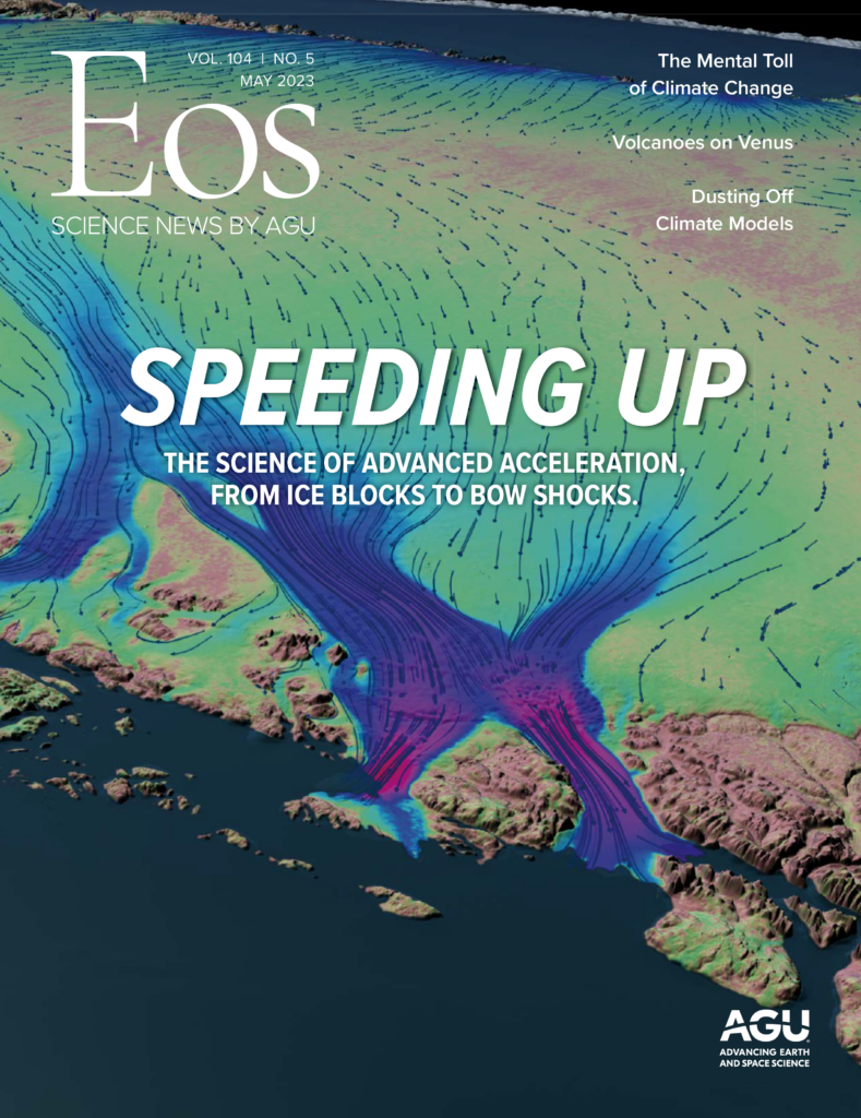
When something is dragging along at an annoyingly slow rate, we often describe the pace as “glacial.” Headlines have complained about the glacial pace of presidential appointments, college athletics reforms, and the early stages of the COVID-19 inoculation campaign. Online review sites carry snippy comments about glacially slow food deliveries and Internet service. In the movie The Devil Wears Prada, Meryl Streep’s character tells a subordinate, “By all means, move at a glacial pace. You know how that thrills me.” It was not a compliment.
It might be time to rethink that phrase. Glaciers and ice sheets are moving much faster now than they were just a couple of decades ago. The vast majority of them are retreating, thinning, cracking, or shrinking at unprecedented speeds.
Heated by Earth’s warming atmosphere and oceans, Greenland’s massive ice sheet is melting more rapidly and running into the sea. Weakened by changing currents in the Southern Ocean, the floating extensions of Antarctica’s even bigger ice sheet are cracking off like slivers of peanut brittle. And smaller mountain glaciers from Alaska to New Zealand are vanishing, setting up potentially major consequences for people and ecosystems that depend on their water.
“Every region that has glaciers is out of balance,” said Alex Gardner, a research scientist at NASA’s Jet Propulsion Laboratory. “None are in equilibrium with the climate. None are healthy. And the problem has been accelerating.”
“We’re data starved. We’ll use anything we can get our hands on.”
All of that is contributing to one more speedup: the rise in global sea level. “The most dominant reason we study the speed of ice is to understand the current and future contributions of ice to sea level rise,” said Richard Forster, a geologist and associate dean at the University of Utah.
“Ice velocity is a key parameter that provides critical information on the glacier response to climate change,” said Romain Millan, a glaciologist at the National Centre for Space Studies in Grenoble, France. “Ice velocity observations are essential to better model the physics of glaciers and their evolution in the future.”
And researchers have said there is still a lot of uncertainty in their measurements and conclusions. “We’re data starved,” said Helen Fricker, a professor at the Scripps Institution of Oceanography at the University of California, San Diego. “We’ll use anything we can get our hands on.”
Multiple Tools for Measuring the Ice
In the early days of tracking the speeds and directions of ice flows, observations made were entirely from the ground. “People would put a pole in the ground, come back later, see how far it had moved, then do it again,” explained Richard Alley, a professor of geosciences at Pennsylvania State University. “To get the ice thickness, they’d stop, dig a hole, put in an explosive, set it off, and listen to the sound waves. But that only gave you information for one small point, and it was hard work.”
Scientists still study ice from the surface, although today they use GPS to track motions and ground-penetrating radar to measure ice thickness and the contours of the bedrock. But they’re also gathering data from the ground, air, and, especially, space.
“Thanks to the range of satellite approaches we have at our disposal today, we can now determine the sea level change contribution due to the polar ice sheets with a factor of 10 improvement in precision—roughly to within 0.1 millimeter of sea level change per year,” said Andrew Shepherd, director of the Centre for Polar Observation and Modelling at the University of Leeds in the United Kingdom.
The approaches provide several major categories of observations.
Imagery is provided by the Landsat series of spacecraft, especially Landsat 8, which was launched in 2013 and passes over the same swath of Earth every 16 days, recording visible and infrared wavelengths with a resolution as high as 15 meters. “Landsat has produced some spectacular images, and it gives us a long historical perspective,” said Gardner, who is a member of several satellite mission teams. “It can observe how much the ice has receded, the change in area, and changes in flow.”
Altimetry comes from the Ice, Cloud, and land Elevation Satellite-2 (ICESat-2), which uses a laser to measure changes in elevation across all of Earth’s surface, with an emphasis on the ice sheets, where changes reveal how the ice is thinning. “For the glaciers in Greenland, altimetry shows that they can thin by as much as 10 to 20 meters a year,” said Eric Rignot, a professor of Earth system science at the University of California, Irvine. “In Antarctica, especially West Antarctica, the thinning is about 10 meters per year.”
The Gravity Recovery and Climate Experiment Follow-On (GRACE-FO mission), which was launched in 2018, measures changes in ice sheet mass. Twin spacecraft maintain a laser link to precisely measure the distance between themselves. As they pass across Earth’s surface, tiny changes in the gravitational pull from the mass of the material below cause the gap distance to change. Precise calculations reveal the mass of the surface features, with repeated observations revealing how the mass has changed over time.
“It’s so sensitive that when we had the heavy rains here in California, GRACE told us that California got heavier—its gravitational pull increased as a result of all that water,” said Gardner. “The greatest changes in gravity are in the ice sheets and glaciers because all of that mass is being lost.”
A Game Changer at the Surface

Perhaps the most powerful arrow in the satellite quiver is the synthetic aperture radar (SAR) deployed by the European Space Agency’s Sentinel program—“a real game changer,” according to Shepherd, and “the ultimate technology,” according to Rignot.
Sentinel satellites emit pulses of radio energy at wavelengths similar to those produced by microwave ovens, then measure the return signals from the ice. SAR can operate in the dark and penetrate the clouds, providing almost continuous coverage.
Researchers don’t need to see specific landmarks, such as crevasses, to measure ice velocities. Instead, they apply a technique that allows them to measure pixel-to-pixel variations in intensity.
Researchers don’t need to see specific landmarks, such as crevasses, to measure ice velocities. Instead, they apply a technique that allows them to measure pixel-to-pixel variations in intensity. They match surface patterns from image to image and track how the patterns have moved.
SAR also tracks phase shift, which describes the offset between two signals at different points of their cycles at a given time. “It’s orders of magnitude better at measuring glacial velocities—down to centimeter scales,” he said.
The next SAR-carrying mission is NISAR (NASA-ISRO Synthetic Aperture Radar), a joint project of NASA and the Indian Space Research Organisation, currently scheduled for launch in early 2024.
“NISAR is a whole ‘nother step up,” said Ian Joughin, leader of the mission’s cryosphere science team and a glaciologist at the University of Washington. It will operate at longer wavelengths, solving a problem created by certain changes in the surface.
In addition, NISAR’s radar will switch on for every pass over land, which isn’t the case for Sentinel. And whereas Sentinel and its predecessors have left big “donut holes” in observations near the South Pole, NISAR will provide more complete coverage of central portions of the continent. The combination of upgrades should allow the craft to accomplish in weeks what currently takes years, Joughin said.
Ice Sheets Go on a Diet
Even with all of these advanced satellite observations, though, the mysteries of ice velocities are far from solved. “We can’t detect the full extent of the speedup with current technologies,” said Rignot.
Still, he and other scientists have taken stabs at it. They have estimated the amount of ice lost from the Antarctic and Greenland ice sheets and smaller glaciers, calculated the rate at which ice loss has accelerated, and figured the amount of water those losses have contributed to rising sea level.
In a 2022 paper in Earth System Science Data, for example, the authors calculated that combined, the Greenland and Antarctic ice sheets lost 7,563 gigatons of water (± 10%) from 1992 to 2020, raising sea level by roughly 21 millimeters [Otosaka et al., 2022]. And the rate of mass loss rose from roughly 105 gigatons per year in the first 5 years of the study to 372 gigatons in the last 5 years—an increase of 280%. Greenland accounts for more than half of the total, even though Antarctica’s ice sheet is more than 8 times more massive. (Antarctica holds enough ice to add 58 meters to global sea level, whereas Greenland banks only 7 meters.) In all, the two ice sheets have accounted for about one third of sea level rise, with the remainder coming from expansion of the warmer water and melting of smaller alpine glaciers.
The bulk of mass loss on the Antarctic and Greenland ice sheets is driven by different processes, accounting for their different velocities: Whereas Antarctica is being chipped away along the edges, Greenland is melting.
Surface temperatures in Greenland have risen far more than the global average—roughly 5°C in winter and 2°C in summer. “Greenland is more temperate, so there’s much more significant melt than in Antarctica,” said Forster. “About half of its mass loss is coming from melting of ice versus discharge—icebergs breaking off. And the melting is increasing faster.”
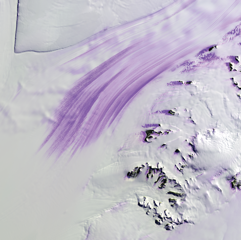
“The Greenland glaciers are retreating almost everywhere,” said Rignot. “There are very few that aren’t. They’re moving at up to half a kilometer per year. And it’s in all four corners.”
The study of satellite observations concluded that from 1992 to 2020, Greenland’s ice loss averaged about 277 gigatons per year.
The warmer climate melts enough ice in the summer to create lakes of up to a couple of kilometers across, Joughin said.
Some of the water escapes and flows all the way to the sea, but some of it tunnels through the ice and reaches bedrock. It then continues its downhill flow, serving as a lubricant for the ice above. “That changes the dynamics of the glacier,” Fricker said. “It helps the ice slide faster over the bedrock, and that’s increasing the ice flow rates.”
“We’re very interested in how glaciers slide,” said Gardner. “There’s a lot of progress in these sliding laws, especially over the last 5 years. We’re establishing the relationship between water pressure at the bed of the glacier and how the glacier slides.”

Researchers also need to understand the bedrock—its composition, slope, texture, and other characteristics—to accurately model how ice slides across it, with or without a lubricating layer of water. Airborne ground-penetrating radar provides some of that information. Missions are limited by weather, aircraft capabilities, and other constraints, so the models of solid rock below both the Greenland and Antarctic ice sheets remain incomplete.
Airborne missions also provide important looks at ocean conditions around ice sheets, which help scientists better understand how oceans contribute to ice loss and how the inflow of fresh water changes ocean temperatures, salinity, and circulation.
The combination of observations is helping scientists refine their models of how fast the ice moves, thins, and breaks away, improving forecasts of future mass loss and sea level rise.
Holy Bad Word, What Just Happened?
Three quarters of Antarctica is ringed by ice shelves—parts of the ice sheets, often hundreds of meters thick, that stretch out as floating extensions over the open ocean, fed by glaciers and ice streams that flow at anywhere from a few meters to a few kilometers per year. The ice shelves cover an area of more than 1.5 million square kilometers—as big as the entire Greenland Ice Sheet.
Most Antarctic ice shelves were stable for centuries. Over the past 2 or 3 decades, however, they’ve shown signs of weakening. They’re moving faster as they lose more ice to calving hastened by warmer ocean currents below.
Greater instability among ice shelves is changing the continent’s mass balance—the total mass determined by snowfall adding new ice to Antarctica, balanced by the loss of ice through calving and melting (the influence of melting is currently negligible in the still-cold continent). The total input has stayed about the same—roughly 2,000 cubic kilometers per year—but the output has increased significantly, chipping away at the total volume.
The problem is especially acute in West Antarctica, which faces the Pacific Ocean, and the Antarctic Peninsula, a tentacle-like spit that extends toward South America. Some ice shelves in these regions could collapse in the decades ahead, allowing glaciers behind them to push into the sea, adding to sea level rise.
Satellite observations show that glaciers in West Antarctica are advancing up to 100% faster today than they were in the 1980s, Rignot said, with some moving at up to 3 kilometers per year. A study led by Rignot reported “widespread glacier speedup that propagates 100 [kilometers] inland” to divides between major sections of the ice sheets [Rignot et al., 2022].
The same study that measured global ice loss indicated that the loss in West Antarctica increased from about 39 gigatons per year in 1992–1996 to 131 gigatons per year in 2012–2016, with a drop to 94 gigatons in 2017–2020 thanks to a couple of seasons of especially heavy snowfall [Otosaka et al., 2022]. In addition, altimetry showed that the thickness of the ice in West Antarctica is decreasing by as much as 10 meters per year, Rignot said. Changes in the region accounted for roughly 30% of all Antarctic ice loss.
Changes in wind patterns are pushing warmer water toward the coast of West Antarctica, weakening ice shelves, especially where they intersect land at a glacier’s grounding line. The grounding lines of some shelves and glaciers are hundreds or thousands of meters below sea level, Rignot and other scientists explained, because the bedrock in some parts of West Antarctica forms a giant bowl that rests below sea level. If the ice shelf breaks off at the grounding line, the ice behind it can simply slide into the sea.
“It’s a matter of bottlenecks,” said Alley. “Almost all of the shelves are held back by friction with the sides, or by islands, or by local high spots on the seafloor. Because of that, they’re holding back the ice behind them. But if they weaken or go away, the grounded part can spread out and start floating, and that raises sea level.”
“Most of the time,” Alley said, “in most places, because the glaciers are wedged in by bottlenecks, changes tend to be moderate to slow. You see something that’s kinda sorta behaving itself. It sits there, sits there, sits there, doing little things, then suddenly, ‘Holy bad word—what just happened?’”
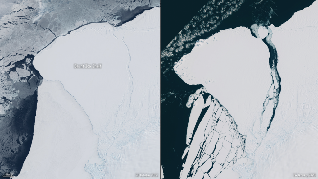
Perhaps the best-known example of this phenomenon was the 2002 collapse of the Larsen B ice shelf. It disintegrated in a matter of weeks, sending roughly 3,250 square kilometers of ice skittering into the ocean.
“That was a real wake-up moment for the whole community,” said Fricker. Landsat 7 observations indicated that the flow rates of adjoining glaciers into the gap increased by factors of 2–6 over the following few months, whereas ICESat data showed a drop of 38 meters in the elevation of one large glacier. (Larsen B was the most dramatic of several Larsen ice shelf losses. Larsen A broke off in 1995, and part of Larsen C followed in 2017. In all, Larsen has lost a quarter of its surface area.)
Scientists are concerned that the Larsen B scenario could also play out in West Antarctica with the Thwaites and Pine Island ice shelves as well as with a few smaller glaciers. All have their grounding lines deep below the surface, so if they perish, the bottlenecks holding back upstream ice would vanish.
Thwaites, in fact, has been dubbed “the Doomsday glacier,” although Joughin said the moniker is both misleading and unfortunate. “It’s likely to break up, potentially in the next decade, but…the ice won’t just come spilling out. It’s not like the ice shelf breaks and Florida suddenly floods,” he said.
Understanding the possible flow rates of Thwaites and other glaciers is complicated by uncertainties in the ice sliding law, the thickness of the ice, and the contours of the bedrock.
“We’ve made great advances in our modeling over the last 20 years, maybe less,” said Gardner. “They’re quite complex models, and the sophistication required to run them is quite high. Now, we’re focusing on the edge conditions—the remaining unknowns.”
Drying Up the Rivers
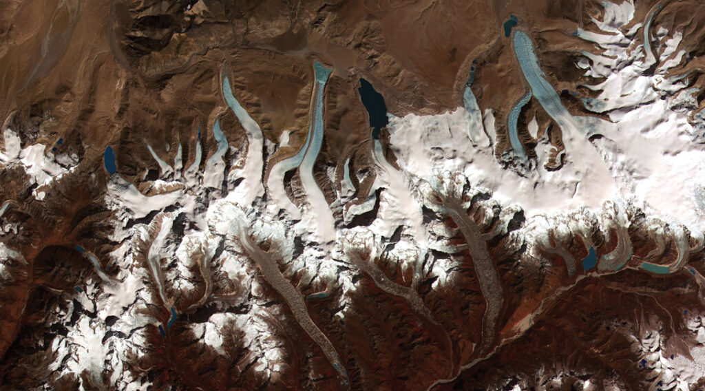
The rest of the world’s glaciers are in trouble as well. Although they are little more than ice chips compared with the Greenland and Antarctic ice sheets, glaciers supply fresh water to roughly 2 billion people, so their disappearance would create hardships for surrounding populations and ecosystems.
“The rest of the world is a big player now” in ice losses and contributions to global sea level rise, said Gardner.
A study of 98% of the world’s glacier area, led by Millan and published last year in Nature Geoscience, found that many major systems are retreating at alarming rates [Millan et al., 2022].
The study compared hundreds of thousands of pairs of images snapped by Landsat and Sentinel satellites at intervals of up to 400 days to plot changes in glacial coverage.
Glaciers in west Asia’s Karakoram Mountains, for instance, retreated at roughly 2.3 kilometers per year over the study period, and Penguin Glacier in southern Patagonia retreated by 12 kilometers per year. The ice volume in three regions of the Andes Mountains, which provide water to some 4 million people in South America, was 20% less than reported in previous studies. And in the Upper Indus and Chenab basins, in the mountains of central Asia, glaciers lost about a tenth of a meter per year in equivalent meltwater—a potential problem for the 8 million inhabitants who depend on it.
Another study, led by David Rounce of Carnegie Mellon University and published in January in Science, projected that 26%–41% of the total volume of ice contained in glaciers outside the major ice sheets could vanish by 2100 if the atmosphere were to warm by 1.5°C–4°C, adding 90–154 millimeters to global sea level [Rounce et al., 2023].
“Smaller [glaciers] are vanishing, and a significant number will be gone by the end of the century,” Gardner said. “Unlike the ice sheets, those glaciers act as reservoirs or batteries for hydrologic systems. They store water during the cold, rainy months and release it during the dry, warm months. The implication is that the water flow will be reduced when it’s most critical.”
In addition, several large hydroelectric plants are planned for the high mountains of Asia. With reduced streamflow, the plants would provide less electricity and might even have to be scrapped.
Even the glaciers in the Rocky Mountains are feeling the effects. “They’re very few and very small compared to other areas, but they’re all retreating quite dramatically,” said Forster. Glacier National Park in Montana, for example, draws tourists who expect to see…glaciers. As the park’s nominal features retreat, however, there’s less ice to serve as backgrounds for selfies.
And in the Wind River Range of Wyoming, the ecosystem depends on summer meltwater from the namesake glacier. As Wind River Glacier gets smaller and streamflow decreases, “it will disrupt the entire ecosystem,” Forster noted.
Eventually, the contribution to global sea level from these smaller systems will taper off, leaving only the great ice sheets of Greenland and Antarctica to worry about. Scientists will continue to monitor the speed at which their ice melts, slides, breaks, and recedes.
We may see more glacial speed records in the decades ahead, although the magnitude of the jump from present speeds remains uncertain. “Ice retreat is already pretty fast, but if we can get a better handle on the climate, we can slow it down,” said Rignot. “While retreat is inevitable, the speed can be controlled. That’s the important point.”
References
Millan, R., et al. (2022), Ice velocity and thickness of the worldís glaciers, Nat. Geosci., 15, 124–129, https://doi.org/10.1038/s41561-021-00885-z.
Otosaka, I. N., et al. (2022), Mass balance of the Greenland and Antarctic ice sheets from 1992 to 2020, Earth Syst. Sci. Data Discuss., https://doi.org/10.5194/essd-2022-261.
Rignot, E. (2022), Changes in Antarctic Ice Sheet motion derived from satellite radar interferometry between 1995 and 2022, Geophys. Res. Lett., 49(23), e2022GL100141, https://doi.org/10.1029/2022GL100141.
Rounce, D. R., et al. (2023), Global glacier change in the 21st century: Every increase in temperature matters, Science, 379(662), 78–83, https://doi.org/10.1126/science.abo1324.
Author Information
Damond Benningfield, Science Writer