
Mount Kinabalu is not the only puzzling geological landform in Sabah. Travel across the Crocker Range to the southeast of the state, and you will encounter circular basins that rise up from the surrounding landscape. The most spectacular of these is the Maliau Basin (Figure 1), which is around 30 kilometers in diameter and is encircled by an imposing ridge up to 1,500 meters high. The basin’s shape, clearly visible in satellite imagery and digital elevation maps, may at first suggest an impact crater, but closer inspection reveals that the interior contains a thick sequence of river delta sediments that were deposited at sea level 10–15 million years ago. What caused the uplift of southeast Sabah and the preceding 10 million years of subsidence, and how were these unusual basins formed?
The answers to these questions may be found in the postsubduction setting of northern Borneo. As recently as 5 million years ago, subduction stopped along the eastern margin of Sabah for reasons we do not fully understand. The mantle processes and changes in the regional stress field associated with such an event likely conspired with surface processes to help shape the landforms we observe today. Clearly, we require detailed images of the crust and underlying mantle to understand why subduction ceased and how the landforms of Sabah may be related to deeper processes in the mantle.
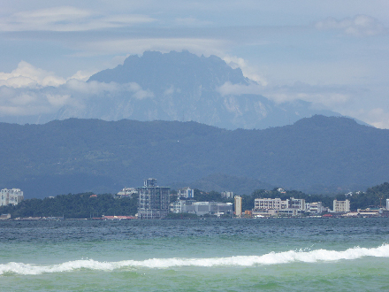
This is where the North Borneo Orogeny Seismic Survey (nBOSS) project, which involves Borneo’s first temporary seismic network, comes into play. The nBOSS project is the result of a collaboration between the University of Cambridge, University of Aberdeen, Universiti Malaysia Sabah, and the Malaysian Meteorology Department. In March 2018, we deployed a network of 46 broadband seismic stations, spaced about 45 kilometers apart, throughout Sabah (Figure 1). This dense cluster of stations complements the more widely spaced stations in Malaysia’s regional seismic network.
Sabah’s Complex Tectonic History
Sabah lies near the northeastern edge of present-day Sundaland, the continental core of Southeast Asia, and is separated from the Philippines by the Sulu and Celebes Seas. Like much of Borneo, it formed by accretion of continental and oceanic material onto the eastern margin of Sundaland during the Late Cretaceous to early Miocene times (~70–20 million years ago).
Sabah is an ideal location to study the process of subduction termination, which is one of the more poorly understood stages of the global subduction cycle.
During the Paleogene (which spans from ~60 to 25 million years ago), the proto–South China Sea was subducted beneath what is now the northwest continental margin of Sabah. This subduction process came to an end ~20 million years ago with the collision of two continents that resulted in the formation of the Crocker Range. Subsequently, there was a separate system of northward subduction of the Celebes Sea beneath eastern Sabah, which ended 5–6 million years ago.
The lithosphere that is now northern Borneo thus bears the signature of a southeast directed subduction system, followed by a northwest directed subduction system. Consequently, Sabah is an ideal location to study the process of subduction termination, which is one of the more poorly understood stages of the global subduction cycle.
Borneo’s First Dense Seismic Network
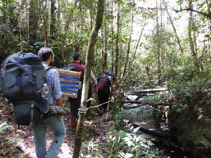
The nBOSS network, the first of its kind in Borneo, is supplemented by 24 permanent broadband seismic stations that form part of the Malaysian National Seismic Network. To install the instruments in our network, we used four-wheel drive vehicles to make use of all possible roads and fast motor boats to reach islands in the South China Sea. We dodged leeches as we trekked into the interior of the Maliau Basin and scaled Mount Kinabalu to install an instrument high on the mountain. The first batch of data was successfully recovered in September 2018, and now the data analysis has begun.
The network will be recording for a period of nearly 2 years. This time frame will allow us to record a sufficient number of distant earthquakes (Figure 2) for the application of a variety of seismic imaging techniques, including teleseismic tomography and receiver function and shear wave splitting analyses. We will extract further surface wave information from continuous ambient noise signals. The velocity and anisotropy models from this work will provide a number of critical constraints, including crustal thickness, mantle flow patterns, locations of lithospheric-scale faults, and discontinuities, that will feed into subsequent geodynamic modeling.

What Happens When Subduction Stops?
Recent tectonic activity in Sabah, such as the rapid uplift and exhumation of Mount Kinabalu [Cottam et al., 2013], may be related to subduction termination. However, the extent to which postsubduction processes have dictated the evolution of the surface geology in the past 5–6 million years and whether those processes continue to do so now are unknown.
Several models have been proposed for the crustal evolution of the region. One such model posits that localized uplift and detachment faulting have caused gravitational collapse—mountain ranges collapsing under their own weight—in the Crocker Range, resulting in the formation of the fold-and-thrust belt offshore of northwest Sabah [Hall, 2013]. Confirming that gravitational collapse is happening requires obtaining constraints on the geographic distribution and rates of uplift and linking these to mantle structure and processes.
Although several models all have merit, the picture is incomplete without some understanding of how they couple with mantle processes.
Another model says that continental extension has caused orogen collapse and produced a core complex [e.g., Lister and Davis, 1989] with the associated granite intrusion manifested by Mount Kinabalu. This model would explain both offshore subsidence and onshore uplift.
A third model says that a regional compressive stress field has localized strain in a foreland fold-and-thrust belt. This model can also explain onshore mountain building and does not require ongoing subduction or underthrusting.
The lack of constraints on mantle structure and dynamics beneath Sabah means that published models tend to focus on the crust, and even then, middle to lower crustal structure and processes are often largely based on speculation. Although the aforementioned models all have merit, the picture is incomplete without some understanding of how they couple with mantle processes.
On the basis of the presence of recent (~5 million years old) basalts with ocean island character in southeast Sabah, Hall [2013] proposed three models to explain the underlying cause for deformation of the lithosphere and vertical movements of the surface:
- detachment of the descending slab from the rest of the plate (slab break off)
- delamination and sinking of the dense root of the lithosphere into the mantle below
- gravitational instability due to a lithospheric drip (a sinking plume of cold, dense lithospheric material)
For instance, uplift and extension caused by slab break off could induce or enhance orogen collapse. Alternatively, if regional compression has localized strain, then there is no requirement for any significant mantle anomaly. Clearly, to properly understand the link between mantle and crustal processes, a multidisciplinary and multiscale approach is essential.
Linking Field Data and Models
The crust and upper mantle beneath Sabah have yet to be targeted by geophysical imaging studies. The only evidence to date comes in the form of global seismic tomography, which shows a distinct high-velocity anomaly in the upper mantle beneath northern Borneo [Hall and Spakman, 2015]. Although this evidence is potentially consistent with a remnant slab or mantle drip, the lack of resolution (>250 kilometers) precludes any further analysis.
The new tomographic and geodynamic models will provide valuable insight into how continents evolve.
Through the nBOSS project, we will use a multidisciplinary approach to address four specific aims: to understand mantle dynamics in a postsubduction setting; to determine the existence, cause, and extent of orogen collapse; to develop a model for postsubduction evolution of the continental crust-mantle system; and to unravel the cause of subduction termination in northern Borneo.
The new tomographic and geodynamic models will provide valuable insight into how continents evolve. The models we construct for the Sabah region can be compared with other recent postsubduction continental environments, including Europe’s east Carpathian-Pannonian region, North America’s Baja California, the Betic-Rif orogen in the western Mediterranean, and the Antarctic Peninsula.
Acknowledgments
S.P. acknowledges support from Natural Environmental Research Council (NERC) grant NE/R013500/1 and from the European Union’s Horizon 2020 research and innovation program under Marie Skłodowska-Curie grant agreement 790203. A.G. is supported by a Royal Astronomical Society Research Fellowship. Ten nBOSS seismometers were provided through NERC Geophysical Equipment Facility load 1038. We thank the Malaysian Meteorology Department, Sabah Foundation, and Sabah Parks for logistical support and assistance in the field. We also appreciate support from Guralp Systems Ltd., including provision of additional instruments for deployment on Mount Kinabalu and in Danum Valley.
References
Cottam, M., et al. (2010), Pulsed emplacement of the Mount Kinabalu granite, northern Borneo, J. Geol. Soc., 167, 49–60, https://doi.org/10.1144/0016-76492009-028.
Cottam, M. A., et al. (2013), Neogene rock uplift and erosion in northern Borneo: Evidence from the Kinabalu granite, Mount Kinabalu, J. Geol. Soc., 170, 805–816, https://doi.org/10.1144/jgs2011-130.
Hall, R. (2013), Contraction and extension in northern Borneo driven by subduction rollback, J. Asian Earth Sci., 76, 399–411, https://doi.org/10.1016/j.jseaes.2013.04.010.
Hall, R., and W. Spakman (2015), Mantle structure and tectonic history of SE Asia, Tectonophysics, 658, 14–45, https://doi.org/10.1016/j.tecto.2015.07.003.
Lister, G. S., and G. A. Davis (1989), The origin of metamorphic core complexes and detachment faults formed during Tertiary continental extension in the northern Colorado River region, U.S.A., J. Struct. Geol., 11, 65–94, https://doi.org/10.1016/0191-8141(89)90036-9.
Author Information
Simone Pilia ([email protected]) and Nicholas Rawlinson, Department of Earth Sciences, University of Cambridge, U.K.; Amy Gilligan, School of Geosciences, University of Aberdeen, U.K.; and Felix Tongkul, Faculty of Science and Natural Resources, Universiti Malaysia Sabah
Citation:
Pilia, S.,Rawlinson, N.,Gilligan, A., and Tongkul, F. (2019), Deciphering the fate of plunging tectonic plates in Borneo, Eos, 100, https://doi.org/10.1029/2019EO123475. Published on 28 May 2019.
Text © 2019. The authors. CC BY 3.0
Except where otherwise noted, images are subject to copyright. Any reuse without express permission from the copyright owner is prohibited.