Tsunamis are among the deadliest of natural hazards, having caused about 250,000 fatalities in the past 20 years alone. For locally generated tsunamis, the most effective way that loss of human life is reduced is also one of the simplest: People feel long-lasting or strong ground motion or see a wave approaching, and they evacuate the area. However, direct tsunami observation may not be available until hours after the tsunami was generated—some locally generated tsunamis arrive at coastlines within minutes. Quickly and accurately measuring tsunami waves before they arrive at a coast is the most certain way to forecast tsunami impacts and reduce the impact on people, property, infrastructure, and the economy.
This New Zealand initiative marks the biggest single growth in the tsunami monitoring network in this region since its inception.
Recently, scientists, policy makers, and emergency managers have begun to further their knowledge that in some regions, the warning provided by ground shaking, even from large regional subduction earthquakes (M > 8), might not be sufficient to convince people to move away from coastal areas and/or inland out of tsunami evacuation zones. One example of this was the 2009 Samoan earthquake and tsunami. Despite the earthquake’s large magnitude (M8.1) and regional distance of a few hundred kilometers, the earthquake wasn’t felt strongly in Tonga, but it generated land inundation that caused fatalities. Another such region prone to this stealth tsunami effect is New Zealand’s densely populated north coast, where tens of thousands of people, including residents of the country’s largest city, Auckland, are exposed to tsunami hazards [Fry et al., 2018].
To reduce tsunami risks to coastal populations, the New Zealand government recently announced an initiative to support the Pacific Tsunami Warning System to expand the global network of tsunameters in the southwest Pacific. Tsunameters, devices or systems that detect tsunamis, often use Deep-ocean Assessment and Reporting of Tsunamis (DART) real-time monitoring systems. This New Zealand initiative, with its planned deployment of 12 new 4G DART buoys, marks the biggest single growth in the tsunami monitoring network in this region since its inception (Figure 1). This array will soon underpin improved tsunami monitoring and detection for all communities bordering the Pacific Ocean.

Establishing a Monitoring Network
A distant tsunami might take more than 3 hours to travel from its origin to where it reaches a coast. Regional tsunamis arrive at nearby coasts between 1 and 3 hours after they’re initiated, and local tsunamis may arrive in less than an hour. Reducing uncertainty in forecasting any type of tsunami is best done by measuring open-ocean sea heights using tsunameters [Angove et al., 2019].
After the magnitude 9 Sumatra earthquake and tsunami in 2004, the United Nations Education, Science and Cultural Organization advocated for the installation of a Pacific-wide tsunami monitoring system comprising a network of DART buoys. In the 15 years since its establishment the system has provided accurate and useful tsunami warning advice for numerous regional and trans-Pacific tsunamis.
This network now includes 39 observational buoys operated by the U.S. National Oceanic and Atmospheric Administration in the Pacific and Atlantic Oceans and 21 buoys operated by countries that partner in the Pacific and Indian Ocean Tsunami Warning System. Improving the density of this array will improve forecasting, especially for regional and local events.
New Sensors Record Close to the Source
Recent advances in DART technology now facilitate effective warnings for even relatively short tsunami travel times.
Technical limitations in early tsunami buoys required them to be placed far from tsunami sources. Thus, they were best suited to providing early warnings for tsunamis generated by distant earthquakes, with long travel times to land. When these early-generation DARTs were located too close to the earthquakes that generated tsunamis, the signals they measured were ambiguous because the signals contained overlapping readings of both tsunami waves and compressional earthquake waves traveling through Earth’s crust. This was the case for measurements made right after the magnitude 7.9 Gulf of Alaska earthquake of 2018, for example. Thus, early-generation DARTs were best suited to providing early warnings for tsunamis generated by distant earthquakes, with long travel times to land.
Recent advances in DART technology now facilitate separation of earthquake and tsunami contributions to the recorded signals, so the buoys can be placed close to potential earthquake sources (e.g., a subduction trench) to provide effective warning for even relatively short tsunami travel times. Because of this new ability to provide early warnings for local and regional tsunamis, DART deployments are now a viable option for tsunami monitoring in many of the smaller countries that are exposed to tsunamis generated nearby (Figure 2). Consequently, the capability of the Pacific tsunami monitoring network is rapidly expanding to provide faster warning times following future big earthquakes.

The New Zealand initiative capitalizes on these technological advances and includes the planned deployment of 12 new 4G DART buoys proximal to the Hikurangi, Kermadec, Tonga, and New Hebrides trenches (Figure 1). The array geometry of the network has been designed to detect most regional tsunamis generated by subduction earthquakes within 20 minutes of earthquake onset. The network will also detect tsunamis generated by volcanic eruptions in the Tonga-Kermadec back arc within approximately 30 minutes of the event.
Data from the new array will be open access and made available to monitoring agencies and the scientific community. Data will also be streamed in real time to the Pacific Tsunami Warning System to enhance trans-Pacific tsunami forecasts, providing benefits to all countries surrounding the Pacific Ocean.
From Sensor Data to Tsunami Forecasts
In operational monitoring, DART data are used to calibrate tsunami forecasts on the basis of earthquake source models. Currently, operational tsunami early warning (TEW) is predicated on using seismological methods to detect and describe the tsunami-generating earthquake, which is then taken as a proxy for the tsunami source. On the basis of the assumed tsunami source, tsunami wave arrival times and amplitudes at DARTs are then predicted. Differences between predictions and actual DART observations are used to refine the forecast.
Increasingly dense DART networks, with their greater numbers of detecting and measuring instruments, reduce uncertainty in forecasts of the maximum coastal amplitude of tsunami waves and the duration of significant waves. This increase in precision enables more efficient and effective emergency response, earlier warning cancellations, fewer false alarms, and, ultimately, fewer lost lives and reduced disruption from tsunami warnings.
Dense tsunameter monitoring networks will also open future possibilities for using advanced data science techniques to rapidly forecast tsunamis. Currently, using the generating earthquake as a proxy for tsunami source, rather than determining the tsunami source directly, is still a significant limitation. However, a proliferation of DART buoys or other open-ocean water height observations will eventually support next-generation TEW based on machine learning approaches. Such approaches include data assimilation in which direct observations of tsunamis will drive physics-based forecasts. These approaches require measurement of the tsunami waves at multiple locations prior to their arrival in at-risk coastal communities. The new southwestern Pacific tsunameter network provides a unique opportunity to prototype these tools in an operational setting.
Big Earthquakes, Small Warnings
The lack of sufficient natural warning signs and short tsunami travel times from initiation to coastal impact (between about 45 and 90 minutes) in the southwestern Pacific pose significant risks to coastal communities. Improving tsunami early warning for New Zealand and Pacific Island communities motivates the new network expansion, which has been led by the New Zealand National Emergency Management Agency.

Earthquakes in this region may not produce strong shaking on land because of the distance the seismic waves have to travel and the fact that seismic energy from earthquakes does not radiate and dissipate equally in all directions. Further, seismic waves lose energy as they travel through the hot, weak material of the back arc and mantle wedge of the Tonga-Kermadec Subduction Zone. These effects combine to reduce the shaking at the coastline and thus decrease the effectiveness of ground shaking as a natural warning to keep communities safe.
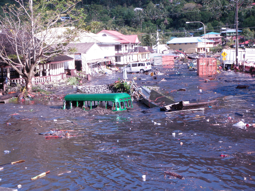
New Zealand is not alone in this: A lack of adequate natural seismic warning likely applies for major earthquake scenarios in other regions of the Pacific. Thus, for effective tsunami early warning, self-evacuation messaging must be supplemented with scientific monitoring and alerting mechanisms to protect vulnerable coastal populations living close to tsunami sources (Figure 3). The new array of tsunameters provides both a definitive path to improving societal resilience to tsunamis and a test bed for next-generation tsunami forecasting techniques.
Acknowledgments
Underpinning science for this work was funded by the New Zealand Royal Society’s Marsden Fund.
References
Angove, M., et al. (2019), Ocean observations required to minimize uncertainty in global tsunami forecasts, warnings, and emergency response, Front. Mar. Sci., 6, 350, https://doi.org/10.3389/fmars.2019.00350.
Fry, B., K. R. Gledhill, and R. A. Benites (2018), Ground motions in New Zealand from Kermadec megathrust earthquakes, GNS Sci. Rep. 2018/33, 17 pp., GNS Sci., Lower Hutt, New Zealand, https://doi.org/10.21420/7J43-G338.
Author Information
Bill Fry ([email protected]), GNS Science, Wellington, New Zealand; Sarah-Jayne McCurrach, Earthquake Commission, Wellington, New Zealand; previously at National Emergency Management Agency, Wellington, New Zealand; Ken Gledhill, GNS Science, Wellington, New Zealand; also at National Emergency Management Agency, Wellington, New Zealand; William Power, GNS Science, Wellington, New Zealand; Mike Williams, National Institute of Water and Atmospheric Research, Wellington, New Zealand; and Mike Angove, Diego Arcas, and Chris Moore, National Oceanic and Atmospheric Administration, Silver Spring, Md.
Citation:
Fry, B., S.-J. McCurrach, K. Gledhill, W. Power, M. Williams, M. Angove, D. Arcas, and C. Moore (2020), Sensor network warns of stealth tsunamis, Eos, 101, https://doi.org/10.1029/2020EO144274. Published on 26 May 2020.
Text © 2020. The authors. CC BY-NC-ND 3.0
Except where otherwise noted, images are subject to copyright. Any reuse without express permission from the copyright owner is prohibited.