• About
  • Special Reports
  • Topics
    • Climate
    • Earth Science
    • Oceans
    • Space & Planets
    • Health & Ecosystems
    • Culture & Policy
    • Education & Careers
    • Opinions
  • Projects
    • Postcards From the Field
    • ENGAGE
    • Editors’ Highlights
    • Editors’ Vox
    • Eos en Español
    • Eos 简体中文版
    • Print Archive: 2015–2025
  • Policy Tracker
  • Blogs
    • Research & Developments
    • The Landslide Blog
  • Newsletter
  • Submit to Eos
  • AGU.org
  • Career Center
  • Join AGU
  • Give to AGU
  • About
  • Special Reports
  • Topics
    • Climate
    • Earth Science
    • Oceans
    • Space & Planets
    • Health & Ecosystems
    • Culture & Policy
    • Education & Careers
    • Opinions
  • Projects
    • Postcards From the Field
    • ENGAGE
    • Editors’ Highlights
    • Editors’ Vox
    • Eos en Español
    • Eos 简体中文版
    • Print Archive: 2015–2025
  • Policy Tracker
  • Blogs
    • Research & Developments
    • The Landslide Blog
  • Newsletter
  • Submit to Eos
Skip to content
  • AGU.org
  • Career Center
  • Join AGU
  • Give to AGU
Eos

Eos

Science News by AGU

Support Eos
Sign Up for Newsletter
  • About
  • Special Reports
  • Topics
    • Climate
    • Earth Science
    • Oceans
    • Space & Planets
    • Health & Ecosystems
    • Culture & Policy
    • Education & Careers
    • Opinions
  • Projects
    • Postcards From the Field
    • ENGAGE
    • Editors’ Highlights
    • Editors’ Vox
    • Eos en Español
    • Eos 简体中文版
    • Print Archive: 2015–2025
  • Policy Tracker
  • Blogs
    • Research & Developments
    • The Landslide Blog
  • Newsletter
  • Submit to Eos

forecasting

Posted inNews

Roger Lhermitte (1920–2016)

by E. Williams 22 May 201825 February 2022

This luminary in the field of weather radar did it all, from basic engineering to sophisticated analysis.

Sea level rise on a reef-lined island coast
Posted inScience Updates

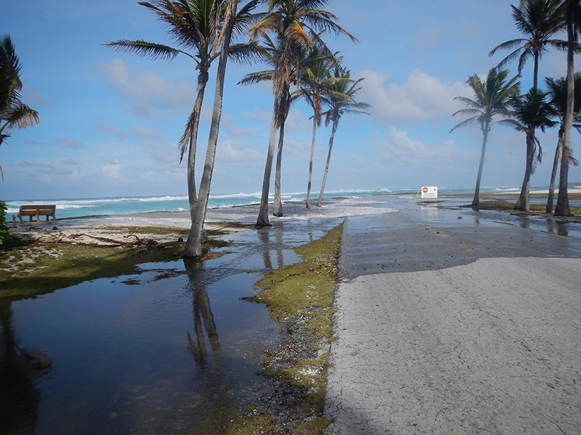
Challenges of Forecasting Flooding on Coral Reef–Lined Coasts

by C. D. Storlazzi 16 May 20183 October 2022

Understanding Flooding on Reef-lined Island Coasts Workshop; Honolulu, Hawaii, 5–7 February 2018

Researchers improve climate models by including Himalayan topography and land-atmosphere interactions.
Posted inResearch Spotlights

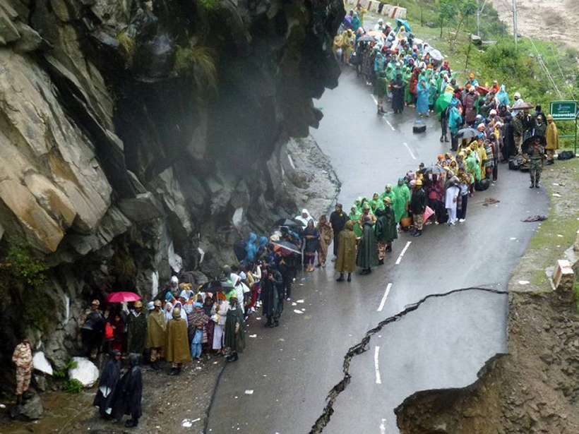
A Better Way to Predict the Indian Monsoon

by E. Underwood 4 May 201815 February 2023

A new study finds that including Himalayan topography and land-atmosphere interactions improves climate models.

Researchers use satellite data to calculate how fast the Nile Delta is sinking
Posted inResearch Spotlights

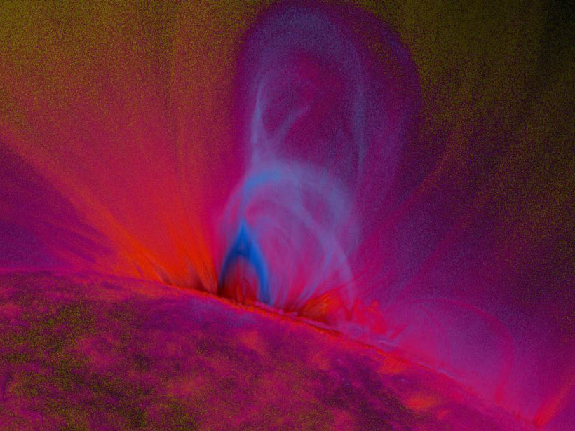
Capturing Structural Changes of Solar Blasts en Route to Earth

Sarah Stanley, Science Writer by Sarah Stanley 25 April 20184 May 2022

Comparison of magnetic field structures for 20 coronal mass ejections at eruption versus Earth arrival highlights the importance of tracking structural evolution to refine space weather predictions.

A 28 January 2014 snowstorm brought traffic in Birmingham, Ala., to a standstill.
Posted inScience Updates

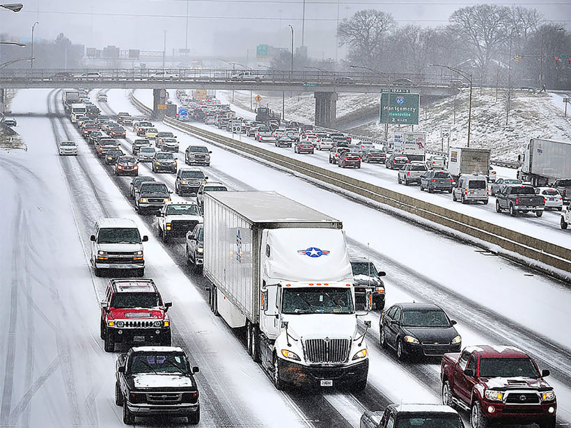
Snowfall Rates from Satellite Data Help Weather Forecasters

by R. Ferraro, H. Meng, B. Zavodsky, S. Kusselson, D. Kann, B. Guyer, A. Jacobs, S. Perfater, M. Folmer, J. Dong, C. Kongoli, B. Yan, N.-Y. Wang and L. Zhao 23 April 201818 February 2022

A new data product calculates snowfall rates from weather data beamed directly from several satellites, helping meteorologists provide fast, accurate weather reports and forecasts.

Aerial view of Pakistani flood survivors isolated on a road surrounded by water on 14 September 2010.
Posted inScience Updates

Atmospheric Teleconnections: Advanced Tools and Citizen Science

by E. Rousi, D. Coumou and R. V. Donner 17 April 201814 April 2023

GOTHAM International Summer School on Global Teleconnections in the Earth’s Climate System – Processes, Modelling and Advanced Analysis Methods; Potsdam, Germany, 18–22 September 2017

Posted inEditors' Vox

Diversity of El Niño Variability Makes Prediction Challenging

by S.-W. Yeh 26 March 20188 March 2022

The atmospheric response to El Niño, both in the Pacific region and around the world, changes with each event and is uncertain in future under the influence greenhouse gas forcing.

Posted inEditors' Highlights

Improving Temperature Forecasts in the Upper Atmosphere

by D. J. Knipp 19 March 201810 February 2023

Scientists are blending output from multi-year model runs to improve temperature forecasts in regions where satellites experience “drag,” in the hopes of avoiding future spacecraft collisions.

View from the International Space Station of lightning in Tropical Cyclone Bansi as it travels over the Indian Ocean in 2015.
Posted inScience Updates

Monitoring Tropical Cyclones with Lightning and Satellite Data

by N. N. Solorzano, J. N. Thomas and C. Bracy 19 February 201831 March 2023

A new storm-following tool continually watches for lightning over the open ocean. Combined with satellite microwave data, the new real-time observations will improve forecasts of tropical cyclones.

Drought is an absence of water but it is actually a complex phenomenon and one of the most poorly understood natural hazards
Posted inEditors' Vox

The Challenges of Drought Prediction

by Z. Hao 16 February 20186 February 2023

Advances in dynamical modeling and the use of hybrid methods have improved drought prediction, but challenges still remain to improve the accuracy of drought forecasting.

Posts pagination

Newer posts 1 … 16 17 18 19 20 … 27 Older posts
Over a dark blue-green square appear the words Special Report: The State of the Science 1 Year On.

Features from AGU Publications

Research Spotlights

Improving Eddy Tower Evapotranspiration Estimates

20 May 202620 May 2026
Editors' Highlights

Recycled Rocks Reveal Subduction Zone Dynamics Off Baja California

21 May 202621 May 2026
Editors' Vox

The Impact of Advocacy: American Geophysical Union’s Days of Action

14 May 202613 May 2026
Eos logo at left; AGU logo at right

About Eos
ENGAGE
Awards
Contact

Advertise
Submit
Career Center
Sitemap

© 2026 American Geophysical Union. All rights reserved Powered by Newspack