For decades, scientists have debated how earthquakes can occur in the hot, dense mantle beneath continents.
Most earthquakes happen in Earth’s brittle upper crust, where rocks snap under pressure. But as depth increases, temperatures rise, and rocks start to deform by ductile flow rather than break.
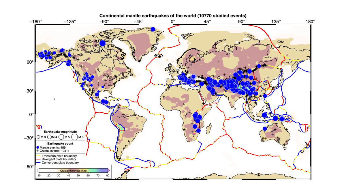
Now, in a study published in Science, geophysicists at Stanford University have compiled the first comprehensive global map of 459 continental mantle earthquakes (CMEs). CMEs describe extremely rare earthquakes that originate below the Mohorovičić discontinuity (the Moho), the boundary between Earth’s crust and its mantle.
As it turns out, crossing the Moho means encountering rock with a “much higher melting point,” said Simon Klemperer, a geophysicist and professor at Stanford and coauthor of the new study. Rocks with higher melting points stay solid at hotter temperatures, meaning the mantle can remain strong enough to break.
The idea that the continental crust and mantle have varying strengths helped shape the “jelly sandwich” model of the lithosphere: a brittle upper crust capable of earthquakes, a soft middle layer, and a stronger upper mantle below. For years, the jelly sandwich framework dominated textbooks.
A strong upper mantle implies that earthquakes can sometimes occur below the Moho, yet skepticism remained until 2013, when a magnitude 4.8 earthquake struck Wyoming at a depth of 75 kilometers (47 miles), an event later confirmed to be a mantle earthquake. “Everyone around the world could see at once. Yes, this was below the Moho; it was in the mantle,” said Klemperer. After that, he continued, “the question wasn’t ‘Do these things happen in the mantle?’ but ‘How many, and where?’”
Hiding in Plain Sight
To build the map, the Stanford team started with a list of 46,616 continental earthquakes recorded since 1990 by the U.S. Geological Survey (USGS).
They then narrowed that list down to 10,770 candidates for mantle quakes by selecting only events with high-quality nearby earthquakes for comparison. For each quake, two types of seismic waves were analyzed: Lg waves, which are trapped and travel efficiently within the crust, and Sn waves, which propagate through the uppermost mantle.
The researchers compared the ratio of Sn to Lg wave amplitudes (Sn/Lg) of candidate events against ratios from nearby earthquakes recorded at the same stations. That comparison canceled out local distortions that would otherwise skew results. What they found was that CMEs consistently have higher Sn/Lg than crustal earthquakes and that this ratio can be diagnostic of events that took place below the Moho. Using this approach, the researchers cataloged 459 CMEs, many of which occurred in regions with no previous detections.
“It’s not just that these earthquakes are down there. It’s, What do they mean in terms of the geomechanics and geodynamics?”
The 459 events confirmed to be CMEs were plotted on a global map built on Earth Crustal Model 1, a crustal thickness model that identifies where the Moho sits in each region.
The map revealed CMEs far beyond where scientists had previously looked. The Alpine-Himalayan belt, long suspected to host deep mantle earthquakes, showed prolific activity. More surprising findings showed CMEs near Lake Baikal in Russia, along the Bering Strait, across southwestern China, and throughout the western United States, where southern Idaho emerged as the most CME-rich region in the lower 48 states.
“It’s not just that these earthquakes are down there,” Klemperer said. “It’s, What do they mean in terms of the geomechanics and geodynamics?”
Perhaps most striking was the CME pattern beneath the Tibetan Plateau. CMEs appeared almost entirely around the plateau’s edges, while its interior remained largely quiet—a distribution that hints at the deep structural boundary between the Indian and Eurasian plates.
For Marine Denolle, an associate professor at the University of Washington, what stood out was how many of these earthquakes had been hiding in plain sight. “These earthquakes are kind of everywhere,” said Denolle, who was not involved in the research. “There needs to be new studies—more comprehensive, broader scale—[and] more unifying theories about what exists there.”
Next Steps
The map also exposes a fundamental problem with how earthquake catalogs have been built, the researchers said. Standard global catalogs routinely assign default depths to earthquakes that have little to do with where the quakes actually occurred. “The default depths from networks are 10 kilometers, 30 kilometers. But they’re defaults—they have nothing to do with the truth,” Denolle said.
Klemperer and his team reclassified the miscataloged events and are already extending their research into new territory. One cluster of CMEs beneath the Tibetan Plateau appears to trace the edge of the Indian plate as it plunges beneath Asia, mapping out where cold Indian crust ends and the mantle begins. Another group of earthquakes hints at something even more dramatic—a blob of dense crust slowly detaching and sinking under its own weight. The phenomenon looks “like it’s just a drip,” Klemperer said.
Most puzzling of all is an earthquake recently identified at a depth of 120 kilometers (75 miles). That is far beyond where any model predicts rocks should be able to break. One possible explanation, Klemperer said, is thermal runaway, a process in which localized shear heating destabilizes otherwise ductile rock enough to trigger sudden rupture.
—Larissa G. Capella (@CapellaLarissa), Science Writer