Want to learn more about Earth’s history from trusted experts?
Preference Eos in your searches!
Hundreds of millions of years ago, Antarctica’s climate resembled a tropical forest. It was humid, warm, and abundant in plant and animal life.
But then, something shifted. Around 34 million years ago, glaciers developed over East Antarctica, eventually forming the icy, cold landscape we know today. But what sparked the formation of these glaciers has been somewhat of a mystery.
“It’s really quite cool—we could be seeing this threshold whereby the interior of Antarctica became way more susceptible to forming an ice sheet.”
The initiation, growth, and stabilization of the East Antarctic Ice Sheet “is a very important problem that I don’t think is well understood,” said John Goodge, a geologist at the University of Minnesota Duluth who studies Antarctica’s past.
A new study offers a new explanation: Land uplift that resulted from a rift during the Jurassic period, 201–143 million years ago, may have created a high-elevation site with conditions ripe for glacier formation tens of millions of years later.
“About 50 million years ago, we had a major change in the highlands because of the uplift,” said Thomas Gernon, an Earth scientist at the University of Southampton and lead author of the new study, which was published in Science. “It’s really quite cool—we could be seeing this threshold whereby the interior of Antarctica became way more susceptible to forming an ice sheet.”
The new research “has really highlighted the importance of tectonics” in driving changes such as ice sheet growth, said Goodge, who was not involved in the new study. “This is a nice way to not only recognize the multiple drivers [of glaciation] but also to look back on the tectonic history of East Antarctica to see what could have conceivably kicked things off.”
Clues from Africa
Gernon didn’t set out, at first, to study the origins of the East Antarctic Ice Sheet. Instead, he wanted to see whether Antarctica’s geologic history matched that of another continent: Africa. In a 2024 study published in Nature, he and others reported that southern Africa’s high escarpments and plateaus were the result of so-called mantle waves spurred by tectonic rifting events during the breakup of the Gondwana supercontinent in the Jurassic period. These mantle waves spread beneath continents, radiating out from rifting events. Among other effects, mantle waves can remove rock from the lithosphere over millions of years, allowing the remaining rock to lift up.
“When you have bits of the continent falling off, you get a surface response—you get uplift, [erosion], and in the case of [southern] Africa, you get this anomalously high elevation,” Gernon said.
Gernon wondered whether the mantle wave process could also apply to Antarctica, which bordered what is now southern Africa within Gondwana.
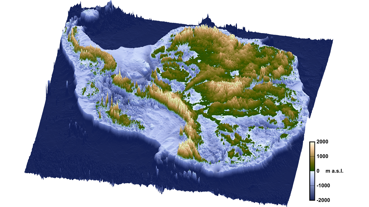
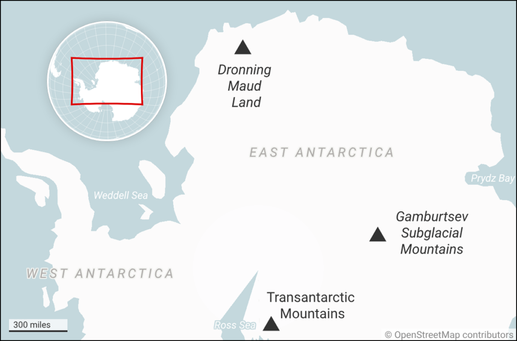
He bought a paper map of Antarctic topography and was immediately struck by the similarities. Just as he’d seen in South Africa, a portion of the Antarctic coastline called Queen Maud Land (Dronning Maud Land) had a steep escarpment up against a large, high-elevation plateau that eventually ran into the Gamburtsev Subglacial Mountains, an enigmatic mountain range long thought to be the origin site of the East Antarctic Ice Sheet.
“I could not believe what I saw,” Gernon said. “I thought, ‘It looks just like Africa.’”
It seemed that the landscape processes affecting both continents “were very much similar” as a result of rifting and the mantle wave process.
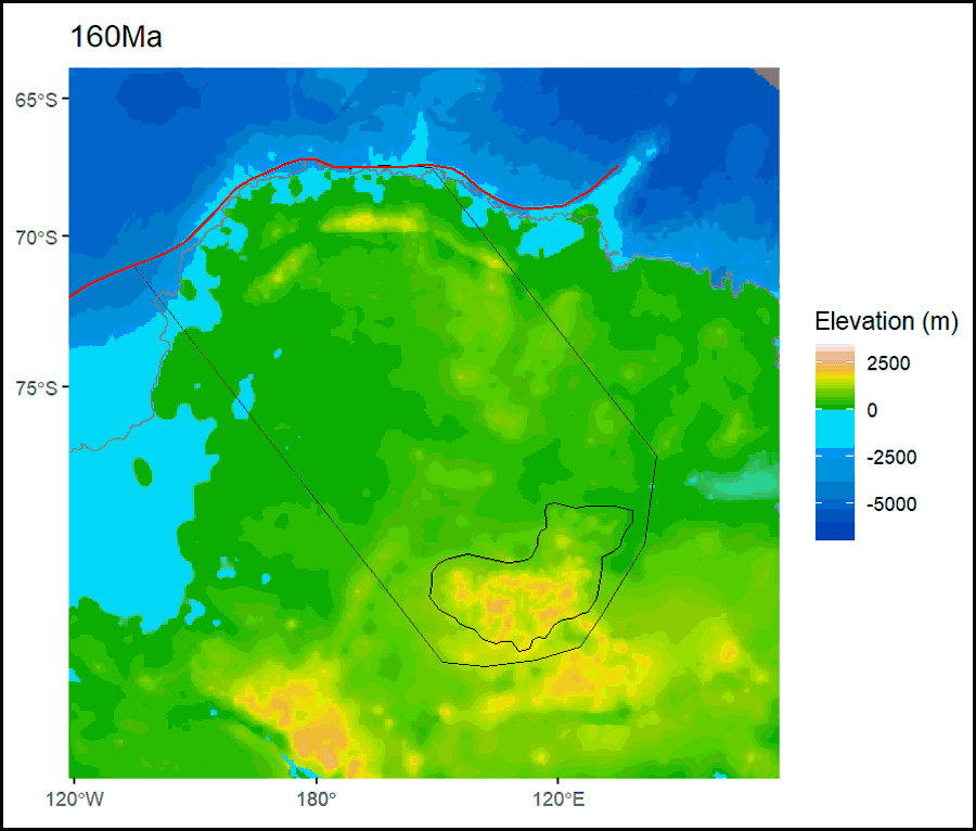
With these processes in mind, Gernon and the research team created a new computer simulation to model how the breakup of Gondwana could have eventually changed East Antarctica’s topography via mantle waves over tens of millions of years. Their models reflected topography very similar to East Antarctica’s real-world form.
“By virtue of just having the same process as in Africa, we could generate a topography which is actually really close to the topography that we observe in East Antarctica,” Gernon said.
Because the uplift was observed in the Gamburtsev Subglacial Mountains—long considered the formation site of what would become the East Antarctic Ice Sheet—the research team began to wonder whether their model could explain the formation of the ice sheet too. “Could these highlands be playing a huge role?” Gernon remembers thinking.
Uplift and Glaciation
To test that idea, the research team created two other models: one to determine how sensitive ice sheet formation was to the changing topography of East Antarctica and another that considered the whole picture of topographic and climatic changes that scientists think were likely to have occurred in Antarctica’s past. They found in both cases that the topographic changes they had modeled, caused by the mantle wave and subsequent uplift process, made the uplifting Gamburtsev Subglacial Mountains more sensitive to changes in temperature and more likely to accumulate ice.
In the study, the researchers argue that once the Gamburtsev Subglacial Mountains became high enough, snow and ice were able to accumulate year-round between the mountain peaks, setting off a feedback loop that cooled Antarctica even further. Their modeling showed that this process may have begun as early as 40 million years ago, earlier than most scientists think the East Antarctic Ice Sheet began to form.
“It’s kind of inspiring to think that a tectonic chain reaction 100 million years ago could have an impact more recently.”
“It’s kind of inspiring to think that a tectonic chain reaction 100 million years ago could have an impact more recently,” Gernon said. The results also explain the mystery of why Antarctica developed glaciers before the Arctic did, even though both poles were subject to global cooling, he said. “The answer, we think, is because Antarctica was uplifting and generating very large, [high] areas” that allowed ice sheet formation to gain a head start, he said.
“The paper makes a very compelling case that it is this tectonic response, building over some period of tens of millions of years, that leads to a threshold situation where this high-elevation terrain reaches a critical elevation where it can permanently allow ice to form,” Goodge said.
Analyzing the properties of the lithosphere below the Gamburtsev Subglacial Mountains could help verify the researchers’ models. However, such data are difficult to obtain because these highlands are covered by thick ice. For a 2022 study, Goodge and a colleague sampled glacial debris that had possibly originated in the Gamburtsev Subglacial Mountains and supports Gernon’s modeling, but deep drilling into ice-covered rock would allow for a better understanding of East Antarctica’s ice sheet history.
With deep drilling and more sustained support for international science, “we’d be able to learn a great deal more,” Gernon said.
—Grace van Deelen (@gvd.bsky.social), Staff Writer