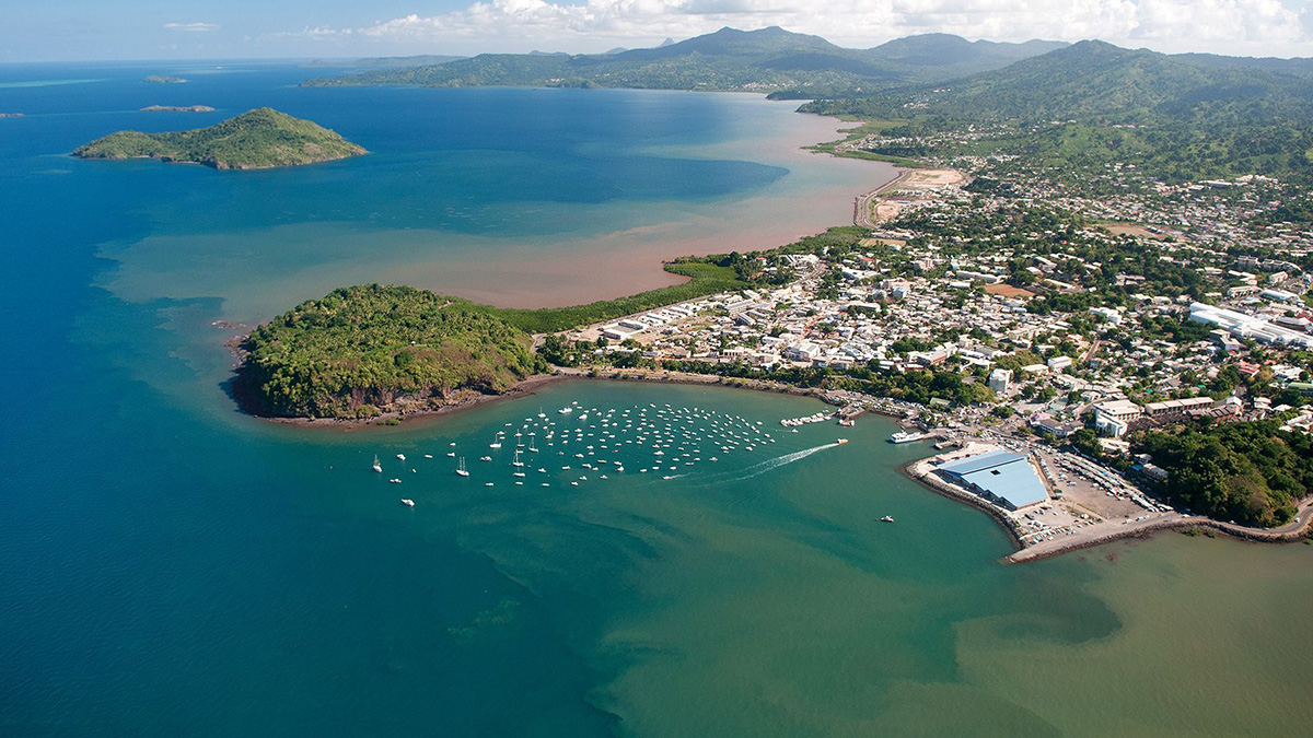

On 10 May 2018, an unprecedented bout of earthquake activity began in the vicinity of Grande-Terre, the main island in the French overseas region of Mayotte, located in the Indian Ocean between northern Mozambique and Madagascar. The ensuing seismic swarm, which shook the island repeatedly, included events up to magnitude 5.9 as well as long-lasting very low frequency earthquakes [Lemoine et al., 2020; Cesca et al., 2020]. More than 3 years later, the nearly 300,000 residents of Mayotte still cannot rest easy as the intense offshore activity continues to be unpredictable.
Adding to the hazard facing Mayotte (a name that is often used to refer to the island of Grande-Terre as well as the surrounding region) is a new volcano rising more than 820 meters from the seafloor 50 kilometers east of Grande-Terre. The volcano formed when some 5 cubic kilometers of fresh lava, almost 9 times the volume of Sydney Harbor, began erupting onto the seafloor in July 2018. This volume is equivalent to about a quarter of the long-term average amount emplaced annually from the entire mid-ocean ridge system; the eruption therefore emitted a considerable amount of carbon dioxide [Feuillet et al., 2021]. As a result of the eruption—and the emptying and deflation of magma chambers deep below the volcano—the island underwent major subsidence and shifted eastward [Lemoine et al., 2020; Cesca et al., 2020].
Even under the best conditions, ensuring that ocean bottom seismometers (OBSs) land safely at target positions on the seafloor is difficult.
A puzzling observation was that the concurrent seismic activity was not near the birthplace of the new volcanic edifice, as scientists initially expected, but was instead several tens of kilometers west of there, nearer to Mayotte [Saurel et al., 2022]. This region of seismic activity has shown evidence of degassing from the seafloor since the main eruption, indicating that subsurface magmatism is ongoing [Feuillet et al., 2021].
Naturally, there has been great interest recently in studying and monitoring the area, out of concern for the safety of local residents [Devès et al., 2021] and to gain a better scientific understanding of what’s happening belowground [e.g., Aiken et al., 2021]. Ocean bottom seismometers (OBSs) are valuable tools for imaging subseafloor structure and monitoring internal activity, particularly during seismic or volcanic crises. Even under the best conditions, though, ensuring that OBSs land safely at target positions on the seafloor is difficult. Conventionally, the instruments are dropped from a ship into the ocean, where they free-fall through the water column. In deep waters, strong currents can carry them long distances from their targeted positions, and they may settle on unfriendly or hazardous terrain.
With the intense seismic and volcanic crisis near Mayotte, the area offers significant challenges, to say the least, for deploying an underwater seismic observatory. However, in April 2021, we successfully tested a ballasted metal cage that allowed us to position six OBSs on the seafloor safely, precisely, and quickly to ensure that they could collect optimal recordings of ongoing seismic activity. The work was part of an unprecedented effort to turn the unexpected events near Mayotte since 2018 into a major scientific opportunity.
A New Campaign to Study the Seismicity
Mayotte is part of the Comoros archipelago, an east–west oriented cluster of volcanic islands in the Mozambique Channel. The islands are south of the Somalia Basin, which opened during the Mesozoic as Madagascar detached from Africa and drifted southward. However, the volcanism of the Comoros archipelago is much younger—no older than Miocene in age—and is thought to have occurred along the transfer zone, where deformational strain is transmitted between the East African and Madagascar rift systems [Feuillet et al., 2021].
Although we have broad knowledge of this region’s geologic history, there is much that we do not know about its crustal structure, magmatic systems, and seismic constraints, all of which build the area’s landscape and are connected to natural hazards.
Over its 21 cruises so far, the Mayotte OBS (MAYOBS) research consortium has repeatedly monitored the seismic and volcanic activity near Mayotte with the goal of holistically studying their causes and consequences.
In spring 2019, several French research organizations—including the Institut Français de Recherche pour l’Exploitation de la Mer (IFREMER), Bureau de Recherches Géologiques et Minières, Institut de Physique du Globe de Paris, and Centre National de la Recherche Scientifique—launched the Mayotte Ocean Bottom Seismometers (MAYOBS) oceanic surveying campaign under the multidisciplinary Réseau de Surveillance Volcanologique et Sismologique de Mayotte (REVOSIMA) initiative.
Over its 21 MAYOBS cruises so far, the research consortium has repeatedly monitored the seismic and volcanic activity near Mayotte with the goal of holistically studying its causes and consequences. The group is specifically interested in illuminating how magma, ascending through volcanic plumbing networks and recharging reservoirs, reaches the seafloor [e.g., Berthod et al., 2021a, 2021b; Foix et al., 2021], where it shapes new relief, spreads chemical volatiles like carbon dioxide into the water column, and affects surrounding ecosystems. A dramatic example of such effects has been shown by discoveries by local sailors of dead deepwater fish rising to the surface.
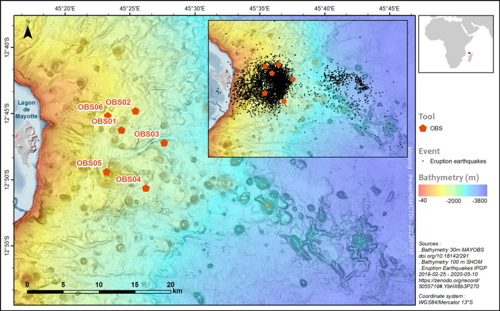
The MAYOBS 18 cruise in April 2021 targeted the highly active Horseshoe area just 10 kilometers offshore eastern Mayotte to study weak seismic signals generated by fluids, magma, and gas circulating inside the local volcanic plumbing system (Figure 1). These signals are essential in helping us understand the system’s architecture and how it operates, and they may allow us eventually to forecast future volcanic events. To record these faint drumbeats, we planned to deploy six OBSs during the cruise to water depths between 1,470 and 2,130 meters.
A first step, though, was to overcome logistical and health protocols imposed because of the COVID-19 pandemic, which are particularly strict for those embarking on oceanographic missions. All participants had to self-isolate at home for 15 days before their flight to Réunion Island, where, upon arrival, they boarded a bus that transported the scientific staff and sailors directly to the ship without any contact with the local population. Once on board, a further 7-day precautionary period of wearing masks and limiting interactions among personnel was strictly imposed. Finally, at the end of this period, normal operations could resume—a beautiful moment of tension release and relief (although we had to repeat the process in reverse on the return home). Despite the complications, we completed our operations within the planned time frame.
Hitting a Deep, Dark Target
Before deploying the OBSs, the onboard team carefully analyzed high-resolution bathymetry of the area to find sites where the ground slope was less than 5° (Figure 1), the maximum inclination allowed by instrumentation (specifically the horizontal geophones) in our OBSs. The team also looked for sites that were not at high risk of new volcanic eruptions and where the seafloor topography was not rough from previous lava flows to ensure the instruments would record properly and remain safe. Even with such planning, positioning these instruments precisely is a huge challenge.
Remotely operated vehicles (ROVs) are generally used for this task in offshore industries (e.g., in the petroleum and cable-laying industries), but this option is often too expensive and time-consuming in academic research. On oceanographic cruises, researchers usually opt for the fastest way to deploy OBSs, dropping the instruments from the ship and letting them free-fall to the bottom of the ocean, with the understanding that highly variable ocean conditions, weather, currents, and eddies can cause trouble.
To overcome difficulties of OBS deployment, our team designed a ballasted cage and tested it during the MAYOBS 18 cruise.
Further, the risk that instruments land on undesired terrain is increased in areas of rough or steep seafloor, such as at subduction zones, mid-ocean ridges, and volcanic islands like Mayotte. Rough terrain may directly affect the instruments’ ability to operate correctly if they don’t settle properly. There is also a high risk of simply losing instruments in dark waters.
In the past, our team tried deploying OBSs attached to a cable. This technique offers more control over the final position of an instrument, but as with allowing an OBS to free-fall, the instrument’s relatively light weight in water slows its descent and means this option is still very time-consuming. To overcome these difficulties, our team designed a ballasted cage and tested it during the MAYOBS 18 cruise. The cage encloses the OBS, increasing the weight and descent speed of the instrument. An added benefit is that the cage’s steel fabrication is inexpensive and can easily be adapted to work with any oceanic instrument.
The cage was further equipped with an Ultra Short Baseline (USBL) underwater positioning system—like those often used on ROVs and autonomous underwater vehicles—featuring real-time tracking with a horizontal accuracy of 0.1% of the water depth (e.g., 1-meter accuracy at a depth of 1,000 meters).
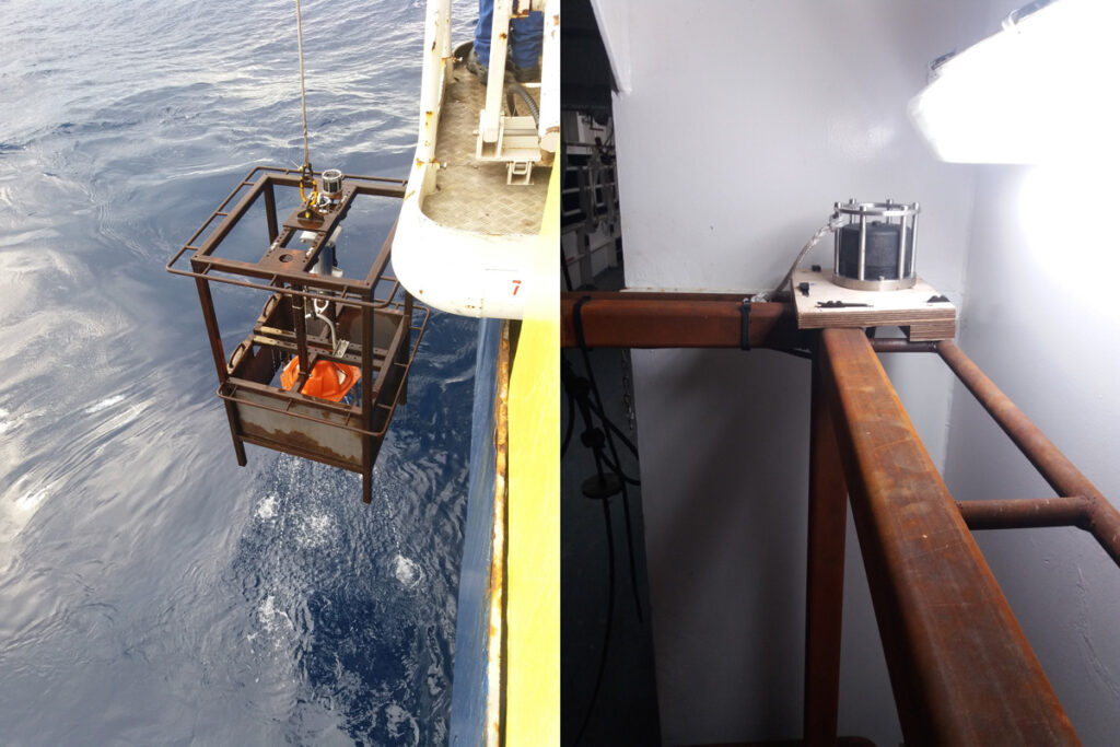
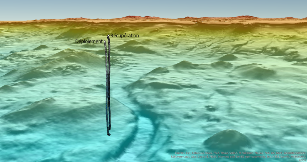
Our USBL system also included a removable acoustic transmitter—a feature that would prove important in our deployments—and a release function. Together with the dynamic positioning capabilities of our ship, the R/V Pourquoi Pas?, the communications package on the cage allowed us to control precisely in real time the horizontal positioning of the cage as it was lowered on its cable from the ship’s winch and to remain above the target during its descent. The OBSs were released from their cages to free-fall from about 10 to 20 meters above the seafloor, and the cages were then quickly returned to the ship at the maximum speed of the winch (1.5 meters per second).
Finer, Faster, and Safer Deployment
Our first three deployments were a little erratic. The real-time positioning indicated many communication interruptions and uncontrolled jumps in the estimated positions of the cage during these descents. Although we ultimately released the OBSs at the correct locations, it took us longer than expected because we sometimes had to wait for the position of the cage to stabilize and we did not use the winch at full speed.
It turned out that the steel frames of the cage were interfering with the USBL communications because the acoustic transmitter was located at the center of the cage. To mitigate this effect, during the next three deployments, we affixed the acoustic transmitters to an outer corner of the cage. We also separated them from the metal frames with a wooden plate, which provided important acoustic and mechanical decoupling from the cage and further attenuated interference. With this setup, our communication with the USBL was unimpeded, and we could deploy the OBSs faster and more smoothly.
Considering the accuracy of the USBL system and assuming instrument drift during its final 10- to 20-meter free fall of about 10%, we estimated the accuracy of the final measured positions of the deployed OBSs to be ±5 meters at water depths between 1,470 and 2,130 meters. An instrument’s final position on the seafloor with respect to the targeted position strongly depends, however, on the ability of the ship to control its position and keep the cage at the needed location.
During our experiment, using accurate dynamic ship positioning and with calm seas and moderate winds, we dropped each of our six instruments to within 5–35 meters of the targeted positions. By comparison, letting an OBS free-fall through the entire water column, which doesn’t allow any control once it is released, often leads to final positions several hundreds of meters—or even more than a kilometer when currents are strong—from targeted sites. Our precise and safe deployments took about 45 minutes each, including the descent down to 1,500–2,000 meters water depth and the retrieval of the empty cage back on deck, an improvement of roughly an hour compared with conventional OBS deployments.
The Steadfast Seismometer
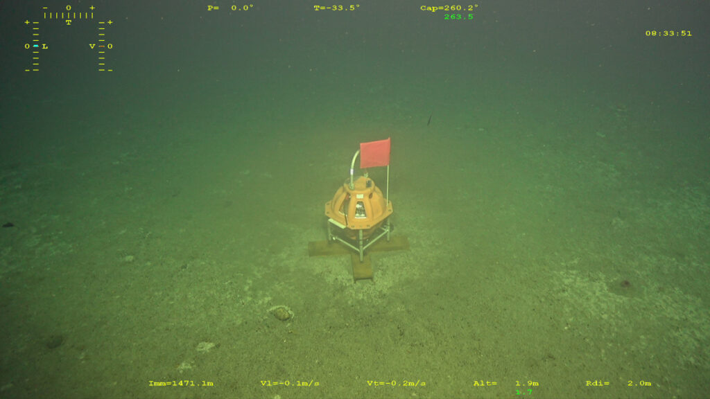
During the subsequent cruise of the Geochemistry, Fluids, Acoustic Anomalies, and Magmatic Activity Following the Mayotte Eruption (GEOFLAMME) program (April through May 2021), which was dedicated to exploring for and sampling lava, fluids, and gas emitted at the seafloor near Mayotte, IFREMER’s Victor 6000 ROV dived to the location of one of the MAYOBS 18 OBS deployments. The ROV photographed the OBS standing on flat, smooth seafloor, out of danger, as expected, and in the same position as when it was released from the cage.
The six instruments were recovered a few months after their deployment during the MAYOBS 20 cruise. The OBSs are made of buoyant, hermetically sealed glass spheres that enclose sensors, batteries, data recorders, and all the necessary electronics. We need that sphere to come back to the surface to download and process the recorded data.
The successful deployment and 100% retrieval of the OBSs, combined with the decreased deployment times, confirmed our overall data collection strategy as well as the usefulness of the ballasted cage.
During the MAYOBS 20 cruise, acoustic signals were sent to the instruments, causing them to detach from their anchors and allowing the glass spheres to rise to the surface. After a tense half hour to hour of waiting on the ship for each instrument, all of them were recovered with the valuable data they collected. The successful deployment and 100% retrieval of the OBSs, combined with the decreased deployment times, confirmed our overall data collection strategy as well as the usefulness of the ballasted cage we designed.
Although the cage was developed for OBSs, only minor adjustments are required for its use in accurately deploying other scientific instruments to the seabed. Moreover, real-time tracking of the cages could provide supplemental ocean data, helping us to measure and understand local deepwater currents. Deployment times could also easily be reduced further (which would reduce drift), either by increasing the weight of the cage with additional ballast or by using a state-of-the-art winch capable of operating at higher speeds.
In the wake of the expedition in spring 2021, scientists at IFREMER and partner institutions are analyzing and making use of the data collected. They are working to understand how underwater ecosystems are adapting to brutal changes wrought by volcanism, from the massive lava flows reshaping the seafloor to the emitted volatiles altering oceanic chemistry. They are also tracking seismic signals that could help them to better characterize the shape and functioning of the volcanic plumbing system as well as the risks it poses to humans.
The January magmatic event at the Hunga Tonga–Hunga Ha’apai seamounts provided a fresh reminder of such risks. This activity led to an explosive eruption and the collapse of a large part of the volcanic edifice, which triggered a tsunami that quickly reached the populated islands of Tonga before progressing to islands and coasts farther away. Fortunately, tsunami warnings were issued, and few casualties were reported, although damage in Tonga was extensive.
We hope, of course, that there will be no catastrophic effects from the ongoing activity near Mayotte. But to help ensure safety, this activity is still being carefully monitored, and regular reports are made available through REVOSIMA to locals and the global public. Additional MAYOBS campaigns are also planned for the near future to continue addressing both safety concerns and scientific questions in the region.
Acknowledgments
We thank Gaelle Lamarque and Mikael Evain for fostering the development of the cage. We also thank the captain and crew of the R/V Pourquoi Pas? and the scientists mobilized during the MAYOBS18 cruise who made these deployments possible. We gratefully acknowledge Mathilde Pitel Roudaut, Nina Tangy, and Alison Chalm from IFREMER for creating illustrations used in this article and for help writing in English. We thank Emmanuel Rinnert, Nathalie Feuillet, and Cécile Cathalot, principal investigators of the GEOFLAMME cruise, for providing the underwater photograph of one of our OBSs taken from ROV Victor 6000. Since June 2019, all activities on Mayotte have been supported by the Ministère de l’Enseignement Supérieur, de la Recherche et de l’Innovation, the Ministère de la Transition Ecologique, the Ministère des Outremers, the Ministère de l’Intérieur, and the Ministère des Armées with the support of the Direction Interministérielle aux Risques Majeurs en Outremer. All marine operations are performed as part of the MAYOBS set of cruises, and we thank the captains and crews of the R/V Pourquoi Pas?. Data from these cruises are available at campagnes.flotteoceanographique.fr/series/291/.
References
Aiken, C., J.-M. Saurel, and O. Foix (2021), Earthquake location and detection modeling for a future seafloor observatory along Mayotte’s volcanic ridge, J. Volcanol. Geotherm. Res., 418, 107322, https://doi.org/10.1016/j.jvolgeores.2021.107322.
Berthod, C., et al. (2021a), The 2018-ongoing Mayotte submarine eruption: Magma migration imaged by petrological monitoring, Earth Planet. Sci. Lett., 571, 117085, https://doi.org/10.1016/j.epsl.2021.117085.
Berthod, C., et al. (2021b), Mantle xenolith-bearing phonolites and basanites feed the active volcanic ridge of Mayotte (Comoros archipelago, SW Indian Ocean), Contrib. Mineral. Petrol., 176(10), 75, https://doi.org/10.1007/s00410-021-01833-1.
Cesca, S., et al. (2020), Drainage of a deep magma reservoir near Mayotte inferred from seismicity and deformation, Nat. Geosci., 13(1), 87–93, https://doi.org/10.1038/s41561-019-0505-5.
Devès, M. H., et al. (2021), Risk communication successes and limits during sismo-volcanic crisis: The example of Mayotte, France, Nat. Hazards Earth Syst. Sci. Discuss., https://doi.org/10.5194/nhess-2021-164.
Feuillet, N., et al. (2021), Birth of a large volcanic edifice offshore Mayotte via lithosphere-scale dyke intrusion, Nat. Geosci., 14, 787–795, https://doi.org/10.1038/s41561-021-00809-x.
Foix, O., et al. (2021), Offshore Mayotte volcanic plumbing revealed by local passive tomography, J. Volcanol. Geotherm. Res., 420, 107395, https://doi.org/10.1016/j.jvolgeores.2021.107395.
Lemoine, A., et al. (2020), The 2018–2019 seismo-volcanic crisis east of Mayotte, Comoros islands: Seismicity and ground deformation markers of an exceptional submarine eruption, Geophys. J. Int., 223(1), 22–44, https://doi.org/10.1093/gji/ggaa273.
Saurel, J.-M., et al. (2021), 2019-02-25 to 2020-05-10 Mayotte eruption earthquake catalog relocated with OBS, Zenodo, https://doi.org/10.18715/IPGP.2021.kq136bzh.
Saurel, J.-M., et al. (2022), Mayotte seismic crisis: Building knowledge in near real-time by combining land and ocean-bottom seismometers, first results, Geophys. J. Int., 228(2), 1,281–1,293, https://doi.org/10.1093/gji/ggab392.
Author Information
Pascal Pelleau, Ronan Apprioual, Antony Ferrant, and Daniel Aslanian ([email protected]), IFREMER, Brest, France