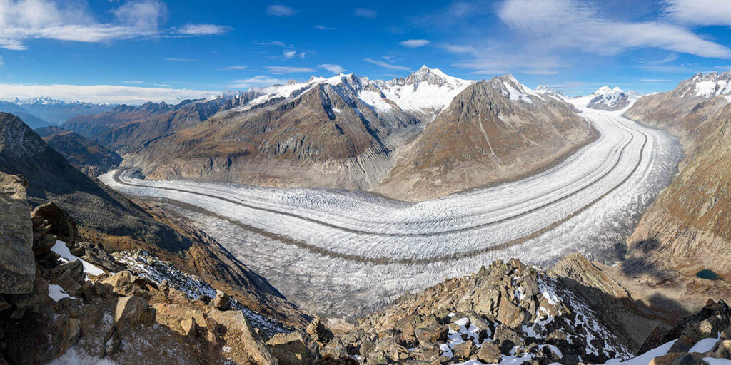
Shrinking glaciers present some of the most visible signs of ongoing anthropogenic climate change. Their melting also alters landscapes, increases local geohazards, and affects regional freshwater availability and global sea level rise.
Worldwide observations show that global glacier decline through the early 21st century has been historically unprecedented. Modeling research suggests that 16 kilograms of glacier ice melt for every kilogram of carbon dioxide (CO2) emitted, and other studies indicate that every centimeter of sea level rise exposes an additional 2–3 million people to annual flooding.
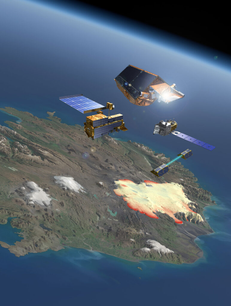
Science has benefited from a diverse set of spaceborne missions and strategies for estimating glacier mass changes at regional to global scales.
For more than 130 years, the World Glacier Monitoring Service and its predecessor organizations have coordinated international glacier monitoring. This effort started with the worldwide collection, analysis, and distribution of in situ observations [World Glacier Monitoring Service, 2023]. In the 20th century, remote sensing data from airborne and spaceborne sensors began complementing field observations.
Over the past 2 decades, science has benefited from a diverse set of spaceborne missions and strategies for estimating glacier mass changes at regional to global scales (see Figure 2 of Berthier et al. [2023]). However, this research is challenged by its dependence on the open accessibility of observations from scientific satellite missions. The continuation and accessibility of several satellite missions are now at risk, presenting potential major gaps in our ability to observe glaciers from space.
We discuss here the history, strengths, and limitations of several strategies for tracking changes in glaciers and how combining studies from the multiple approaches available—as exemplified by a recent large-scale effort within the research community—improves the accuracy of analyses of glacial mass changes. We also outline actions required to secure the future of long-term glacier monitoring.
The Glacier Mass Balance Intercomparison Exercise
Glaciological observations from in situ measurements of ablation and accumulation, generally carried out with ablation stakes and in snow pits, represent the backbone of glacier mass balance monitoring. For more than 30 years, glaciologists have undertaken this work at 60 reference glaciers worldwide, with some observations extending back to the early 20th century.
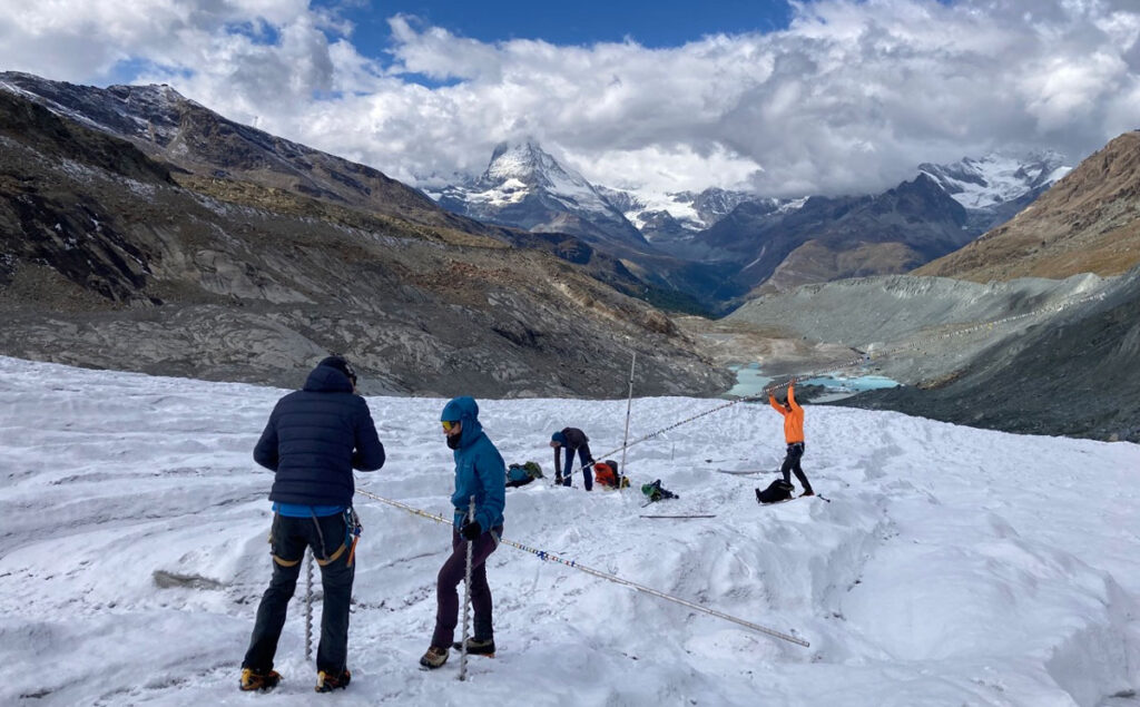
These observations provide good estimates of the interannual variability of glacier mass balance and have been vital for process understanding, model calibration, and long-term monitoring. However, because of the limited spatial coverage of in situ observations, the long-term trends they indicate may not accurately represent mass change across entire glacial regions, and some largely glacierized regions are critically undersampled.
Airborne geodetic surveys provide wider views of individual glaciers compared with point measurements on the ground, and comparing ice elevation changes in airborne data allows researchers to identify and quantify biases in field observations at the glacier scale [Zemp et al., 2013]. Meanwhile, geodetic surveys from spaceborne sensors enable many opportunities to assess glacier elevation and mass changes at regional to global scales.
The Glacier Mass Balance Intercomparison Exercise (GlaMBIE), launched in 2022, combined observations from in situ and remote sensing approaches, compiling 233 regional glacier mass change estimates from about 450 data contributors organized in 35 research teams.
The results of the Glacier Mass Balance Intercomparison Exercise show that since 2000, glaciers have lost between 2% and 39% of their mass depending on the region and about 5% globally.
The results of this community effort, published in February 2025, show that since 2000, glaciers have lost between 2% and 39% of their mass depending on the region and about 5% globally [The GlaMBIE Team, 2025]. These cumulative losses amount to 273 gigatons of water annually and contribute 0.75 millimeter to mean global sea level rise each year. Compared with recent estimates for the ice sheets [Otosaka et al., 2023], glacier mass loss is about 18% larger than the loss from the Greenland Ice Sheet and more than twice the loss from the Antarctic Ice Sheet.
GlaMBIE provided the first comprehensive assessment of glacier mass change measurements from heterogeneous in situ and spaceborne observations and a new observational baseline for global glacier change and impact assessments [Berthier et al., 2023]. It also revealed opportunities and challenges ahead for monitoring glaciers from space.
Strategies for Glacier Monitoring from Space
GlaMBIE used a variety of technologies and approaches for studying glaciers from space. Many rely on repeated mapping of surface elevations to create digital elevation models (DEMs) and determine glacier elevation changes. This method provides multiannual views of glacier volume changes but requires assumptions about the density of snow, firn, and ice to convert volume changes to mass changes, which adds uncertainty because conversion factors can vary substantially.
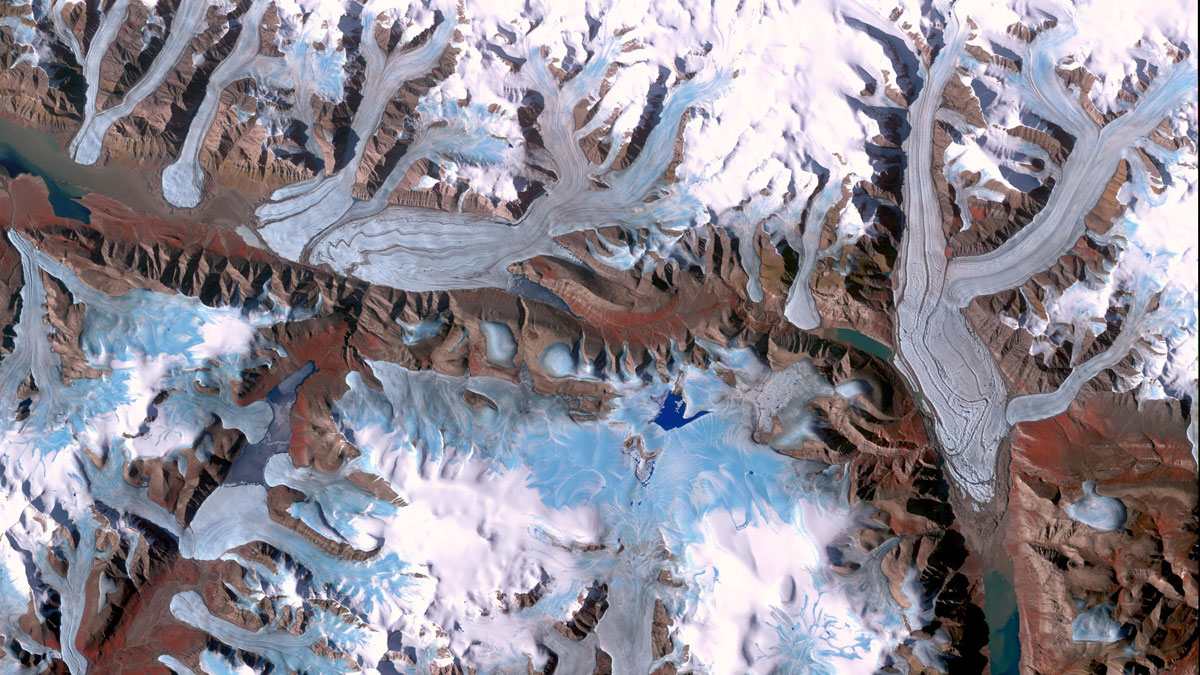
Optical stereophotogrammetry applied to spaceborne imagery allows assessment of glacier elevation changes across scales. Analysis of imagery from the Advanced Spaceborne Thermal Emission and Reflection Radiometer (ASTER) on board Terra from 2000 to 2019 yielded elevation changes at 100-meter horizontal resolution for almost all of Earth’s glaciers [Hugonnet et al., 2021]. At the regional scale, finer spatial resolution is possible with the ongoing French Satellite pour l’Observation de la Terre (SPOT) mission series and with satellites like GeoEye, Pléiades, and WorldView.
Two spaceborne missions applying synthetic aperture radar (SAR) interferometry have been used to assess glacier elevation changes. In February 2000, the Shuttle Radar Topography Mission (SRTM) produced a near-global DEM at a spatial resolution of 30 meters. The second mission, TerraSAR-X add-on for Digital Elevation Measurement (TanDEM-X), has operated since 2010, providing worldwide DEMs at a pixel spacing of 12 meters.
Data from both missions can be used to assess glacier elevation changes in many regions [Braun et al., 2019], capitalizing on the high spatial resolution and the ability of radar signals to penetrate clouds. However, measurements using C- and X-band radar—as both SRTM and TanDEM-X have—are subject to uncertainties because of topographic complexity in high mountain terrain and because the radar signals can penetrate into snow and firn.
Laser and radar altimetry allow us to determine glacier elevation changes along ground tracks or swaths, which can be aggregated to produce regional estimates. Laser altimetry has been carried out by NASA’s Ice, Cloud and Land Elevation Satellites (ICESat and ICESat-2) and the Global Ecosystem Dynamics Investigation (GEDI) on board the International Space Station (ISS) [Menounos et al., 2024; Treichler et al., 2019].
Spaceborne gravimetry offers an alternative to elevation-focused methods, allowing scientists to estimate mass changes by measuring changes in Earth’s gravitational field.
Spaceborne radar altimetry has a long tradition of measuring ocean and land surfaces, but these missions’ large detection footprints and the challenges of mountainous terrain hampered the use of early missions (e.g., ERS, Envisat) for glacier applications. The European Space Agency’s (ESA) CryoSat-2, which launched in 2010, offered improved coverage of the polar regions, denser ground coverage, a sharper footprint, and other enhanced capabilities that opened its use for monitoring global glacier elevation changes [Jakob and Gourmelen, 2023].
Both laser altimetry and radar altimetry provide elevation change time series at monthly or quarterly resolution for regions with large ice caps and ice fields (e.g., Alaska, the Canadian Arctic, Svalbard, and the periphery of the Greenland and Antarctic Ice Sheets). However, assessing mountain regions with smaller glaciers (e.g., Scandinavia, central Europe, Caucasus, and New Zealand) remains challenging because of the complex terrain and limited spatial coverage.
Spaceborne gravimetry offers an alternative to elevation-focused methods, allowing scientists to estimate mass changes across the ocean and in water and ice reservoirs by measuring changes in Earth’s gravitational field. Two missions, the NASA/German Aerospace Center Gravity Recovery and Climate Experiment (GRACE) and the NASA/GFZ Helmholtz Centre for Geosciences GRACE Follow-on mission (GRACE-FO), have provided such measurements almost continuously since 2002.
Gravimetry offers more direct estimates of glacier mass change than other methods [Wouters et al., 2019]. However, the data must be corrected to account for effects of atmospheric drag and oceanic variability, glacial isostatic adjustment, nonglacier hydrological features, and other factors [Berthier et al., 2023].
Estimates from the GRACE and GRACE-FO missions are most relevant for regions with large areas of glacier coverage (>15,000 square kilometers) because of the relatively coarse resolution (a few hundred kilometers) of the gravity data and because of issues such as poor signal-to-noise ratios in regions with small glacier areas and related small mass changes.
Securing Glacier Monitoring over the Long Term
The work of GlaMBIE to combine observations from the diverse approaches above points to several interconnected requirements and challenges for improving the comprehensiveness of global glacier change assessments and securing the future of long-term glacier monitoring.
First, we must extend the existing network of in situ glaciological observations to fill major data gaps. Such gaps remain in many regions, including Central Asia, Karakoram, Kunlun, and the Central Andes, where glaciers are vital for freshwater availability, as well as in the polar regions, where glaciers are key contributors to sea level rise. These networks also need to be updated to provide real-time monitoring, which will improve understanding of glacier processes and help calibrate and validate remote sensing data and numerical modeling.
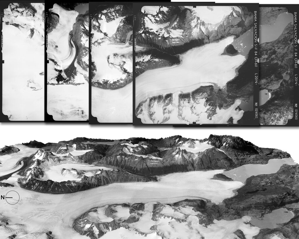
Second, we must continue unlocking historical archives of airborne and spaceborne missions to expand the spatiotemporal coverage of the observations used in glacier mass change assessments. Data from declassified spy satellites, such as CORONA and Hexagon, have provided stereo observing capabilities at horizontal resolutions of a few meters and offer potential to assess glacier elevation changes back to the 1960s and 1970s. Aerial photography has provided unique opportunities to reconstruct glacier changes since the early 20th century, such as in Svalbard, Greenland, and Antarctica. Beyond individual and institutional studies, we need open access to entire national archives of historical images to safeguard records of past glacier changes on a global scale.
We must ensure the continuation of space-based glacier monitoring with open-access and high-resolution sensors.
Third, we must ensure the continuation of space-based glacier monitoring with open-access and high-resolution sensors, following the examples of the Sentinel missions, SPOT 5, and Pléiades. For optical sensors, there is an urgent need for new missions collecting open-access, high-resolution stereo imagery. The French space agency’s forthcoming CO3D (Constellation Optique en 3D) mission, scheduled for launch in 2025, will help meet this need if its data are openly available. But with the anticipated decommissioning of ASTER [Berthier et al., 2024] and the suspended production of new ArcticDEM and REMA (Reference Elevation Model of Antarctica) products from WorldView satellite data as a result of recent U.S. funding cuts, additional replacement missions are needed to observe elevation changes over individual glaciers.
For radar imaging and altimetry, the SAR mission TanDEM-X and the radar altimeter CryoSat-2 are still operating with expected mission extensions into the late 2020s, and ESA’s SAR-equipped Harmony mission is expected to launch in 2029. With the planned launch of the Copernicus Polar Ice and Snow Topography Altimeter (CRISTAL) in 2027, ESA aims to establish a long-term, cryosphere-specific monitoring program.
The challenge with CRISTAL will be to ensure that its sensor and mission specifications are tailored for application over glaciers—a difficult task because of glaciers’ relatively small sizes, steep slopes, and distribution in mountain terrain. In the event of a gap between the end of CryoSat-2 and the start of CRISTAL, a bridging airborne campaign, similar to NASA’s Operation IceBridge between ICESat and ICESat-2, will be needed.
For laser altimetry, we may face gaps in observations as well, as no follow-on is planned for the current ICESat-2 and GEDI science missions. ICESat-2, which measures Earth’s glacier topography and provides validation and coregistration points for other altimetry missions, is projected to run until the early to mid-2030s, but continuing missions must be initiated now. Future missions should combine high accuracy with full coverage over individual glaciers. Proposed concepts with swath lidar, such as EDGE (Earth Dynamics Geodetic Explorer) and CASALS (Concurrent Artificially-Intelligent Spectrometry and Adaptive Lidar System), could be game changers for repeated mapping because they would provide full coverage of glacier topography. Advancing Surface Topography and Vegetation (STV) as a targeted observable for NASA missions, as recommended by the National Academies’ 2017–2027 Decadal Survey, could extend such observations beyond the current science missions.
For gravimetry, we also face a potential gap in observations, depending on when GRACE-FO is decommissioned and when approved follow-up missions—GRACE-C and NGGM (Next Generation Gravity Mission)—launch. Regardless of launch dates, the usefulness of future missions for monitoring glacier mass changes across regions will strongly depend on the spatial resolution of their data and on the ability to separate glacier and nonglacier signals. Cofounded gravity missions such as the Mass-Change and Geosciences International Constellation (MAGIC), a planned joint NASA-ESA project with four satellites operating in pairs, could significantly improve the spatial and temporal resolution of the gravity data and their utility for glacier monitoring.
Bringing It All Together
Glaciers worldwide are diminishing at alarming rates, affecting everything from geohazards to freshwater supplies to sea level rise.
Glaciers worldwide are diminishing with global warming, and they’re doing so at alarming rates, affecting everything from geohazards to freshwater supplies to sea level rise. Understanding as well as possible the details of glacier change from place to place and how these changes may affect different communities requires combining careful observations from a variety of field, airborne, and—increasingly—spaceborne approaches.
In light of major existing and impending observational gaps, the scientific community along with government bodies and others should work together to expand access to relevant historical data and extend present-day monitoring capabilities. Most important, space agencies and their sponsor nations must work rapidly to replace and improve upon current satellite missions to ensure long-term glacier monitoring from space. Given the climate crisis, we also call for open scientific access to data from commercial and defense missions to fill gaps and complement civil missions.
As the work of GlaMBIE reiterated, the more complete the datasets we have, the better positioned we will be to comprehend and quantify glacier changes and related downstream impacts.
Acknowledgments
We thank Etienne Berthier, Dana Floricioiu, and Noel Gourmelen for their contributions to this article and all coauthors and data contributors of GlaMBIE for constructive and fruitful discussions during the project, which built the foundation to condense the information presented here. This article was enabled by support from ESA projects GlaMBIE (4000138018/22/I-DT) and The Circle (4000145640/24/NL/SC), with additional contributions from the International Association of Cryospheric Sciences (IACS).
References
Berthier, E., et al. (2023), Measuring glacier mass changes from space—A review, Rep. Prog. Phys., 86(3), 036801, https://doi.org/10.1088/1361-6633/acaf8e.
Berthier, E., et al. (2024), Earth-surface monitoring is at risk—More imaging tools are urgently needed, Nature, 630(8017), 563, https://doi.org/10.1038/d41586-024-02052-x.
Braun, M. H., et al. (2019), Constraining glacier elevation and mass changes in South America, Nat. Clim. Change, 9(2), 130–136, https://doi.org/10.1038/s41558-018-0375-7.
Hugonnet, R., et al. (2021), Accelerated global glacier mass loss in the early twenty-first century, Nature, 592(7856), 726–731, https://doi.org/10.1038/s41586-021-03436-z.
Jakob, L., and N. Gourmelen (2023), Glacier mass loss between 2010 and 2020 dominated by atmospheric forcing, Geophys. Res. Lett., 50(8), e2023GL102954, https://doi.org/10.1029/2023GL102954.
Menounos, B., et al. (2024), Brief communication: Recent estimates of glacier mass loss for western North America from laser altimetry, Cryosphere, 18(2), 889–894, https://doi.org/10.5194/tc-18-889-2024.
Otosaka, I. N., et al. (2023), Mass balance of the Greenland and Antarctic Ice Sheets from 1992 to 2020, Earth Syst. Sci. Data, 15(4), 1,597–1,616, https://doi.org/10.5194/essd-15-1597-2023.
The GlaMBIE Team (2025), Community estimate of global glacier mass changes from 2000 to 2023, Nature, 639, 382–388, https://doi.org/10.1038/s41586-024-08545-z.
Treichler, D., et al. (2019), Recent glacier and lake changes in high mountain Asia and their relation to precipitation changes, Cryosphere, 13(11), 2,977–3,005, https://doi.org/10.5194/tc-13-2977-2019.
World Glacier Monitoring Service (2023), Global Glacier Change Bulletin No. 5 (2020–2021), edited by M. Zemp et al., 134 pp., Zurich, Switzerland, https://wgms.ch/downloads/WGMS_GGCB_05.pdf.
Wouters, B., A. S. Gardner, and G. Moholdt (2019), Global glacier mass loss during the GRACE satellite mission (2002–2016), Front. Earth Sci., 7, 96, https://doi.org/10.3389/feart.2019.00096.
Zemp, M., et al. (2013), Reanalysing glacier mass balance measurement series, Cryosphere, 7(4), 1,227–1,245, https://doi.org/10.5194/tc-7-1227-2013.
Author Information
Michael Zemp ([email protected]), University of Zurich, Switzerland; Livia Jakob, Earthwave Ltd., Edinburgh, U.K.; Fanny Brun, Université Grenoble Alpes, Grenoble, France; Tyler Sutterley, University of Washington, Seattle; and Brian Menounos, University of Northern British Columbia, Prince George, Canada