Groundwater is one of Earth’s most important natural resources—it’s the world’s biggest source of accessible freshwater, and in dry parts of the world, it supplies most of the water humans consume. In Australia, for example, where more than 70% of the landmass is semiarid or arid, groundwater is the only reliable source of freshwater, supplemented by limited seasonal or episodic rainfall.
Estimates of regional and global groundwater recharge exist, but they typically come with large uncertainties because recharge is generally measured indirectly: Scientists extrapolate from measurements of water table fluctuations or streamflow loss, or they simply estimate recharge as a percentage of rainfall. Moreover, the relationships between individual rainfall events and groundwater recharge are rarely examined because existing methodologies have focused on gathering data to estimate recharge volumes on monthly or annual timescales.
Groundwater is replenished, or recharged, when water—usually from precipitation—percolates into bedrock from the surface, raising the water table. However, scientists have relatively little knowledge of when this replenishment occurs and how much precipitation is needed to refill underground reservoirs known as aquifers.
The lack of understanding of when and how water goes from the surface to a reservoir makes it difficult to predict how groundwater recharge will change as the climate changes.
The lack of understanding of when and how water goes from the surface to a reservoir makes it difficult to predict how groundwater recharge will change as the climate changes. This difficulty will be increasingly problematic as our knowledge of past rainfall patterns becomes obsolete and no longer helps us to allocate water sustainably.
To reveal the relationship between rainfall and groundwater recharge, we can use a metric referred to as the rainfall recharge threshold. This threshold is the amount of rainfall that is needed for groundwater recharge to occur at a given location and time. We can determine this value if we can observe groundwater being recharged and we have weather data from prior to the recharge event so we know how much precipitation fell.
Measuring this threshold at different times and places allows us to assess how much rainfall is needed to recharge groundwater and how the amount varies seasonally and over time, how often that amount falls, and what weather patterns and climate processes make recharge events more likely.
Addressing these unknowns, in turn, helps us understand recharge processes in more detail and improves our ability to manage valuable groundwater resources sustainably.
Watching Groundwater Flow
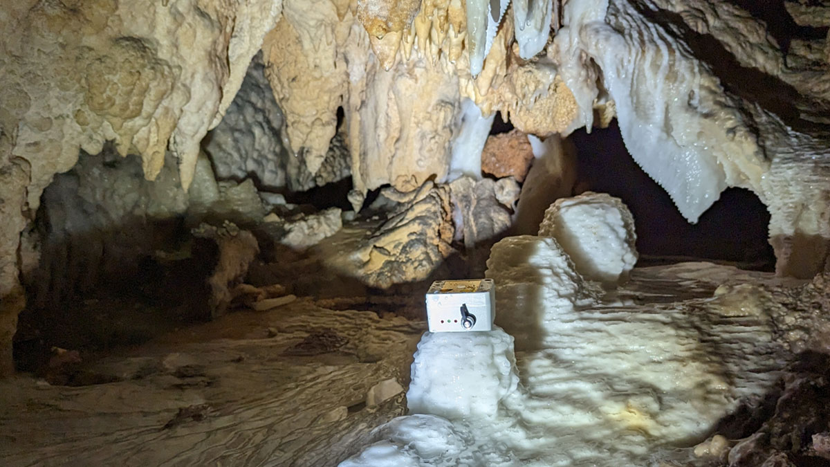
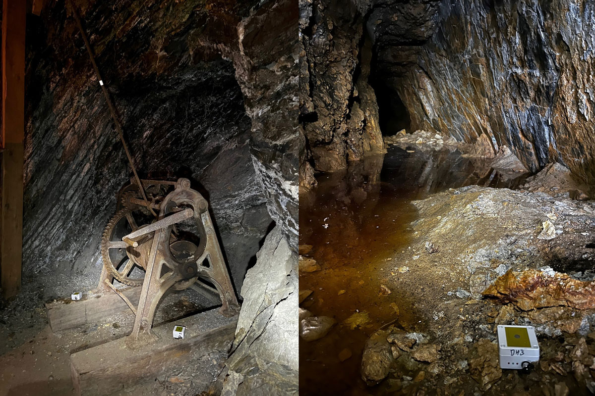
Our team has implemented an innovative approach to quantify rainfall recharge thresholds throughout Australia [Baker et al., 2024]. The approach involves directly detecting potential groundwater recharge using a network of automated hydrological loggers deployed as close to the water table as possible (so measurements are as representative of true recharge as possible) in underground tunnels, mines, and caves (Figure 1).
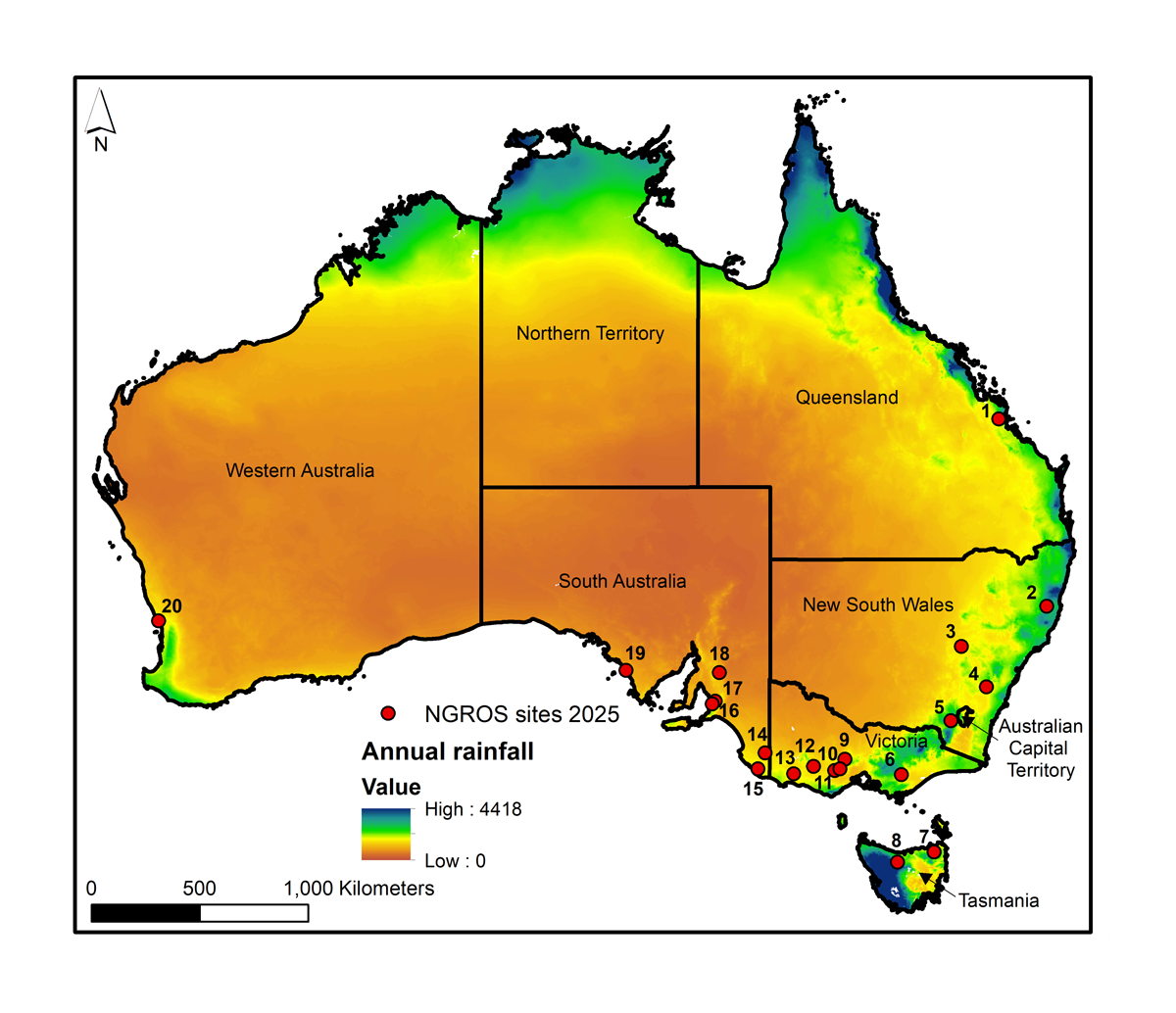
Since 2022, we have placed loggers at 20 sites, such as an abandoned train tunnel in Precambrian to Cambrian sandstone (at Old Sleep’s Hill Tunnel in South Australia; Figure 1, site 16), a heritage gold mine in Devonian metasedimentary rock (at Walhalla Mine in eastern Victoria; site 6), and a lava cave in Quaternary basalt (at Byaduk Lava Cave in western Victoria; site 13). These sensors make up Australia’s National Groundwater Recharge Observing System (NGROS), the first dedicated network for observing event-scale groundwater recharge across different geologic and surface environments, as well as across a wide range of Australian hydroclimates.
The hydrological loggers we use detect the impacts of falling water droplets that hit them, meaning they must be placed in open underground spaces, rather than buried in soil. They were originally designed to count drips falling from cave stalactites, but they count drips falling from the roof of any underground space just as well.
Sharp increases in drip rates allow us to identify the precise timing of recharge events.
In the time series datasets from replicate loggers at each site, sharp increases in drip rates allow us to identify the precise timing (and location, season, and climatic conditions) of recharge events—similar to how spikes in streamflow help identify flood episodes in river hydrographs. With this information, we can tie recharge to specific precipitation events, and by combining it with daily rainfall data, we can quantify rainfall recharge thresholds and their variability with geography and through time.
Confidently linking rainfall and recharge events also requires that water percolate from the surface toward the water table fast enough that the rainfall response is preserved. For this reason, loggers are placed where water flows predominantly—and rapidly—through features such as rock fractures rather than more slowly through tighter pore spaces. Data from NGROS therefore also shed light on recharge processes in fractured rock terrains, which have been relatively less researched than those in porous rocks and sediments.
We deliberately sited some NGROS sensors to be close to Australia’s new network of critical zone observatories to complement infrastructure that is recording stocks and flows of carbon, water, and mass from the plant canopy to the groundwater. We also chose cave sites where we plan to reconstruct records of past recharge by analyzing cave stalagmites. Our improved understanding of the climate conditions necessary for recharge to occur today will help us interpret stalagmite oxygen isotope compositions at these sites as a proxy for past periods of groundwater recharge and drought.
Heavy Rains Required
At NGROS sites where at least 1 year’s worth of data have been collected, we’ve observed that 10–20 millimeters of rainfall over 48 hours are typically needed to initiate recharge in fractured rock aquifers [Priestley et al., 2025].
We have seen a clear relationship across the sites between lower numbers of recharge events and higher rainfall thresholds.
Such rainfall events are infrequent in Australia. Between five and 18 occurred at each site in the first year the loggers were observing, with the fewest observed at Daylight Cave in eastern New South Wales (site 2) and the most at Capricorn Caves in central Queensland (site 1). These rainfall recharge events generally occurred when specific weather conditions manifested, such as the co-occurrence of cyclones or fronts with thunderstorms.
Regardless of the frequency of recharge events, we have seen a clear relationship across the sites between lower numbers of recharge events and higher rainfall thresholds. This relationship also holds despite differences in soil, vegetation, geology, and depth to the loggers, suggesting that climate is a major control on rainfall thresholds.
Most of the rainfall recharge events (86%) occurred in wetter seasons, and during these times, rainfall recharge thresholds were lower than in drier seasons: The median wet season rainfall recharge threshold was 19.5 millimeters in 48 hours, compared with 30.4 millimeters per 48 hours in the dry season [Priestley et al., 2025].
The seasonal control on recharge is likely related to the greater amount of rainfall required to saturate soils during dry season events, although this control may be modulated by site‐specific factors such as soil conditions, unsaturated zone thickness, and vegetation. For example, sites vegetated with native woodland might be expected to have a greater unsaturated zone water demand in hot summer conditions and therefore to require more rainfall to generate recharge than more sparsely vegetated sites [Baker et al., 2024]. We will investigate the influence of these factors further as we collect longer time series of data.
Our results have also produced some surprising findings. Although we expected that antecedent weather conditions would influence the amount of rainfall needed for recharge to occur, we have not yet seen a clear relationship between preceding rainfall amounts or the time since the last recharge event and observed rainfall recharge thresholds. Longer time series of data should help to clarify the role of antecedent conditions as well.
Guiding Groundwater Management
Findings from NGROS have important implications for water management in Australia. Government groundwater management strategies, such as in the states of New South Wales and South Australia, where groundwater is the largest source of freshwater, rely on scientific data to support sustainable extraction and to protect groundwater-dependent ecosystems.
Our observations provide useful guidance for regulators setting extraction limits in the near term; they’re also useful to groundwater managers planning for changing future demands.
Our observations showing that only a handful of recharge events occur annually and that recharge requires a relatively high rainfall amount can, for example, provide useful guidance for regulators setting extraction limits in the near term. They’re also useful to groundwater managers planning for changing future demands resulting from changes in population, growth in agriculture and in mining industries supporting the green energy transition, and climate change.
Climate change is predicted to cause greater climatic variability across Australia, parts of which are already experiencing both wet and dry extremes. However, it is not yet clear to what extent changes in the climatic conditions that affect rainfall recharge thresholds will influence soil infiltration and overall groundwater recharge. The NGROS network is designed to investigate this question.
As a growing number of towns and even large cities (e.g., Perth, Western Australia [Broderick and McFarlane, 2022]) are forced to consider alternatives to shrinking groundwater resources, detailed information about regional and local recharge could help improve decisionmaking and give water managers more time to consider options.
NGROS findings also highlight that models used to inform groundwater management should factor in how recharge relates not only to rainfall amounts but also to the season and manner in which the rain is delivered (e.g., in long-duration, high-magnitude events versus intense bursts or prolonged sprinkles). This treatment conflicts with current practice, which typically quantifies recharge as a percentage, or some function, of annual rainfall. By instead considering the links between rainfall patterns and recharge, we can better identify how climate-induced changes in rainfall may impact future recharge.
Expanding the Network
NGROS data are already providing a more detailed understanding of rainfall recharge thresholds in Australia, helping refine recharge rate estimates by showing which rainfall event characteristics lead to recharge. Longer NGROS network time series, combined with other data such as groundwater level observations, will further help quantify recharge processes and reveal variability and trends over time and across the continent.
The concept of an underground groundwater recharge observing network could be applied more widely.
Beyond the 20 sites currently instrumented, the concept of an underground groundwater recharge observing network could be applied more widely, and we are continuously looking to expand the network within Australia and beyond.
Most recently, we installed loggers in sinkholes (vertical dissolution caves) on the Eyre Peninsula in South Australia, an arid region where groundwater levels have been falling. We have also commenced collaborations with colleagues in Africa, Europe, and North America, sharing our experience and know-how in setting up logger networks.
If groundwater observing networks are expanded to other parts of the world, researchers could compare recharge thresholds and processes across a wider range of climates, weather patterns, geologies, and environments to gain a more comprehensive view of when and how precipitation leads to recharge. Such knowledge would support sustainable management of vital groundwater resources not only in Australia but around the world.
Acknowledgments
Maria de Lourdes Melo Zurita (University of New South Wales, Sydney) also contributed to the underlying research project and provided feedback for this article.
References
Baker, A., et al. (2024), An underground drip water monitoring network to characterize rainfall recharge of groundwater at different geologies, environments, and climates across Australia, Geosci. Instrum. Methods Data Syst., 13(1), 117–129, https://doi.org/10.5194/gi-13-117-2024.
Broderick, K., and D. McFarlane (2022), Water resources planning in a drying climate in the south-west of Western Australia, Australas. J. Water Resour., 26(1), 72–83, https://doi.org/10.1080/13241583.2022.2078470.
Priestley, S. C., et al. (2025), Groundwater recharge of fractured rock aquifers in SE Australia is episodic and controlled by season and rainfall amount, Geophys. Res. Lett., 52(5), e2024GL113503, https://doi.org/10.1029/2024GL113503.
Author Information
Stacey Priestley ([email protected]), Commonwealth Scientific and Industrial Research Organisation, Adelaide, SA, Australia; Andy Baker ([email protected]), University of New South Wales, Sydney, Australia; Margaret Shanafield, Flinders University, SA, Adelaide, Australia; Wendy Timms, Deakin University, Geelong Waurn Ponds, Vic, Australia; and Martin Andersen, University of New South Wales, Sydney, Australia