The 2025 Palisades and Eaton Fires torched scrub-lined slopes of the San Gabriel and Santa Monica Mountains, as well as buildings, streets, cars, and infrastructure.
Before the flames were even contained, scientists from throughout the Los Angeles (LA) metro area turned to the skies, their labs, and their communities to study the extent of the damage. Their work is informing residents and other researchers about how hazards from the fires have shifted in the weeks and months after containment, and how they could change in the years to come.
Scientists are learning how the fires, which burned along the urban-wildland interface, were distinct from strictly urban or rural fires in terms of chemistry, topographic changes, and follow-on hazards.
During Containment
While firefighters were still battling flames on the ground, an airborne surveyor team took stock of the damage, mapping the scope and extent of the fires and assessing which areas needed immediate remediation.
On 11 January 2025, NASA’s Airborne Visible/Infrared Imaging Spectrometer 3 (AVIRIS-3) flew over Los Angeles County mounted on a B200 research plane. The instrument provided some of the first aerial data assessing the scope of the Palisades Fire while it was still smoldering. It flew over the Eaton Fire soon thereafter.
“We immediately looked for methane or natural gas,” said Robert Green, principal investigator for AVIRIS-3 at NASA’s Jet Propulsion Laboratory in Pasadena. Natural gas leaks can pose health and safety risks to first responders. The instrument did not detect any abnormalities.
“But then we realized we had this dataset and could do advanced spectroscopic mapping of the burn severity and the burn products—the char and the ash,” Green said.
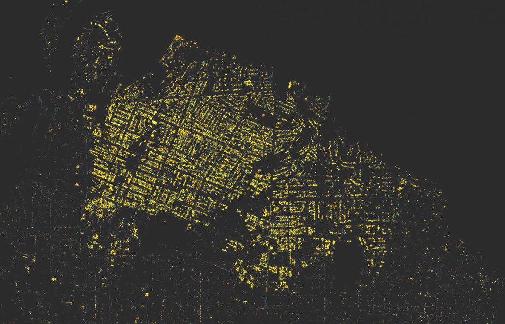
AVIRIS-3 data showed that the Eaton Fire burned more wildland area than urban area, largely because fire managers focused prevention efforts on areas in which people were endangered, Green explained. Initial maps of burn severity, which were provided to first responders, showed that within the burn area, nearly all structures suffered moderate to severe surface-level burns. Very few patches of urban vegetation survived.
“We’ve never had an urban fire like this to collect datasets.”
The instrument completed subsequent surveys of the Eaton and Palisades burn scars in late May.
“We’ve never had an urban fire like this to collect datasets,” Green said. “There’s a whole bunch of new spectroscopic compounds established by burning these [urban] materials, which are different than those you would find in a natural environment.” These surveys will help scientists track combustion products and how long they persist in the soil.
Lead Laden
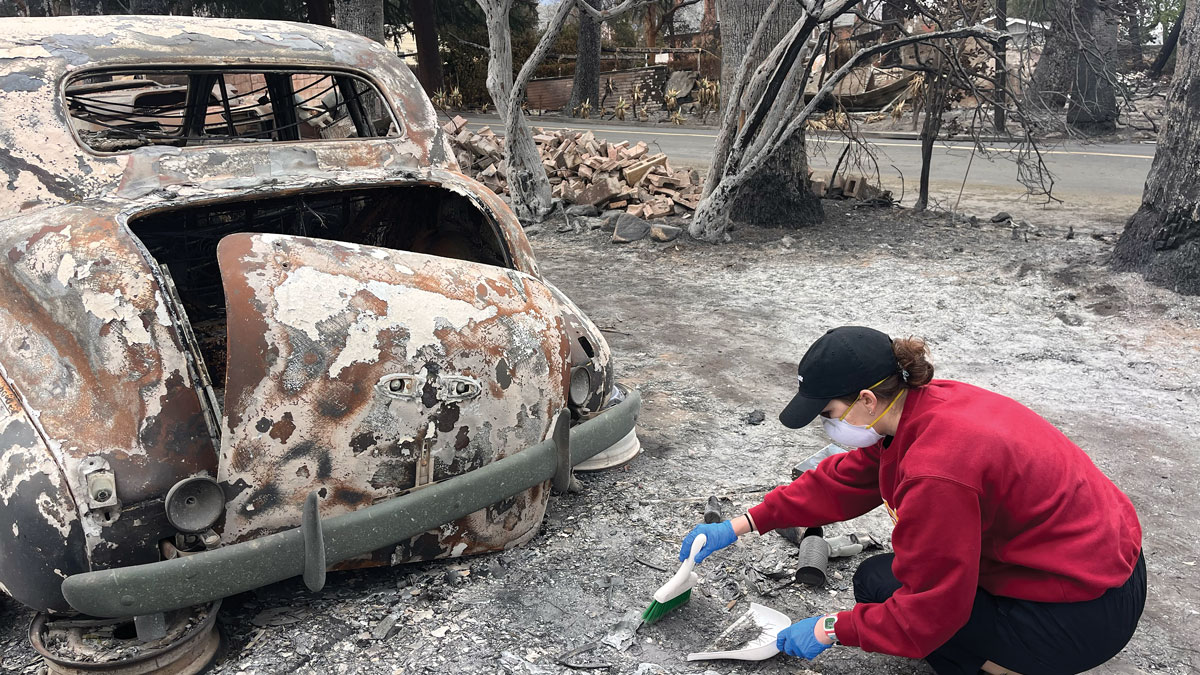
After the fires were contained, many local scientists mobilized with the tools and people they had at hand—themselves, their students, and even their children—to collect ash, dust, and soil samples. They and fellow residents wanted to know what chemicals enter the environment when wildland-urban fires burn, how bioavailable they are, and how long they present a danger.
“We were scrambling to get ready for the rain. A lot of these data, from a scientific point of view, are perishable.”
Many scientists homed in on lead contamination. Of the more than 7,000 homes and structures that burned, most were built before 1975, when lead-based paint was commonly used. Lead that enters the body is easily absorbed into blood and can cause significant neurological harm, especially in children. It is particularly dangerous when inhaled or ingested as fine dust, and fire ash and dust are key exposure routes. Residents wondered when it would be safe for children and pets to play outside and whether it was safe to eat vegetables from their gardens.
Time was of the essence to collect samples, explained Joshua West of the University of Southern California (USC) in LA, not only because of the potential health impact but also because imminent wind and rain threatened to redistribute or wash away the fires’ by-products.
“We were scrambling to get ready for the rain,” West said. “A lot of these data, from a scientific point of view, are perishable.”
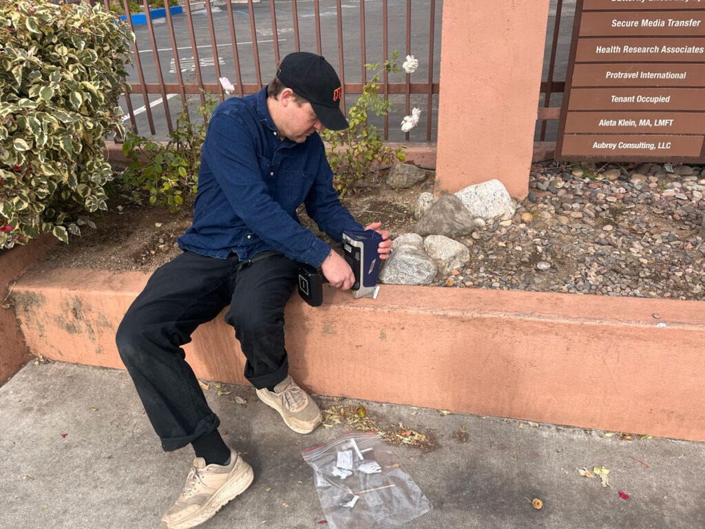
A team of USC scientists, including West and Earth scientist Seth John, tested dust and ash along the edges of the Altadena burn scar in late January. Over several weekends, the scientists used handheld instruments to measure the lead concentrations in dust that had accumulated on streets and playgrounds. They also collected samples for further analysis in the lab.
EPA’s thresholds for levels of lead in residential soil and playgrounds are 200 parts per million generally and 100 parts per million for sites with multiple sources of exposure. The researchers found that a few roadside spots exceeded those thresholds but no playground samples did.
The team also found a strong correlation between lead levels and proximity to burned structures but not to wildland.
“It seems very clear that there is higher lead in the areas with destroyed structures,” John said.
Wildland ash had low concentrations of lead.
A team from the California Institute of Technology (Caltech) in Pasadena similarly found that ash closest to burned structures contained higher concentrations of lead. The Caltech analysis could differentiate wildland and urban ash and found that wildland ash had low concentrations of lead.
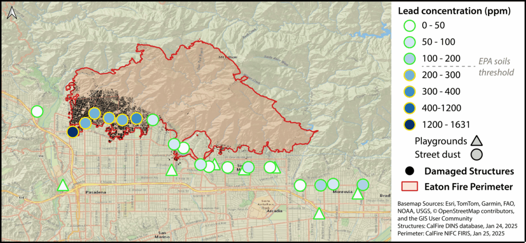
“No amount of lead is safe,” John cautioned. “That said, these levels are elevated, but I wouldn’t say they’re elevated to extremely toxic levels.” The researchers found similar trends in dust near the Palisades burn scar.
The USC team returned to the same locations every few weeks to collect more roadside dust samples. As of June, lead concentrations were slowly going down but were still elevated in most of the sample locations in Altadena, John said.
Another Caltech team measured lead concentrations in dust—a fine mix of ash particles, soot, and aerosols—that accumulated on indoor and outdoor surfaces. Many dust samples had lead concentrations exceeding EPA limits. Although simple cleaning with water was often enough to remove that lead, cleanup efforts can disturb new dust and prolong exposure risk.
A survey of garden soil samples found that about 35% had lead concentrations exceeding California’s recommended lead limit, but only about 7% exceeded the EPA’s limit (which is higher). They also found that soil lead levels could vary significantly within a single residential yard and that finer soil particles (smaller than 250 micrometers) had higher lead levels than a mixed soil sample.
The Risks of Rain
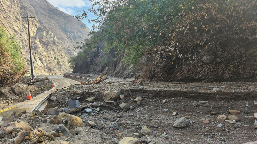
As cleanup efforts began in earnest and residents started returning, they were aware of the lingering hazard of debris flows and landslides from the charred slopes of the San Gabriel and Santa Monica Mountains.
The mountains are steep, and gravity slowly moves soil, rocks, and sand downhill, explained Emily Geyman, a graduate student researching climate and surface processes at Caltech. Low brush and scrappy mountainside shrubs typically interrupt that flow and accumulate that debris before it reaches foothill neighborhoods.
“Once you incinerate that [vegetation], those sand grains that are perched at this angle that should be unstable come cascading down,” Geyman said.
What’s more, fires can mobilize contaminants and change soil chemistry so that it repels, rather than absorbs, water and loosens soil so it’s more likely to fall downslope, explained West, who also studied the potential for debris flows in the San Gabriels. Gravity funnels sand and debris into natural channels where it builds up, compounding runoff and erosion risks.
“These are probably some of the first fires in which we have the post-fire, pre-rain topography at really high resolution.”
Studies of past wildfires in the San Gabriels have shown that between 20 and 50 years’ worth of soil erosion happens during the first 2 years following a wildfire. Sudden erosion can damage infrastructure, fill debris basins, and strip ecosystems of critical soil nutrients and structure.
Between 25 January and 24 March, Geyman and other Caltech researchers conducted 10 uncrewed aerial vehicle (UAV) lidar surveys above the Eaton Fire burn scar. They surveyed mountain catchments and debris basins—artificially dug repositories to contain flows—before and after every major rain since the fires.
“These are probably some of the first fires in which we have the post-fire, pre-rain topography at really high resolution,” West said. “Being able to capture that time sequence going forward is one of our big goals.”
A significant rainfall on 13 February triggered debris flows in almost every mountain catchment in the Eaton Fire burn area, Geyman said. Using pre-rain and post-rain lidar scans, the researchers estimated that 680,000 cubic meters of material cascaded downhill, “equivalent in volume to about 270 Olympic-sized swimming pools,” Geyman added.
Debris basins captured most of the flow before it affected residential neighborhoods. “The debris basin infrastructure largely did its job,” Geyman said. Debris flows have not caused any additional loss of life.
Similar UAV lidar work by geomorphologist Seulgi Moon and her colleagues at the University of California, Los Angeles (UCLA), resulted in digital elevation maps of debris channels in Topanga Canyon, an area in the Santa Monica Mountains affected by the Palisades Fire, before and after the February rains. They continue to assess debris flow hazards in the canyon.
The Paths Ahead
UAV surveys continue, and scientists are monitoring debris channels to assess the ongoing risk of landslides and debris flows.
“We plan to continue the surveys before and after each major rain event [through] winter 2026 or until…the loose sediment released from the hillslopes during the fire is cleared out,” Geyman said.
Moon and her colleagues plan to install a geophone and five debris flow monitoring stations in the canyon to monitor ongoing hazards in the area for 2 years. Any ground motion, whether from a skittering animal or an imminent debris flow, will create vibrations. A geophone converts them into a measurable voltage.
“We want to make the connection between how much rain is coming and how much sediment will come downstream,” she said.
Data from both groups will help scientists understand which debris flow mechanisms are most likely, track the volume of material at which flows become imminent, and help inform hazard maps to aid emergency response.
After the initial rush of dust, ash, and soil collection, many research groups shifted to community-led sampling efforts. John and West, for example, set up a free community sampling program for lead in soils and received more than 1,000 samples by mid-May. Some groups are reaching out to residents who want their soil tested or who want to contribute to scientific efforts. Other teams at UCLA and Loyola Marymount University created similar lead soil testing programs for communities.
The AVIRIS-3 team is working with laboratory scientists to match the aerial spectral signatures to those of burn products in ash samples. Green said that every burn compound the team catalogs will help efforts to protect first responders during future urban fires and inform future instruments that could identify when burnable material builds up in fire-prone areas.
Additional flyovers may happen when AVIRIS-3 flies to or from its home base in LA, Green said. Those data could be used to track how environmental damage such as toxic ash contamination and soil erosion change over time.
“That might inform our understanding [of] how this urban-rural interface is changing and what the recovery looks like,” Green said.
—Kimberly M. S. Cartier (@astrokimcartier.bsky.social), Staff Writer