
In American Samoa, the sea is rising 4 times faster than the global average. And an ongoing project has shown that land subsidence is to blame: The crust is relaxing after an earthquake and tsunami in 2009, compounding the effects of climate change.
“The water is getting higher because the volume of water is getting bigger, but also because the land is getting lower,” explained Carla Baizeau, a graduate student in physical oceanography at the University of Hawai‘i at Mānoa and a member of the project.
That’s a big problem for the U.S. territory. Saltwater intrusion into aquifers endangers the water supply and strains the islands’ ecosystems. Narrowing coastlines support most of the islands’ infrastructure, including electricity, telecommunications, and sewerage.
“As an island located far from the mainland USA, our airport and seaport infrastructure are key to our people’s survival.”
“All our airports and seaports are located along the coast and are most susceptible to the impacts of sea level rise,” said Natalia Palamo, chief engineer at the Department of Port Administration in American Samoa, who was not involved with this research. “As an island located far from the mainland USA, our airport and seaport infrastructure are key to our people’s survival.”
Rising Seas and Sinking Land
Global sea level is currently rising about 4 millimeters (0.16 inch) per year. Calculations of future changes include some amount of land motion to estimate effects on coastal communities—an average rate applied uniformly around the globe. That rate describes local motion quite well for most of the world, but it can be inaccurate in places where land moves quickly.
That’s the case in American Samoa and nearby island nations, where a pair of strong earthquakes and tsunamis struck in 2009. As the crust rebounds, the surface is sinking.
Researchers sought to demonstrate how that land subsidence changes American Samoa’s future under different greenhouse gas emissions scenarios. They gathered decades of tide gauge data from instruments deployed on the islands of Tutuila and Aunuʻu, the Manuʻa Islands (Ofu, Olosega, and Ta‘ū), and Rose Atoll.
Those data revealed that the islands experience about 16 millimeters per year of sea level rise.


They then gathered measurements of land subsidence using GPS, Global Navigation Satellite System (GNSS), lidar, and geodesy data to understand how quickly land is sinking.
Prior surveys had calculated subsidence rates for Tutuila and its close neighbor Aunuʻu, but satellite imagery of the Manuʻa Islands was unavailable, explained Kelley Anderson Tagarino, the University of Hawai‘i Sea Grant extension agent based at American Samoa Community College in Mapusaga. New tide gauges and GPS ground control points have since been installed in the Ofu, Ta‘ū, and Aunuʻu harbors and in eastern Tutuila’s ʻAuʻasi harbor.
“We can start getting real data there instead of just assumed rates of sea level or subsidence that are all derived from Tutuila-based benchmarks,” Tagarino said. “This has really been helpful for folks to understand that our subsidence is variable,” even across Tutuila.
The team found that 84% of the sea level rise experienced since the tsunami is due to sinking land. Because of that, high-emissions climate change projections underestimate by 50% the 2030 sea level rise. The projections also underestimate by 45% the area that will be affected by flooding. Baizeau presented these results at AGU’s Ocean Sciences Meeting 2024.


Planning for the Future
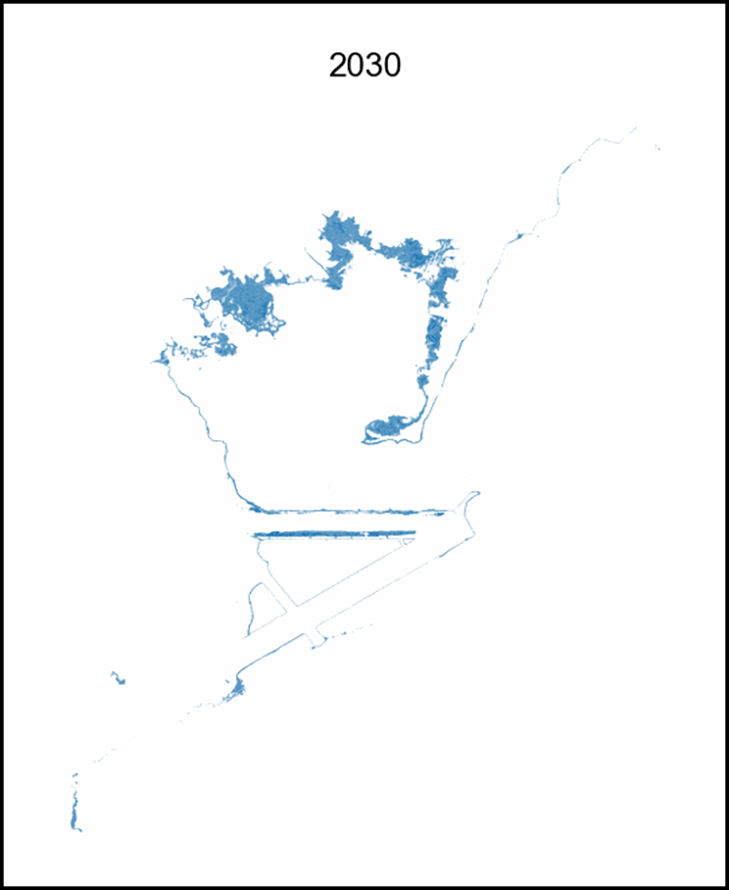
To help residents learn more about the risk of flooding and how it could affect local infrastructure, the researchers and community leaders cocreated an interactive sea level rise viewer for American Samoa. The tool allows users to see an area’s future flood risk under different emissions scenarios and also explore vertical land motion. Users can zoom in far enough to see individual houses, land holdings, agricultural areas, wetlands, and infrastructure, a critical feature for a territory that usually fits within a few pixels on lower-resolution maps.
“The community can plan within their family, extended family, village, or even larger, like a county or even district…however they see fit,” Tagarino said.
Baizeau and Tagarino demonstrated the interactive tool to village mayors, or pulenu’u, and other Samoan decisionmakers in September 2023. Tagarino said it was the first time many of them had realized the extent to which their lands and homes were in danger from the encroaching ocean.
“The tool has been very helpful in illustrating the extensive impacts of sea level rise on our islands in a quick snapshot.”
“The tool has been very helpful in illustrating the extensive impacts of sea level rise on our islands in a quick snapshot,” Palamo said. “To date, we have used and cited the tool in about four of our grant applications for coastal infrastructure improvements,” such as shoreline protection and wharf reconstruction.
Baizeau said the researchers plan to expand the tool to include Swains Island, the territory’s second atoll, and to keep improving upon the islands’ digital elevation maps to gain a more complete picture of subsidence.
“I’ve had some students tell me they’ve shared it with their families,” Tagarino said. “And the general reaction is fear, and then wanting to know what resources are available to help people adapt.”
—Kimberly M. S. Cartier (@AstroKimCartier), Staff Writer