
Quantum mechanics rules the atomic world, challenging our intuitions based on Newton’s classical mechanics. And yet atoms share at least one commonality with Newton’s apple and with you and me: They experience gravity and fall in the same way.
Of course, observing free-falling atoms requires extremely sophisticated experimental devices, which became available only in the 1990s with the advent of laser cooling. Heat represents the extent to which atoms move, so cooling atoms eases their manipulation, allowing scientists to measure their free fall and to quantify and study the effects of gravity with extraordinary precision. Creating samples of ultracold atoms involves slowing the atoms using the momentum of photons in specialized laser beams.
Today novel developments in methods using ultracold atoms and laser technologies open enhanced prospects for applying quantum physics in both satellite and terrestrial geodesy—the science of measuring the shape, rotation, and gravity of Earth—and for improving measurement reference systems. Such methods have great potential for more accurately monitoring how the Earth system is responding to natural and human-induced forcing, from the planet’s solid surface shifting in response to tectonic and magmatic movements to sea level rising in response to melting glaciers.
Taking Earth’s Measure
Earth’s shape is always changing, even if the changes are mostly imperceptible to us humans. In the subsurface, large convection currents and plate tectonics influence each other, shifting huge masses of rock around and causing earthquakes and volcanic eruptions. On the surface, the ocean, atmosphere, glaciers, rivers, and aquifers never rest either—nor do we as we excavate rock, extract groundwater and oil, and generally move mass around. All these movements subtly affect not only the planet’s shape but also its rotation and its gravitational field.
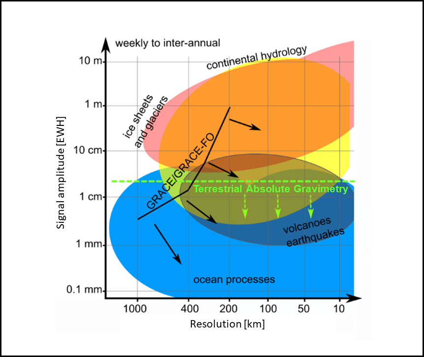
Geodetic methods allow us to measure minute quantities that tell scientists a lot about Earth’s size, shape, and makeup. As such, geodesy is essential to all branches of geophysics: tectonics, seismology, volcanology, oceanography, hydrology, glaciology, geomagnetism, climatology, meteorology, planetology, and even metrology, physics, and astronomy. Measuring these changes sheds light on many important Earth processes, such as mass loss from polar ice sheets, yet making these measurements accurately remains a challenging task (Figure 1).
Determining the elevation of an ice sheet’s surface, to gauge whether it might have lost or gained mass, is often done using laser altimetry—that is, by observing the travel time of a laser beam emitted from a plane or a satellite and reflected off the ice surface back up to the observer. It’s a powerful technique, but the laser does not necessarily distinguish between light, fresh snow and dense, old ice, introducing uncertainty into the measurement and into our understanding of the ice sheet’s change.
Beyond this ambiguity, what happens if Earth’s crust beneath the ice cap is deforming and influencing the elevation of the ice surface? Moreover, the altimeter’s observation is relative: The elevation of the ice sheet surface is measured with respect to the position of the observing aircraft or satellite, which itself must be determined in comparison to a reference height datum (typically sea level). This feat requires measuring quantities that are exceedingly small compared with the size of Earth. If you drew a circle representing Earth on a standard piece of printer paper, even the 20-kilometer difference in height between Mount Everest’s peak and the bottom of abyssal oceanic trenches—would be thinner than the thickness of your pencil line!
Changes in Earth’s rotation, deformations, and gravity must be measured with precisions that are 10 orders of magnitude shorter than the length of the day, smaller than Earth’s diameter, and weaker than the gravity itself, respectively.
Meanwhile, measuring variation in Earth’s rotation means determining its instantaneous orientation relative to fixed stars to within a fraction of a thousandth of an arc second—the amount Earth rotates in a few micro arc seconds. Assessing velocities and deformations of the tectonic plates requires determining positions at the millimeter scale. And detecting groundwater mass changes requires measuring the associated gravitational effect of a 1-centimeter-thick layer of water (i.e., equivalent water height, or EWH) spread over a 160,000-square-kilometer area. In other words, changes in Earth’s rotation, deformations, and gravity must be measured with precisions that are 10 orders of magnitude shorter than the length of the day, smaller than Earth’s diameter, and weaker than the gravity itself, respectively.
The Challenges of Attraction
Performing gravity measurements and analyses remains especially demanding. For land-based measurements, gravimeters are generally cumbersome, expensive, tricky to use and, in the case of the most precise superconducting instruments, require a high-wattage (1,500-watt) continuous power supply. In addition, most gravimeters, including superconducting instruments, offer only relative measurements—that is, they inform us about spatial and temporal variations in gravitational attraction, but they drift with time and do not provide the absolute value of gravitational acceleration (about 9.8 meters per second squared). Absolute gravimeters do, but these instruments are rare, expensive (costing roughly $500,000 apiece), and heavy. And as most are mechanical, wear and tear prevents their use for continuous measurements.
Moreover, terrestrial gravimeters are mostly sensitive to the mass distribution nearby, in a radius of a few hundred meters from the instrument. This sensitivity and scale allow observation of rapid and small-scale changes, such as from flash floods, in small watersheds or glaciers, and in volcanic systems, but they complicate data gathering over larger areas.
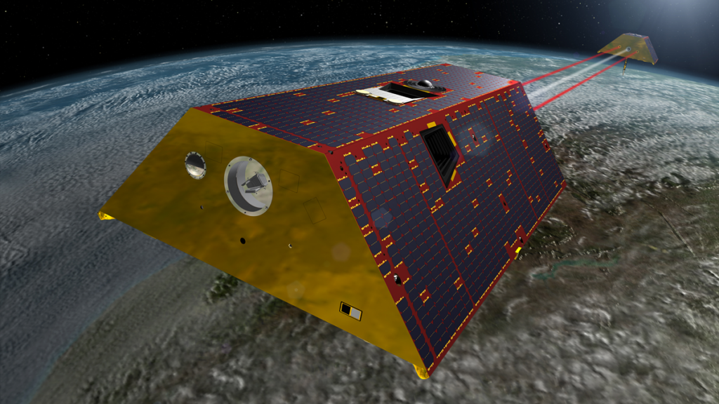
On the other hand, space-based gravimetry, realized in the Gravity Recovery and Climate Experiment mission and its follow-on mission, GRACE-FO, is blind to structures smaller than a few hundred kilometers. However, it offers unique information of homogeneous quality about mass anomalies over larger areas within Earth or at its surface. These missions can detect and monitor a mass change equivalent to a 1-centimeter EWH spread over a 400- × 400-kilometer area, with a temporal resolution of 10 days.
To monitor change from important Earth processes—from flooding and volcanism to glacier melting and groundwater movement—reliably and across scales, we need gravitational data with better spatiotemporal resolution and higher accuracy than are currently available (Figure 1). We also need highly stable and accurate reference systems to provide the fundamental backbone required to monitor sea level changes and tectonic and human-induced deformation. The needed improvements can be achieved only by using innovative quantum technologies.
The past few years have seen new efforts to develop such technologies for many uses. In 2018, for example, the European Commission began a long-term research and innovation initiative called Quantum Flagship. For geodetic applications, efforts are being coordinated and supported largely through the Novel Sensors and Quantum Technology for Geodesy (QuGe) program, a worldwide initiative organized under the umbrella of the International Association of Geodesy and launched in 2019. QuGe fosters synergies in technology development, space mission requirements, and geodetic and geophysical modeling by organizing workshops and conference sessions and by otherwise providing a platform where experts from different fields can collaborate.
A Quantum Upgrade for Gravity Sensing
Quantum gravimetry will benefit a comprehensive set of applications, from fast, localized gravity surveys and exploration to observing regional and global Earth system processes with high spatial and temporal resolution.
QuGe emphasizes three pillars of development. The first focuses on investigations of ultracold-atom technologies for gravimetry on the ground and in space. Quantum gravimetry will benefit a comprehensive set of applications, from fast, localized gravity surveys and exploration to observing regional and global Earth system processes with high spatial and temporal resolution.
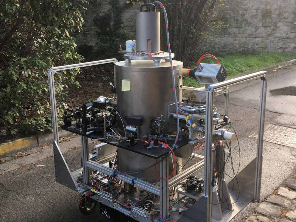
On Earth, the ideal instrument is an absolute, rather than relative, gravimeter capable of taking continuous measurements. This is not possible with a classical mechanical absolute gravimeter, in which a test mass is repeatedly dropped and lifted. In atomic instruments, there are no mobile parts or mechanical wear; instead, lasers control falling rubidium atoms. Recent achievements should enable production of such instruments on a larger scale, allowing scientists to establish dense networks of absolute gravimetric instruments to monitor, for example, aquifer and volcanic systems.
Today achieving dense coverage with gravimetric surveys, with measurements made at perhaps dozens of points, involves huge efforts, and sampling rates—with measurements taken typically once every month, year, or more—are still poor. Moreover, errors related to instrument calibration and drift remain problematic. Alternatively, a fixed instrument provides a measurement every second but at only a single location. The ability to continuously measure gravity at multiple locations, without the difficulties of drifting instruments, will allow much less ambiguous interpretations of gravity changes and related geophysical phenomena.
Measuring Earth’s gravity field from space requires precisely monitoring the changing distance between paired orbiting satellites—as in the GRACE-FO mission—which accelerate and decelerate slightly as they are tugged more or less by the gravitational pull exerted by different masses on Earth. However, the satellites can also speed up and slow down because of forces other than changes in Earth’s gravity field, including aerodynamic drag in the thin upper atmosphere. Currently, these other forces acting on the satellites are measured using electrostatic, suspended-mass accelerometers, which also tend to exhibit gradual, low-frequency drifts that hamper their accuracy.
The performance of these traditional accelerometers is thus challenged by quantum sensors, which have already demonstrated improved long-term stability and lower noise levels on the ground. In addition, hybrid systems combining the benefits of quantum accelerometers with electrostatic accelerometers, which still provide higher measurement rates, could cover a wider range of slower and faster accelerations and could greatly support navigation and inertial sensing on the ground and in space. Quantum accelerometers will also serve as a basis for developing the next generation of gravity-monitoring missions, such as the follow-on to the Gravity field and steady-state Ocean Circulation Explorer (GOCE) mission, which will measure gravity differences in 3D and allow higher-resolution mapping of Earth’s static gravity field.
Wide-Ranging Improvement
The second pillar of QuGe focuses on improving technology for laser interferometric ranging between spacecraft to achieve nanometer-scale accuracy, which will become the standard for future geodetic gravity-sensing missions. This method involves comparing the difference in phase between two laser beams: a reference beam and a test beam received back from the second satellite. Such optical measurements are much more precise than similar measurements using microwave ranging or mechanical devices, allowing intersatellite distances to be observed with an accuracy of tens of nanometers or better compared with micrometer accuracies achieved with microwaves.
High-precision laser ranging was successfully tested in 2017 during the Laser Interferometer Space Antenna (LISA) Pathfinder mission, in which the main goal was to hold the spacecraft as motionless as possible to test technology for use in future missions that will seek to detect gravitational waves with a space-based observatory. It has also been applied successfully in the GRACE-FO mission, demonstrating the superior performance for intersatellite tracking of laser interferometry over traditional microwave-based ranging methods used in the original GRACE mission.
Although extremely useful, recent satellite gravity missions give only rather rough pictures of global mass variations. Enhanced monitoring of intersatellite distances should improve the ability to resolve 1-centimeter EWH to about 200 kilometers or finer, instead of the 400 kilometers presently. This improvement will allow better separation of overlapping effects, such as continental versus oceanic mass contributions along coastlines, changes in neighboring subsurface aquifers, and variations in glaciers and nearby groundwater tables.
Even more refined concepts, like intersatellite tracking using laser interferometry for multiple satellite pairs or among a swarm of satellites, might be realized as well within the coming years. Using more satellites in next-generation geodetic missions would yield data with higher temporal and spatial resolution and accuracy—and hence with greater ability to distinguish smaller-scale processes—than are available with current two-satellite configurations.
Measuring Height with Optical Clocks
QuGe’s third pillar of development focuses on applying general relativity and optical clocks to improve measurement reference systems. Einstein told us that gravity distorts space and time. In particular, a clock closer to a mass—or, say, at a lower elevation on Earth’s surface, closer to the planet’s center of mass—runs slower than one farther away. Hence, comparing the ticking rates of accurate clocks placed at different locations on Earth informs us about height differences, a technique called chronometric leveling. This technique has been achieved by comparing outputs from highly precise optical clocks connected by optical links over distances on the order of 1,000 kilometers.
Today systems for measuring height are referenced to mean sea level in some way, for example, through tide gauges. However, sea level is not stable enough to be used as a reference.
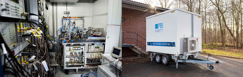
Optical clocks keep time by measuring the high frequency of a laser light that is kept locked to the transition frequency between two given energy levels of electrons in ultracold (laser-cooled) atoms or ions. These clocks have demonstrated at least a 100-fold improvement in accuracy over the usual atomic clocks, which measure lower-frequency microwave transitions. With a global network of such optical clocks, if we can remotely compare the clocks’ frequencies with the same accuracy, we could realize a global height reference with 1-centimeter consistency. One can even imagine the reference clocks being placed in a high satellite orbit, far from the noisy Earth environment, to serve as a stable reference for terrestrial height systems and improve measurement accuracy.
In addition to chronometric leveling, such clocks will improve the accuracy of the International Atomic Time standard—the basis for the Coordinated Universal Time used for civil timekeeping—and will have many other impacts on science and technology. For example, global navigation satellite systems could provide better navigation by using more predictable clocks on satellites, which would have the added advantage of requiring less input from the ground operators controlling the satellite orbits. Space navigation could rely on one-way range measurements instead of on more time-consuming two-way ranging if a spacecraft’s clock were highly accurate. And radio astronomers could make use of more stable frequency references for easier processing and better results in very long baseline interferometry experiments. More fundamental applications are also envisioned for optical clocks, such as detecting gravitational waves, testing the constancy of the fundamental constants of physics, and even redefining the second.
The Best Tools for the Job
The future of high-precision geodesy lies in the development and application of novel technologies based on quantum mechanics and relativity.
Our knowledge of Earth’s shape and gravity and the subtle shifts they undergo in response to numerous natural and human-induced processes has grown immensely as geodetic methods and tools have matured. But with current technologies, the clarity and confidence with which we can discern these changes remain limited. Such limitations, namely, insufficient accuracy and resolution in time and space, will become increasingly important as we look to better understand and predict the consequences of accelerating—or even perhaps previously unrecognized—changes occurring as the planet responds to warming temperatures and other anthropogenic influences.
The future of high-precision geodesy lies in the development and application of novel technologies based on quantum mechanics and relativity. QuGe is working to ensure that the Earth and planetary sciences benefit from the vast potential of these technologies. In particular, ultracold-atom accelerometry, high-precision laser ranging between satellites, and relativistic geodesy with optical clocks are very promising approaches that will overcome problems of classical gravimetric Earth observations. With such advances, we will have the best tools available not only to understand vital geophysical processes but also to better navigate on Earth and in space and to discern the fundamental physics that underlie our world.
Author Information
Michel Van Camp ([email protected]), Royal Observatory of Belgium, Brussels; F. Pereira dos Santos, Laboratoire National de Métrologie et d’Essais–Système de Références Temps-Espace, Observatoire de Paris, Université Paris Sciences et Lettres, Centre National de la Recherche Scientifique, Sorbonne Université, France; Michael Murböck, Technische Universität Berlin, Germany; Gérard Petit, Bureau International des Poids et Mesures, Paris; and Jürgen Müller, Leibniz University Hannover, Germany