Imagine spending the winter camping near the North Pole, drifting on a raft of sea ice—temperatures below −30°C, five months of almost total darkness, and roaring sounds of crushing ice nearby (but you don’t know exactly where).
Germany and Norway’s first such venture in more than 100 years shows that scientifically successful mobile ice drift stations can be established in the Arctic.
On 30 August 2014, our two-man crew prepared to do just that. For the next 11.5 months, the sea ice and a hovercraft would be their home. Our goal was to obtain ocean sediments for studies of the Mesozoic and Cenozoic history of Arctic Ocean from 252 million years ago until the present time.
The venture is the product of cooperation between Norway and Germany, under the direction of the Nansen Environmental and Remote Sensing Center, located in Bergen, Norway. Our project, the Fram-2014/15—these nations’ first ice drift in the central Arctic Ocean in more than 100 years—shows that scientifically successful mobile ice drift stations can be established in the Arctic at low cost.

A Journey into the Unknown
Our scientists started from the Makarov Basin near the foot of the Lomonosov Ridge off the coast of northeast Greenland [Stein, 2015]. The German icebreaker Polarstern deployed our ice drift station, the Fram-2014/15, with its 18 metric tons (20 tons) of equipment, supplies, and fuel, onto a base of sea ice about 1.1 meters thick.

Our eventual destination was the Alpha Ridge, where the U.S. ice drift station T-3 atop an iceberg named Fletcher’s Ice Island had taken core samples during the late 1960s (Figure 1). Canada’s Expedition to Study the Alpha Ridge (CESAR) drift also sampled there in 1983. We were particularly interested in revisiting these sites, where scientists had collected 50- to 70-million-year-old sediments.
Unfortunately, ice conditions proved to be too difficult for the icebreaker to take us to the Alpha Ridge, so we decided on a deployment location upstream of prospective areas of exposed deeper strata on the slope of the Lomonosov Ridge, about 20 kilometers away [Jokat et al., 1992].
Setting up a Hovercraft-Based Research Station
Constructing a temporary station on drifting sea ice provides a means for scientists to make in-person observations over a full annual cycle, or it provides them with access to areas of the Arctic Ocean presently out of reach for icebreaker surveys.
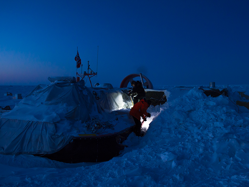
The icebreaker brought along the hovercraft R/V Sabvabaa (an Inuit name meaning “flows swiftly over it”) to assist in this endeavor (Figure 2). The 11-meter-long hovercraft, with its 2.2-ton payload, is outfitted as a polar research platform. It is capable of carrying out many of the same measurements as a modern deep-sea research vessel [Kristoffersen and Hall, 2014].

The hovercraft platform provided living quarters, data logging, and communication facilities. An enclosed workspace was set up and connected to the hovercraft. This workspace contained a “hydrohole,” an access hole through the ice for the air gun (for seismic reflection measurements) and winch operations for lowering the sediment corer, rock dredge, camera sled, and conductivity-temperature-depth (CTD) instrument.

A Mobile Platform
Ice activity forced us to relocate our station four times. Twice, the camp area was totally disrupted. In one of these incidents, an advancing pressure ridge completely annihilated our camp, and we lost two oceanographic instruments (Figure 3).
Relocation was not onerous, however, thanks to our mobile hovercraft platform (the video below shows the R/V Sabvabaa in operation). The logistic mobility of the hovercraft platform played a key role in reducing the inconvenience of relocating the research station over the 11.5 months it was deployed. This was especially important because the station was managed by a crew of only two people.
Collecting Data in Subzero Temperatures
Once we had the ice station set up, we began taking data. We monitored the annual energy budget at the surface using a weather station and by measuring incoming and outgoing short- and long-wave radiation. Below the ice, we suspended a 300-meter-long chain of thermistors at 10-meter intervals to monitor upward heat transport. We monitored upper ocean currents, down to 500 meters, with an acoustic Doppler current profiler. We used two recording current meters suspended at 200 and 800 meters to measure the deeper currents.
The hovercraft platform provided living quarters, data logging, and communication facilities.
The main focus of our marine geophysics and geology measurements involved obtaining 1000 kilometers of single-channel seismic reflection data along the track, penetrating about 1.5 kilometers below the ocean floor, which we successfully achieved. Our goal was to obtain data along as much of the track as possible. We consider 1000 kilometers a great achievement, considering that we operated for 85 days at temperatures below −30°C and 15 days below −40°C.
We had planned to carry out sediment sampling with a hydrostatically boosted sediment corer, but when temperatures remained below −30°C, we were forced to return to a light corer, which recovered 12 short cores, each less than 1 meter long.
We measured ocean depths at the site of the camp and with five autonomous echo sounder buoys placed as far as 6 kilometers away from the camp. To explore the seabed, we used a towed camera sled at 17 locations in water depths ranging from 800 to 2650 meters.
Expedition Produces Results
The expedition obtained new data relevant to a number of important aspects of Arctic science. We established the areal extent of an unconformity, or break in the sedimentary record, that extends across the top of the Lomonosov Ridge and jumps from Eocene to Mesozoic at the 2004 Arctic Coring Expedition drill site [Moran et al., 2006].
The advantages of mobility and low cost hold promise for a new generation of compact and efficient ice drift stations based on hovercraft technology.
We also observed deformed sediments along the foot of the ridge, which are probably related to shearing parallel to the ridge that occurred at some stage of Amerasia Basin evolution [Cochran et al., 2006]. Much to our surprise, the Morris Jesup Spur appears to be underlain by northwest dipping sediments rather than a pile of volcanics [Feden et al., 1979].
In addition, we saw and recorded two species of half-meter-long eelpouts (Gaidropsarus argentatus and Lycodes frigidus) at the sea bottom at 10 locations in water depths of 800 to 2080 meters. The Arctic Biodiversity Assessment report had not listed Gaidropsarus argentatus among the 13 species of fish found in the Arctic Central Basin, so finding this life at such depths will force ecologists to rethink the eelpouts’ species ranges.
Reviving a Western Presence in the Arctic
The former Soviet Union and Russia have maintained ice drift station activity more or less continuously since 1950. In contrast, the last time a Western sea ice station has remained occupied throughout the winter was September 1960 to March 1961, when Arctic Research Laboratory Ice Station I (ARLIS 1), operated by the Arctic Research Laboratory of the U.S. Office of Naval Research, spent the winter atop Fletcher’s Ice Island, an iceberg adrift in the Arctic Ocean. And before that, the last ice drift station deployed by Norway and Germany in the central Arctic Ocean was Fridtjof Nansen’s legendary drift with the ship Fram, 118 years ago.
Our deployment site, the Lomonosov Ridge, is a linear, 3-kilometer-high, flat-topped submarine ridge of continental rocks. It divides the Arctic Ocean basin into two age provinces: the Cenozoic Eurasia Basin and the Mesozoic Amerasia Basin [Wilson, 1963]. The Fram-2014/15 ice station crossed this submarine mountain chain five times. Half of this drift track crossed areas previously inaccessible to surveys by Western icebreakers—even when they were accompanied by a nuclear icebreaker (Figure 1).

Ice Stations for a Changing Arctic
The thickness and area of the Arctic Ocean sea ice cover are changing, and it is increasingly difficult to find suitable multiyear ice floes for scientific studies [Kwok and Rothrock, 2009; Lindsay and Schweiger, 2015]. Thus, the Arctic and Antarctic Research Institute in St. Petersburg, Russia, has announced that Russia will no longer maintain year-round drifting stations in the Arctic Ocean [Staalesen, 2012].
In this changing environment, the joint operation between an icebreaker and a hovercraft presented a win-win situation that enabled access to areas out of reach for icebreaker surveys. The advantages of mobility and low cost hold promise for a new generation of compact and efficient ice drift stations based on hovercraft technology.
Acknowledgments
We thank our cooperating partner, Alfred Wegener Institute for Polar and Marine Research, Germany, for showing us the confidence in deployment of Fram-2014/15. The two support missions by the 333 Squadron of the Norwegian Air Force and one by the Danish Air Force ensured continued science operations. Advice from A. Heiberg (University of Seattle), Griffon Hoverwork (Southampton), H. Berge, G. Hope, and O. Meyer (University of Bergen) was crucial to maximize uptime throughout the year and contributed to the safety of the expedition. The expedition was made possible by Blodgett-Hall Polar Presence providing the hovercraft platform and support supplemented by Lundin Norway and the Norwegian Petroleum Directorate.
References
Cochran, J. R., M. H. Edwards, and B. J. Coakley (2006), Morphology and structure of the Lomonosov Ridge, Arctic Ocean, Geochem. Geophys. Geosyst., 7, Q05019, doi:10.1029/2005GC001114.
Feden, R. H., P. R. Vogt, and H. S. Fleming (1979), Magnetic and bathymetric evidence for the “Yermak hot spot” northwest of Svalbard in the Arctic basin, Earth Planet. Sci. Lett., 44, 18–38.
Jokat, W., G. Uenzelmann-Neben, Y. Kristoffersen, and T. Rasmussen (1992), Lomonosov Ridge—A double sided continental margin, Geology, 20, 887–890.
Kristoffersen, Y., and J. K. Hall (2014), Hovercraft as a mobile science platform in the Arctic Ocean, Oceanography, 27(2), 170–179, doi:10.5670/oceanog.2014.33.
Kristoffersen, Y., J. K. Hall, K. Hunkins, J. Ardai, B. J. Coakley, J. R. Hopper, and Helay 2005 Seismic Team (2009), Extensive local seabed disturbance, erosion and mass wasting on Alpha Ridge, Central Arctic Ocean: Possible evidence for an extra-terrestrial impact?, Norw. J. Geol., 88, 313–320.
Kwok, R., and D. A. Rothrock (2009), Decline in Arctic sea ice thickness from submarine and ICESat records: 1958–2008, Geophys. Res. Lett., 36, L15501, doi:0.1029/2009GL039035.
Lindsay, R., and A. Schweiger (2015), Arctic sea ice thickness loss determined using subsurface, aircraft, and satellite observations, Cryosphere, 9, 269–283, doi:10.5194/tc-9-269-2015.
Moran, K., et al. (2006), The Cenozoic palaeoenvironment of the Arctic Ocean, Nature, 441, 601–605, doi:10.1038/nature04800.
Staalesen, A. (2012), Russian Arctic research on thin ice, Barents Observer, 6 Dec.
Stein, R. (Ed.) (2015), The expedition PS87 of the Research Vessel Polarstern to the Arctic Ocean in 2014, Rep. Polar Mar. Res. 688, 273 pp., Alfred Wegener Inst. for Polar and Mar. Res., Bremerhaven, Germany.
Wilson, J. T. (1963), Hypothesis of the Earth’s behavior, Nature, 197, 536.
Author Information
Yngve Kristoffersen and Audun Tholfsen, Nansen Environmental and Remote Sensing Center, Department of Earth Science, University of Bergen, Bergen, Norway; email: [email protected]; John K. Hall (retired), Geological Survey of Israel, Jerusalem, Israel; and Ruediger Stein, Alfred Wegener Institute of Polar and Marine Research, Bremerhaven, Germany
Citation:
Kristoffersen, Y.,Tholfsen, A.,Hall, J. K., and Stein, R. (2016), Scientists spend Arctic winter adrift on sea ice, Eos, 97, https://doi.org/10.1029/2016EO060711. Published on 11 October 2016.
Text © 2016. The authors. CC BY-NC 3.0
Except where otherwise noted, images are subject to copyright. Any reuse without express permission from the copyright owner is prohibited.