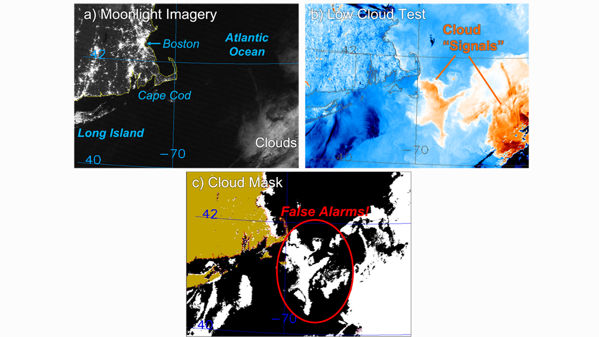
• About
  • Sections
  • Topics
    • Climate
    • Earth Science
    • Oceans
    • Space & Planets
    • Health & Ecosystems
    • Culture & Policy
    • Education & Careers
    • Opinions
  • Projects
    • ENGAGE
    • Editors’ Highlights
    • Editors’ Vox
    • Eos en Español
    • Eos 简体中文版
    • Print Archive
  • Blogs
    • Research & Developments
    • The Landslide Blog
  • Newsletter
  • Submit to Eos
  • AGU.org
  • Career Center
  • Join AGU
  • Give to AGU
  • About
  • Sections
  • Topics
    • Climate
    • Earth Science
    • Oceans
    • Space & Planets
    • Health & Ecosystems
    • Culture & Policy
    • Education & Careers
    • Opinions
  • Projects
    • ENGAGE
    • Editors’ Highlights
    • Editors’ Vox
    • Eos en Español
    • Eos 简体中文版
    • Print Archive
  • Blogs
    • Research & Developments
    • The Landslide Blog
  • Newsletter
  • Submit to Eos
Skip to content
  • AGU.org
  • Career Center
  • Join AGU
  • Give to AGU
Eos

Eos

Science News by AGU

Support Eos
Sign Up for Newsletter
  • About
  • Sections
  • Topics
    • Climate
    • Earth Science
    • Oceans
    • Space & Planets
    • Health & Ecosystems
    • Culture & Policy
    • Education & Careers
    • Opinions
  • Projects
    • ENGAGE
    • Editors’ Highlights
    • Editors’ Vox
    • Eos en Español
    • Eos 简体中文版
    • Print Archive
  • Blogs
    • Research & Developments
    • The Landslide Blog
  • Newsletter
  • Submit to Eos

satellites

An active sun in June 2013
Posted inResearch Spotlights

How Accurate Are Our Measurements of the Sun’s Energy?

Elizabeth Thompson by Elizabeth Thompson 13 April 20206 December 2022

As instruments collecting solar data degrade, researchers must correct for errors. A new study compares several methods to correct solar spectral irradiance measurements.

A satellite image showing a pumice raft floating on the ocean surface near Fiji and Tonga on 21 August 2019
Posted inScience Updates

Satellite Sleuthing Detects Underwater Eruptions

by P. A. Brandl 31 March 202018 January 2022

Satellite data helped scientists locate the volcanic source of a pumice raft floating in the South Pacific Ocean, illustrating their promise in locating and monitoring undersea eruptions.

Map of China and surroundings showing GPS-measured crustal velocities and large earthquakes
Posted inResearch Spotlights

Space-Based Data Expand Understanding of Crustal Deformation

Kate Wheeling, freelance science writer by Kate Wheeling 27 March 202029 September 2021

Researchers used the largest GPS data set yet to examine deformation of the crust across continental China and its implications for tectonic activity.

Aerial photo of a ship in an oil slick
Posted inNews

Leveraging Satellite Sensors for Oil Spill Detection

Sarah Derouin, Science Writer by Sarah Derouin 26 March 202018 May 2022

By using multiple remote sensors, scientists can quickly estimate the nature and thickness of oil spills—important factors for containment efforts.

Man-made objects larger than 10 centimeters in Earth orbit as of July 2009
Posted inEditors' Highlights
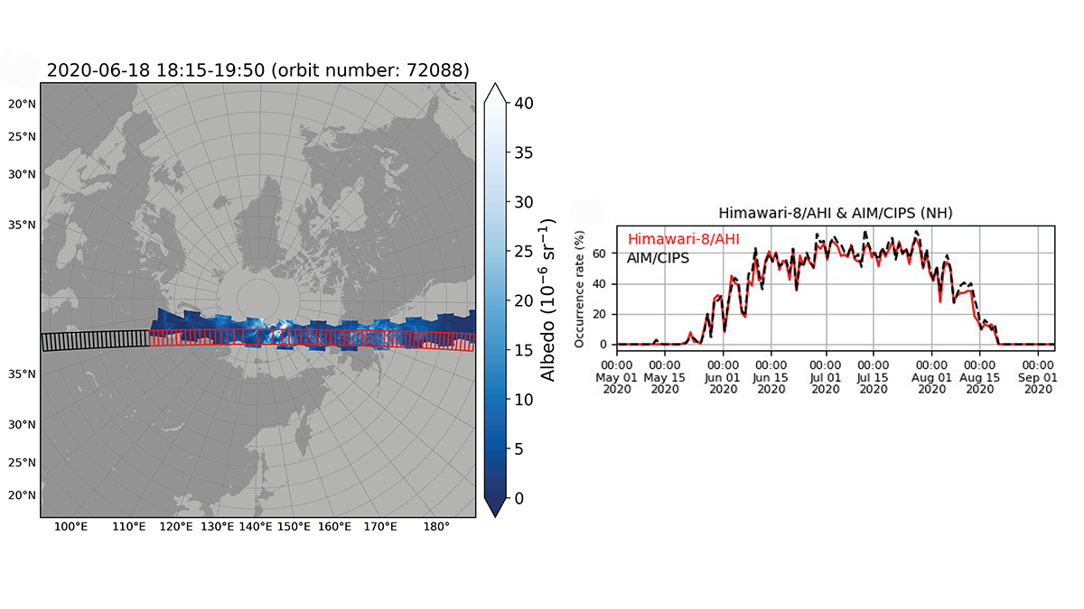
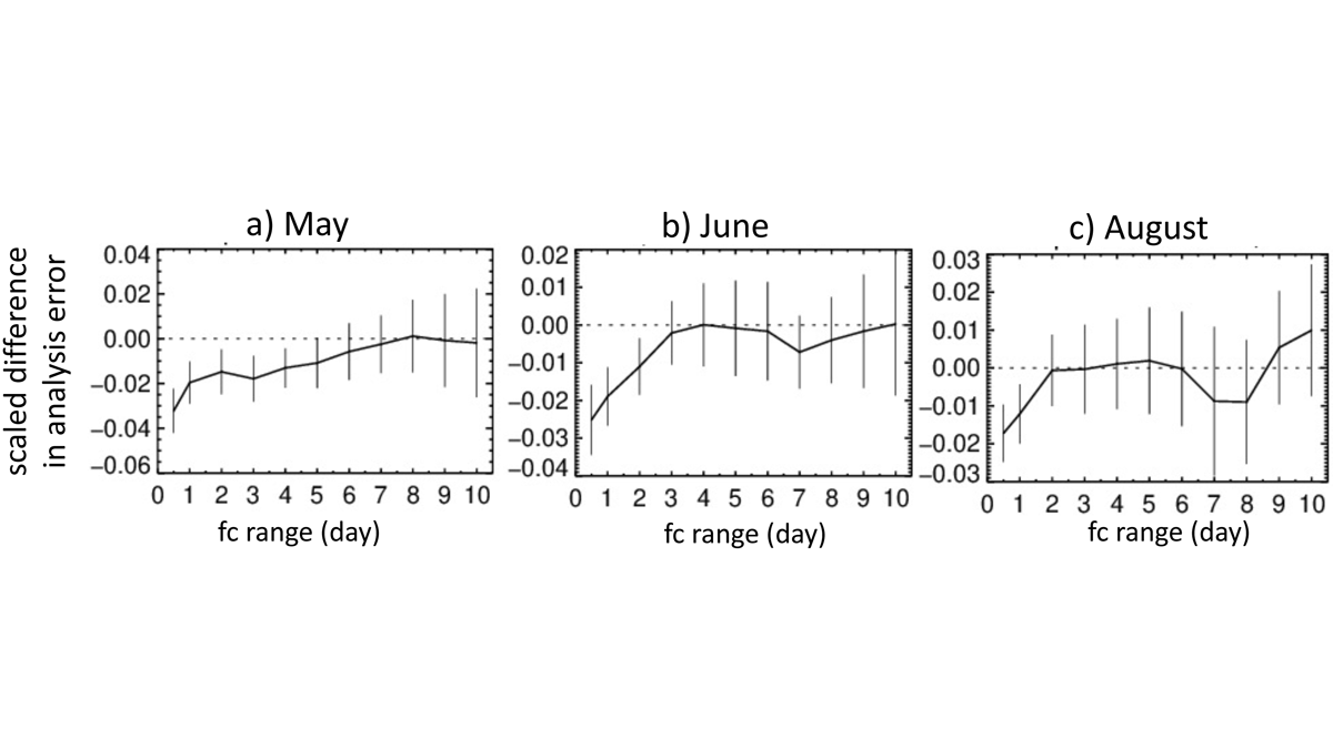
Space Traffic Management: Better Space Weather Forecasts Needed

by Michael A. Hapgood 27 February 202013 October 2021

Better forecasts of space-weather driven changes in thermospheric density are urgently needed to ensure safe management of the rapidly growing volume of space traffic in low Earth orbit.

NASA’S ICON satellite
Posted inNews

How to Launch a Satellite During a Blackout

Jenessa Duncombe, Staff Writer by Jenessa Duncombe 29 January 202012 December 2022

PG&E shut down the power to Berkeley’s Space Sciences Laboratory right before a satellite launch.

Smoke plumes spread west from the Camp Fire in Northern California and the Hill and Woolsey Fires in Southern California on 9 November 2018, as seen in this image captured by the Moderate Resolution Imaging Spectroradiometer (MODIS) on NASA’s Terra satellite.
Posted inScience Updates

A Global Perspective on Wildfires

by R. Kahn 27 January 20205 September 2023

Satellites provide global-scale data that are invaluable in efforts to understand, monitor, and respond to wildfires and emissions, which are increasingly affecting climate and putting humans at risk.

The International Space Station orbits through the thermosphere in May 2010.
Posted inResearch Spotlights

Atmospheric Drag Alters Satellite Orbits

by David Shultz 23 January 202013 October 2021

A new modeling study shows how the density of the thermosphere influences the paths of satellites in low Earth orbit.

Orange and red shading on map denotes higher levels of nitrogen oxide clusters around lignite power plants in Germany.
Posted inNews

Pinpointing Emission Sources from Space

Mary Caperton Morton, Science Writer by Mary Caperton Morton 2 January 202014 March 2023

Satellite data combined with wind models bring scientists one step closer to being able to monitor air pollution from space.

A continuously telemetered mountaintop GNSS station located on the Olympic Peninsula of Washington state
Posted inFeatures

Seismic Sensors in Orbit

by T. I. Melbourne, D. Melgar, B. W. Crowell and W. M. Szeliga 26 December 201923 February 2023

Navigation satellites are enabling high-precision, real-time tracking of ground displacements, supplementing traditional methods for monitoring and assessing earthquakes.

Posts pagination

Newer posts 1 … 14 15 16 17 18 … 25 Older posts
A view of a Washington, D.C., skyline from the Potomac River at night. The Lincoln Memorial (at left) and the Washington Monument (at right) are lit against a purple sky. Over the water of the Potomac appear the text “#AGU24 coverage from Eos.”

Features from AGU Publications

Research Spotlights

A Solar Wind Squeeze May Have Strengthened Jovian Aurorae

1 August 20251 August 2025
Editors' Highlights

What Goes Up Must Come Down: Movement of Water in Europa’s Crust

31 July 202531 July 2025
Editors' Vox

JGR: Space Physics Launches New Instrumentation Article Type

23 July 202521 July 2025
Eos logo at left; AGU logo at right

About Eos
ENGAGE
Awards
Contact

Advertise
Submit
Career Center
Sitemap

© 2025 American Geophysical Union. All rights reserved Powered by Newspack