
How hot is an extinct volcano? It depends on how deep you look. A magmatic dike of 1-meter thickness intruding near Earth’s surface will solidify within a few weeks. A thick magmatic reservoir formed at midcrustal level will need a much longer time to solidify, and the resulting heat anomaly can be present for some hundred thousand years.
For the past 25 years, production has been accompanied by a small but steady increase in seismicity near geothermal wells.
Such long-lasting, natural reservoirs of heat represent a perfect energy source for geothermal exploitation: Water injected into the ground reaches the still-hot core of the volcano, where it heats up and produces steam. Depending on temperatures, the heated water can be used to produce electric energy, either directly—the steam then drives turbines—or by heat exchange with a fluid having a lower evaporation point.
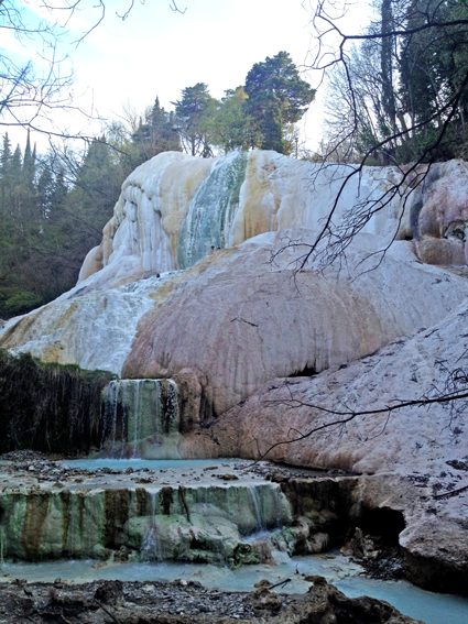
The picturesque landscape of Tuscany, Italy, is home to such an extinct volcano: Mount Amiata. Scientists estimate that the volcano’s last period of eruptive activity occurred about 200,000 years ago. Still characterized by a high geothermal gradient, the area lends itself to steam-dominated geothermal exploitation.
After nearly a century of generating geothermal power, energy extraction in Tuscany might be entering a new phase. For the past 25 years, production has been accompanied by a small but steady increase in seismicity near geothermal wells. Tuscan communities are beginning to wonder: Does generating power trigger this seismicity? A new project seeks answers.
Tuscan Geothermal Fields
Beneath the Tuscan geothermal fields, seismicity is exclusively observed in the upper crust and is confined at depth by the so-called K horizon, a strong seismic reflector revealed by intensive exploration and prospecting. The horizon is interpreted as a surface representing temperatures that reach 400°C. Below this, the crust becomes more ductile and less prone to seismic events.
The K horizon is observed in the Tuscan geothermal fields at depths as small as 4500 meters [Batini et al., 2003]. Structures above this horizon contain permeable layers of highly fractured, volcanic rocks. Rainfall draining through these layers heats up, saturating the rocks with hot water and steam.
Because hot areas are so close to the surface, communities dating back to Roman times harnessed the hot springs as therapeutic baths. In 1904, gentleman scientist Prince Piero Ginori Conti tested the world’s first geothermal power generator—successfully lighting five light bulbs—in Tuscany’s Larderello district. In 1911, Larderello became home to the world’s first commercial geothermal power plant. In fact, until 1958, Tuscany was the only area in the world producing geothermal energy.
More plants were built in volcanic areas of Tuscany and Latium in the 1960s, including several near Mount Amiata and Latera, and production across the Tuscan geothermal fields has continuously increased ever since. Today, geothermal energy from Tuscany accounts for 1.5% and 23.5% of energy produced in Italy and Tuscany, respectively, and 8% of geothermal energy produced around the world.
The Geothermal Field of Mount Amiata
Scientists consider shallow intrusive magma bodies to be the heat sources of two of Tuscany’s most important geothermal areas, Larderello and Mount Amiata. However, the two areas do have their differences: While in the Larderello area the magma ascent became stuck in the upper crust, in the Mount Amiata area, magma reached higher into superficial layers, and the eruptive activity formed a volcanic edifice, reaching an altitude of 1738 meters [Gianelli et al., 1997].
Geothermal exploitation at Mount Amiata Volcano started in 1959, through wells reaching initial depths of less than 1000 meters. Because the geothermal temperatures rise 15°C each hundred meters or so, such relatively shallow drilling depths were sufficient for the extraction of vapor and reinjection of cold water, using the natural fracture system of the rock volume for the circulation of the fluids.
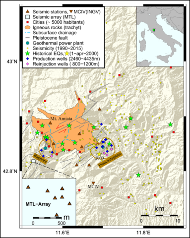
Nowadays, the geothermal energy company Enel Green Power runs two power plants of 60 megawatts each, Piancastagnaio and Bagnore, located in the southeast and southwest parts, respectively, of Mount Amiata (Figure 1). Both plants harness hydrothermal systems, meaning that energy production requires no pressurized fluid injection to enhance the permeability of fluid pathways, because the upper crust there is highly permeable. Reinjected fluids simply sink by gravity.
The Seismic Activity of Mount Amiata
Compared to other Italian areas, the recorded seismic activity at and around Mount Amiata is generally very low. The Italian Seismological Instrumental and Parametric Database reports no more than 140 seismic events with a magnitude greater than or equal to 1.5 for the past 25 years (Figure 1). This may be caused, in part, by the limited detection capabilities of the sparse regional Istituto Nazionale di Geofisica e Vulcanologia (INGV) seismic network (MCIV in Figure 1), but on the other hand, the high heat flow and the consequential ductile behavior of the upper crust may be the reasons for this low seismic activity. How much seismicity an extinct but still hot volcano generates is up for debate.
Damaging earthquakes struck the geothermal fields in south Tuscany long before geothermal exploitation started. The Parametric Catalog of Italian Earthquakes reports 13 moderate seismic events 4.5 ≤ Me ≤ 5.3 between 1287 and 1940 on the basis of inferences of observed effects of historic earthquakes using the Modified Mercalli Intensity Scale [Rovida et al., 2011].
In recent times, an earthquake on 1 April 2000 (Figure 1) has raised the strongest concern among the general public for several reasons. First, its very shallow hypocentral depth was responsible for damaging more than 50 buildings at Piancastagnaio. Also, the proximate location of the geothermal power plant with respect to the macroseismic epicenter raised strong doubts about the natural origin of this earthquake.
In addition, reports of different magnitudes, ranging from local magnitude (ML) = 3.9 to moment magnitude (Mw) = 4.5, were presented without context [Castello et al., 2006; Rovida et al., 2011]. Local magnitudes are felt in close proximity to the epicenter, whereas moment magnitudes incorporate low-frequency seismic information to reflect the broader area ruptured. The use of both values caused confusion and did not help to mitigate the population’s distrust of the institutions reporting on the earthquake.
Because the earthquake’s hypocenter was located near the geothermal power plant, at a depth (~4 kilometers) similar to the geothermal well depth, it was difficult to determine whether the earthquake source was natural or anthropogenic. Thus, our seismic array and network was developed to shed some additional light on what triggers earthquakes in this area.
The Geothermal Reservoir
Mazzoldi et al. [2015] report that pressure has continuously decreased over several decades inside the upper geothermal reservoir. This decrease led the power company Enel to deepen the production in the 1980s into a second reservoir, located at a depth of 2500–3500 meters. Continuous exploitation reduced the fluid pressure at these depths from 25 megapascals to less than 10 megapascals.
Vaporization and reinjection with cold water may lead to thermal stressing of rocks.
This strong pressure drop inside the geothermal reservoir could lead to the vaporization of originally water-dominated fluid. Vaporization and reinjection with cold water may lead to thermal stressing of rocks. Additionally, depletion of fluid from the reservoir may also induce elastic stresses in surrounding rock [Dahm et al., 2015].
These mechanisms may lead to both stabilizing and destabilizing effects on faults. For example, decreasing pore pressure on a fault is usually assumed to stabilize, or lock, the fault. The elastic bending of geological layers has been discussed as a mechanism to trigger earthquakes.
Public Concerns
Following the nuclear accident in Fukushima, Japan, caused by an Mw = 9.0 earthquake in 2011, Italy—which has no active nuclear plants—shut down by a national referendum all future plans for nuclear power plants. This raised a gold rush–like interest in domestic alternative energy production—solar, eolian, and geothermal, the latter motivated by the favorable geological conditions in central Italy.
Despite the general environmental sustainability of geothermal energy, major criticism from local citizens’ action committees concerns possible contamination of the groundwater by dissolution of mercury and the possibility of triggering earthquakes due to changes in thermal stresses and strong pressure drop as a consequence of the continuous energy production. Our project aims exclusively at the latter point.
A Seismic Network
Researchers installed a seismic network and small-aperture seismic array in the vicinity of Tuscany’s geothermal power plants.
To monitor the seismic activity inside the geothermal field, researchers installed an eight-station seismic network and a seven-element small-aperture seismic array in 2015 in the vicinity of Tuscany’s geothermal power plants (Figure 1). During the first 24 hours of recording, the array and the neighboring network stations recorded an M = 0.5 seismic event in the vicinity of the geothermal field of Bagnore (Figure 1). Since then, scientists have continued to record regular microearthquake activity.
The Challenge: Discriminating Natural from Anthropogenic Seismicity
The main challenge of the seismic array and network in the Mount Amiata area is to identify possible seismic events caused by human operations. The monitoring capabilities of the recording system permit a lowering of the detection threshold for local seismic events, determining, on very fine scales, the exact location of the earthquake’s hypocenter, especially in the vicinity of the industrial operations, and calculating the physical focal mechanism of the seismic source.
Array techniques and relative location methods will be used for a precise hypocentral determination. Seismic events that are of volcanic origin, rather than tectonic, will be filtered out using polarization and spectral analysis. The crust, which is affected by simultaneous fluid extraction and reinjection, represents a complex system: In addition to the pore pressure variations on the single fault, thermal stresses and phase transitions get induced by the temperature difference of the cold fluid mixing into the hot rock volume. Therefore, scientists are also conducting fluid-fault interaction studies and physical modeling of the area, which will allow them to estimate how much these effects contribute to inducing earthquakes.
Acknowledgments
The installation of the seismic array/network was realized in the framework of a student course on array seismology; we are therefore grateful to M. Caciagli, D. Famiani, A. Gattuso, T. Jacobi, J. Klose, C. Mascandola, M. Pastori, G. Petersen, F. Sandring, E. Türker, and our field technician R. Bauz. Marcello Cinci and Rebecca Spinelli (Enel Green Power) kindly supported logistics and site selection. The array course was cofinanced by the Earthquake Department of INGV. The seismic recording equipment was provided by the Institute for Geo- and Environmental Sciences of the University of Potsdam and the GFZ German Research Centre for Geosciences.
References
Batini, F., A. Brogi, A. Lazzarotto, D. Liotta, and E. Pandeli (2003), Geological features of Larderello–Travale and Mt. Amiata geothermal areas (southern Tuscany Italy), Episodes, 26, 239–244.
Castello, B., G. Selvaggi, C. Chiarabba, and A. Amato (2006), CSI Catalogo della sismicità italiana 1981–2002, versione 1.1, Centro Naz. Terremoti, Ist. Naz. di Geofis. e Vulcanol., Rome. [Available at https://csi.rm.ingv.it/.]
Dahm, T., S. Cesca, S. Hainzl, T. Braun, and F. Krüger (2015), Discrimination between induced, triggered, and natural earthquakes close to hydrocarbon reservoirs: A probabilistic approach based on the modeling of depletion-induced stress changes and seismological source parameters, J. Geophys. Res., 120(4), 2491–2509, doi:10.1002/2014JB011778.
Gianelli, G., A. Manzella, and M. Puxeddu (1997), Crustal models of the geothermal areas of southern Tuscany (Italy), Tectonophysics, 281, 221–239.
Mazzoldi, A., A. Borgia, M. Ripepe, E. Marchetti, G. Ulivieri, M. della Schiava, and C. Allocca (2015), Faults strengthening and seismicity induced by geothermal exploitation on a spreading volcano, Mt. Amiata, Italia, J. Volcanol. Geotherm. Res., 301, 159–168.
Rovida, A., R. Camassi, P. Gasperini, and M. Stucchi (Eds.) (2011), CPTI11, the 2011 version of the Parametric Catalogue of Italian Earthquakes, Ist. Naz. di Geofis. e Vulcanol., Milan, Italy. [Available at https://emidius.mi.ingv.it/CPTI.]
Author Information
Thomas Braun, Seismology and Tectonophysics, Arezzo Observatory, Istituto Nazionale di Geofisica e Vulcanologia, Arezzo, Italy; email: [email protected]; Torsten Dahm, Sektion 2.1., GFZ German Research Centre of Geosciences, Potsdam, Germany; Frank Krüger and Matthias Ohrnberger, Institut für Erd- und Umweltwissenschaften, Universität Potsdam, Potsdam, Germany
Citation:
Braun, T.,Dahm, T.,Krüger, F., and Ohrnberger, M. (2016), Does geothermal exploitation trigger earthquakes in Tuscany?, Eos, 97, https://doi.org/10.1029/2016EO053197. Published on 31 May 2016.
Text © 2016. The authors. CC BY-NC-ND 3.0
Except where otherwise noted, images are subject to copyright. Any reuse without express permission from the copyright owner is prohibited.