• About
  • Special Reports
  • Topics
    • Climate
    • Earth Science
    • Oceans
    • Space & Planets
    • Health & Ecosystems
    • Culture & Policy
    • Education & Careers
    • Opinions
  • Projects
    • Postcards From the Field
    • ENGAGE
    • Editors’ Highlights
    • Editors’ Vox
    • Eos en Español
    • Eos 简体中文版
    • Print Archive: 2015–2025
  • Policy Tracker
  • Blogs
    • Research & Developments
    • The Landslide Blog
  • Newsletter
  • Submit to Eos
  • AGU.org
  • Career Center
  • Join AGU
  • Give to AGU
  • About
  • Special Reports
  • Topics
    • Climate
    • Earth Science
    • Oceans
    • Space & Planets
    • Health & Ecosystems
    • Culture & Policy
    • Education & Careers
    • Opinions
  • Projects
    • Postcards From the Field
    • ENGAGE
    • Editors’ Highlights
    • Editors’ Vox
    • Eos en Español
    • Eos 简体中文版
    • Print Archive: 2015–2025
  • Policy Tracker
  • Blogs
    • Research & Developments
    • The Landslide Blog
  • Newsletter
  • Submit to Eos
Skip to content
  • AGU.org
  • Career Center
  • Join AGU
  • Give to AGU
Eos

Eos

Science News by AGU

Support Eos
Sign Up for Newsletter
  • About
  • Special Reports
  • Topics
    • Climate
    • Earth Science
    • Oceans
    • Space & Planets
    • Health & Ecosystems
    • Culture & Policy
    • Education & Careers
    • Opinions
  • Projects
    • Postcards From the Field
    • ENGAGE
    • Editors’ Highlights
    • Editors’ Vox
    • Eos en Español
    • Eos 简体中文版
    • Print Archive: 2015–2025
  • Policy Tracker
  • Blogs
    • Research & Developments
    • The Landslide Blog
  • Newsletter
  • Submit to Eos

cool tools

san-andreas-fault-carrizo-plain-deep-earthquakes-show-tidal-patterns
Posted inNews

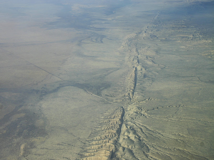
Tiny, Deep Quakes Increase on San Andreas as Tides Tug on Fault

Amy Coombs by A. Coombs 26 July 20166 October 2021

When the gravity of the Sun and Moon causes Earth's crust to bulge every 2 weeks, slow-moving earthquakes proliferate in the lower reaches of the San Andreas, a new study finds.

US crustal thickness map.
Posted inResearch Spotlights

Novel Technique Finds New Features Under United States

by Terri Cook 29 June 201627 January 2023

A new high-fidelity tomography harnesses USArray data to expose a wealth of noteworthy crustal and upper mantle structures, including previously unknown anomalies beneath the Appalachians.

As a previously envisioned way to build lunar habitats using three-dimensional printing, the European Space Agency in 2013 described creating this sort of structure on the Moon starting with an inflatable dome.
Posted inNews

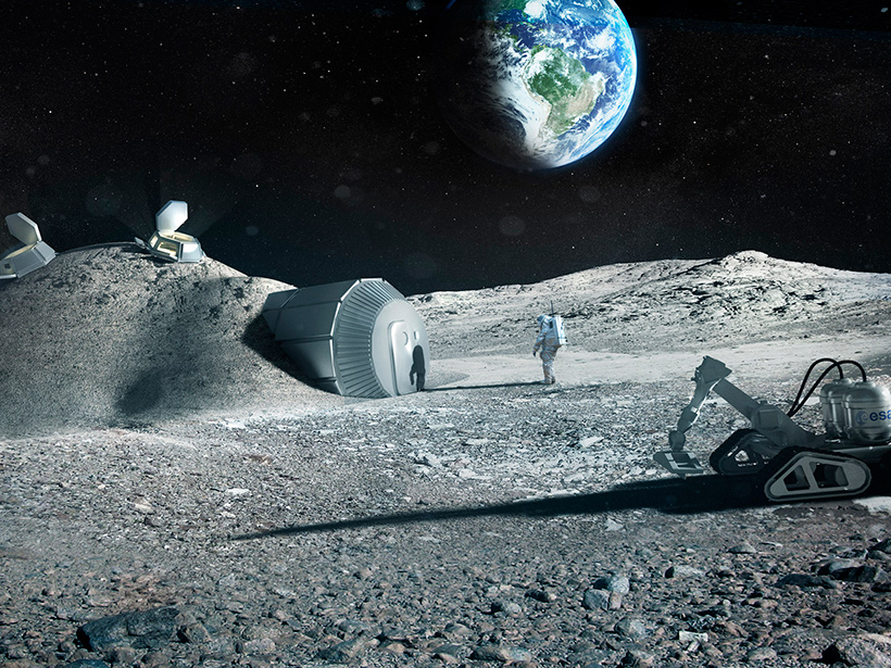
Could 3-D Printers Create Shelters for Future Lunar Settlers?

by M. ter Voorde 31 May 201626 January 2022

Test of a novel solar-powered printer yielded a prototype construction brick made from simulated lunar soil.

Airplane in storm clouds
Posted inNews

Storms Cause Infrequent Turbulence for Aircraft, New Study Finds

by E. Deatrick 25 May 201620 January 2023

Scientists using lightning sensors to automate air-turbulence detection have found evidence that storms jostle aircraft much less than previously thought.

Posted inNews

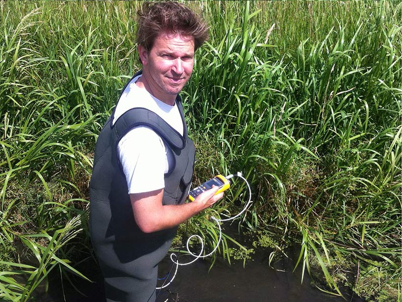
Temperature-Sensing Overalls Offer Scientific Promise

JoAnna Wendel, freelance science writer and illustrator by JoAnna Wendel 28 March 201613 January 2022

In a proof-of-concept experiment, researchers test out how well a pair of fisherman's waders can sense changes in water temperature.

Posted inResearch Spotlights

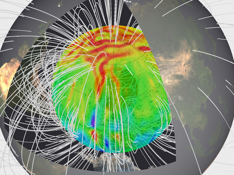
Which Geodynamo Models Will Work Best on Next-Gen Computers?

by Terri Cook 11 March 201630 September 2022

A new study uses identical tests to evaluate the accuracy and performance of current models of Earth's magnetic field, then extrapolates the results to anticipated "petascale" supercomputers.

Posted inNews

White House Showcases Earthquake Alerts, Federal Quake Readiness

by Randy Showstack 22 February 20165 December 2022

A prototype ShakeAlert early warning system approaches alert-ready status as the administration issues an executive order on federal earthquake standards.

Posted inScience Updates

Visualizing Cross-Sectional Data in a Real-World Context

by K. Van Noten 2 February 201622 August 2022

Combining the capabilities of an open-source drawing tool with Google Earth maps allows researchers to visualize real-world cross-sectional data in three dimensions.

Posted inOpinions

The Case for Multiuser Facilities

by R. Behnke and R. Robinson 29 January 201629 September 2021

As federal agencies look to slash costs, facilities become obvious targets. But cutting funds to these vital programs may have far-reaching consequences.

Posted inScience Updates

Using Sounds from the Ocean to Measure Winds in the Stratosphere

by M. Arrowsmith, Stephen J. Arrowsmith and O. Marcillo 4 January 201629 March 2022

Stratospheric winds deflect acoustic waves from the oceans. With the right data and the math to analyze them, these waves tell us about the weather aloft.

Posts pagination

Newer posts 1 … 32 33 34 35 36 37 Older posts
Over a dark blue-green square appear the words Special Report: The State of the Science 1 Year On.

Features from AGU Publications

Research Spotlights

Rocket Launches and Reentries Harm Earth’s Ozone Layer

8 June 20268 June 2026
Editors' Highlights

Pre-Existing Structure and Stress Shape Geothermal-Induced Seismicity

2 June 20261 June 2026
Editors' Vox

Small-Scale Indian Ocean Dynamics Underpin Marine Ecology and Climate

4 June 20263 June 2026
Eos logo at left; AGU logo at right

About Eos
ENGAGE
Awards
Contact

Advertise
Submit
Career Center
Sitemap

© 2026 American Geophysical Union. All rights reserved Powered by Newspack