

The Sunda subduction zone at Sumatra is well known as the source of the devastating 2004 Boxing Day earthquake and tsunami that inundated shorelines around the Indian Ocean. Geophysicists have studied this subduction zone, which parallels the coasts of western and southern Indonesian islands (Sumatra, Java, and others) offshore for much of its more than 5,000-kilometer length, in detail, especially since 2004. Far less known, however, is the Sumatran fault system, an onshore component of the tectonic boundary between the Indo-Australian plate to the west and the Burma and Sunda minor plates to the east. This system is one of the longest and most active strike-slip fault zones in the world, running along the 1,900-kilometer length of Sumatra.
The most seismically active region of the island is Aceh, in the far north of Sumatra. The 2004 tsunami severely affected Aceh, and its 4 million people remain vulnerable to earthquakes—particularly on the Sumatran fault and other nearby crustal faults, which run directly below dense population centers. Most recently, a magnitude 6.5 earthquake in December 2016 killed more than 100 people and caused an estimated $139 million in economic losses [Muzli et al., 2018]. A lot of seismicity, including the 2016 earthquake, occurs on fault segments that are poorly understood or often even unidentified before they are revealed by damaging seismic events [Muksin et al., 2019].
Earthquakes are produced by sudden slippage along faults caused by the buildup of stress. The occurrences and sizes of earthquakes are governed by the sizes of the areas on faults that are locked (accumulating stress that will eventually be released in an earthquake) or creeping (gradually moving, which reduces or prevents stress buildup). A detailed understanding of the distribution of creeping and locked areas in the Sumatran fault system is still missing, largely because of a paucity of geophysical monitoring. This shortage has limited the evaluation of seismic hazard and the understanding of activity and tectonic structures along the fault system.
We recently embarked on an effort to unravel key properties of the Sumatran fault system, using data acquired by a dense seismic network in the Aceh region. Beginning in January 2020, the seismology teams at the Earth Observatory of Singapore and at Syiah Kuala University in Banda Aceh, Indonesia, deployed the first phase of the network, comprising an array of more than 130 seismic nodes and several broadband seismometers. Many of the instruments were maintained until July 2021. The 18 months of data we collected will be invaluable in better understanding this major fault system.
Creeping and Locking in Aceh
Geodetic observations have revealed that a relatively straight portion of the Sumatran fault, running northwest–southeast through part of Aceh, is creeping [Ito et al., 2012; Tong et al., 2018] (Figure 1). This creeping section is bound on either end by fault bifurcations where the fault splits into two segments [Sieh and Natawidjaja, 2000]. At the northwestern split, the active Seulimeum and relatively inactive Aceh fault branches diverge, with the Seulimeum following a slightly more northerly trace.
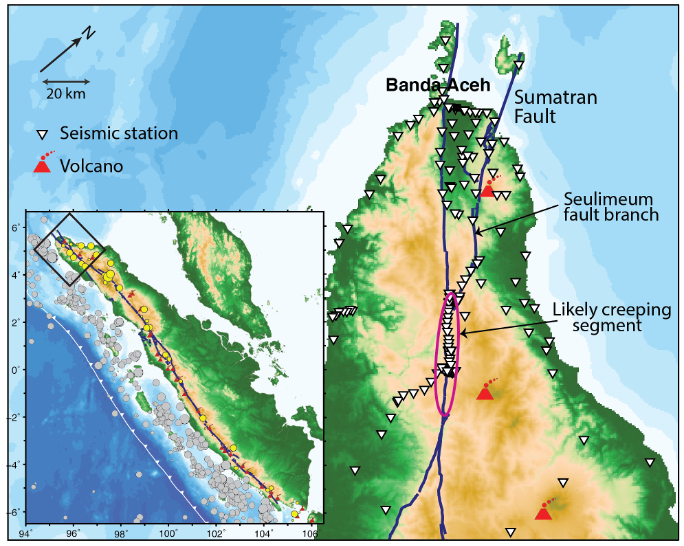
Past seismic activity along the locked Seulimeum segment is evident from escarpments and offsets in stream courses. This fault segment was the source of a damaging magnitude 7.3 earthquake in 1936 (and possibly a magnitude 6.5 event in 1964), although the future hazard it poses is unclear. Intriguingly, the inferred creeping segment hosted two recent magnitude 6 earthquakes, one in 1997 and one in 2013, and continues to exhibit very active microseismicity (very small earthquakes) [Muksin et al., 2019], suggesting that the fault here may be able both to host large earthquakes and to slip gradually. More analysis is needed to further reveal the slip distributions of the magnitude 6 earthquakes as well as how fault slip is modulated between these competing mechanisms. To help address these vital unknowns, we deployed our instruments around both the creeping segment and the Seulimeum fault branch.
One of the most common ways to confirm whether a fault is creeping and to measure the rate at which it is creeping is to look for repeating low-magnitude earthquakes.
One of the most common ways to confirm whether a fault is creeping and to measure the rate at which it is creeping is to look for repeating low-magnitude earthquakes, which are produced by small, locked patches of the fault that are loaded by the surrounding creeping region. Muksin et al. [2019] used a temporary deployment of seismic instruments in Aceh to detect a few hundred seismic events on the inferred creeping segment; however, the geographic density of these instruments and the deployment time were not sufficient to detect repeating earthquakes. Previous studies in the region also did not acquire sufficient data to constrain the distribution of creeping and locked areas of the Sumatran fault or to interpret fault morphology, structure, and frictional properties.
This information is crucial to model fault rupture and thus assess seismic risk accurately. Our densely sited nodal array presents an opportunity to detect smaller-magnitude seismicity below the sensitivity of Indonesia’s sparse national broadband seismic network. To maximize the opportunity to capture repeating earthquakes, we deployed our instruments for 18 months—a relatively long-duration deployment for a nodal array.
Into the Rain Forest
In early 2020, we began the first deployment of our nodal array in Sumatra. Our team included research fellows and master’s and Ph.D. students from both the Earth Observatory of Singapore and Syiah Kuala University. For many on the team, it was the first time they were participating in seismic data acquisition in the field, so it offered an opportunity to appreciate the value of hard-earned seismic data—far more so than simply downloading data from a database does.

We set up our data center (as well as our planning and training operations and our instrument charging stations) at the Tsunami and Disaster Mitigation Research Center in Banda Aceh, having shipped the seismic nodes and other equipment over from Singapore. Nodes are small, low-cost, self-contained seismic monitoring instruments that in contrast to expensive broadband seismometers, can be rapidly deployed across a wide range of settings. After several days of training and planning, we dispersed around Aceh in four groups, ensuring a mix of people from both institutes in each group.
Each team first met with local police and village heads to explain our project and engage them in the deployment. We then had to find sites for all of our nodes. We had scoped out potential locations using satellite imagery to identify sites that would be accessible by roads or tracks, but the real-world deployments were another, far trickier matter!
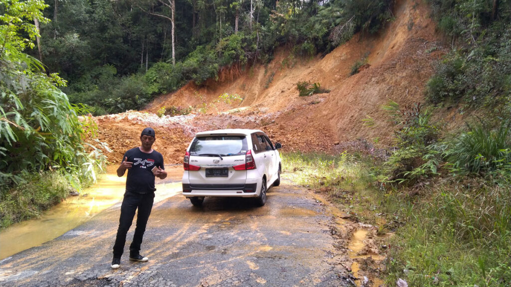
This difficulty arose partly because working in the rain forest brought many challenges. In addition to frequent encounters with leeches, biting ants, and mosquitoes, for example, the dense forest cover made it difficult for the instruments to obtain the GPS satellite signals needed to routinely calibrate and correct their internal clocks (without which we would not have accurate and consistent timing for detected seismic signals). We learned to seek out small plantations with regularly spaced crops of palm or cocoa trees when possible, as they offered less tree cover. The fieldwork wasn’t all about problem-solving, however. We also greatly enjoyed the bounty of the forest, gorging on such tropical fruits as durian, rambutan, and mangosteen straight from the trees.
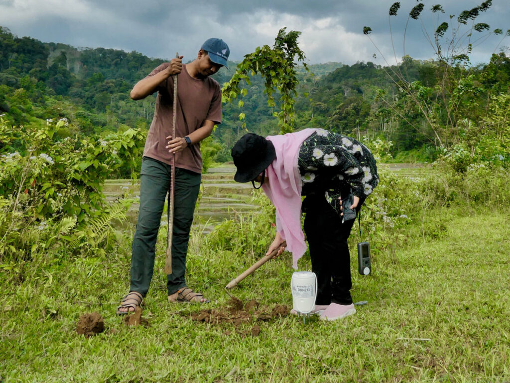
Often, we relied on local residents to assist us in finding sites or to host a node on their land. Talking with locals wasn’t always straightforward, though, because many people in rural Aceh do not speak the national Indonesian language and there are at least 10 different local languages spoken. Having diverse teams that included people from Aceh proved very fruitful for finding the best way to communicate. We were also fortunate to work with local drivers, including a retired comedian who is well known in the villages.
Many locals we talked to were familiar with earthquakes, having often experienced ground shaking, and were happy to contribute to earthquake research by hosting a seismometer on their land. Along the western coast of the island, residents had strong memories of the devastating 2004 tsunami, and several people we met had lost family members and livelihoods in the disaster. Hearing these firsthand accounts reinforced to our team, particularly the members from Singapore who had not experienced earthquakes and tsunamis before, the harsh realities of living with the threat of natural hazards, as well as the importance of our work.
Cue a Pandemic
The seismic nodes we used, primarily chosen for their relatively low cost and ease of deployment, made a survey of this scale affordable and practical. However, the nodes were originally designed for use in short-duration commercial surveys, and their battery life does not extend beyond 5 weeks. This limitation meant we had to go back into the field every few weeks to replace the instruments. After the nodes’ batteries were recharged and their data were harvested, they were redeployed in the next cycle.
In February 2020, the Singapore team members were grounded and unable to travel, so it fell to the Indonesian team to continue the regular fieldwork and take over control and maintenance of the equipment.
What no one saw coming was the COVID-19 pandemic. After the first recharging cycle, in February 2020, the Singapore team members were grounded and unable to travel for the rest of the 18-month deployment. It fell to the Indonesian team to continue the regular fieldwork and take over control and maintenance of the equipment. With tremendous effort and commitment, the members navigated local restrictions and enhanced their safety measures to do just that. Despite some periods when local restrictions prohibited fieldwork, the researchers managed to get into the field to swap out the nodes on average every 5 weeks. They also battled some extreme weather, at times facing heavy rains followed by landslides that occasionally blocked access to certain sites.
Frequent communication was critical to our team’s success in the first few months of acquisition, when the team members were becoming acquainted with the procedures, equipment, and rhythms of the project. This was especially true right after pandemic lockdowns were instituted, when the team members in Indonesia, who were just getting familiar with the equipment, suddenly had to sort out instrument problems on their own.
Thankfully, we had all met in person during the first few field cycles, forming good relationships and making sure everyone had at least minimum knowledge of how the instruments worked. Signal permitting, we used the WhatsApp messaging application to assist team members in the field with troubleshooting, for example, if there were problems initializing a node or finding a previous site. Back in the data center in Banda Aceh, the Singapore and Indonesia teams stayed connected by remotely logging in to the data system and through Zoom video chats. These chats helped to solve problems that came up when harvesting data from the nodes and with analyzing the data and planning adjustments for the next deployment cycle.
A New Chapter in Aceh Seismology
At the end of the first phase of the project in July 2021, we recovered 131 of the 138 nodes deployed in the field. The other seven were lost to machinery (e.g., one was dug up at a new construction site) or stolen or simply could not be found again. The pandemic caused us to adapt our operations on the fly and to adjust our goals for continuing work. Instead of moving the nodes to a new set of sites elsewhere in Aceh after the first deployment phase, as originally planned, we had to postpone the second phase.
These data will open a new chapter of seismology research in Aceh and help to address key questions about the Sumatran fault system.
Nonetheless, we have already gathered a unique and extensive new data set covering a major fault system that has historically received insufficient monitoring. These data will open a new chapter of seismology research in Aceh and help to address key questions about the Sumatran fault system. We expect, for example, that the detected seismicity will enable more accurate definition of the creeping and locking distribution along this section of the fault. The data may also help reveal how the creeping fault segment connects with the locked Seulimeum fault branch below the surface, what the maximum possible magnitude of future earthquakes hosted on this fault segment may be, and what fault zone structure looks like in detail and how that structure relates to both large earthquakes and creep.
The new data could also shed light on a tectonic puzzle: The Sumatran fault runs along a line of active arc volcanoes, the shape and location of which are highly correlated with the shape of the offshore subduction trench. How the arc-fault system interacts remains an open question. Information on how the depth of the seismogenic zone varies in relationship to volcanoes could prove useful, as could the basic observation of where the fault lies at depth rather than just its surface trace.
In our work with the data, we have already detected and located thousands of small earthquakes that are allowing us, for example, to map active fault branches clearly and to observe trends in seismicity with depth on the fault. And there is far more work to do. Ultimately, these new measurements represent the fruits of a successful international collaboration that effectively engaged local communities and overcame challenges, and they will be used to better understand the risks this hazardous fault system poses to those very same communities and to others across this seismically active area.
Acknowledgments
We thank the large team of people in Indonesia (including Eka Oktavianus, Wiwik Ayu Ningsih, Dian Darisma, Ridha Muhammad, and Muzli Muzli) and Singapore (including Weiwen Chen, Wardah Shafiqah, Phyo Maung Maung, Hongyu Zeng, and Qibin Shi) who made this fieldwork possible.
References
Ito, T., et al. (2012), Isolating along-strike variations in the depth extent of shallow creep and fault locking on the northern Great Sumatran Fault, J. Geophys. Res. Solid Earth, 117, B06409, https://doi.org/10.1029/2011JB008940.
Muksin, U., et al. (2019), AcehSeis project provides insights into the detailed seismicity distribution and relation to fault structures in Central Aceh, northern Sumatra, J. Asian Earth Sci., 171, 20–27, https://doi.org/10.1016/j.jseaes.2018.11.002.
Muzli, M., et al. (2018), The 2016 Mw 6.5 Pidie Jaya, Aceh, North Sumatra, earthquake: Reactivation of an unidentified sinistral fault in a region of distributed deformation, Seismol. Res. Lett., 89(5), 1,761–1,772, https://doi.org/10.1785/0220180068.
Sieh, K., and D. Natawidjaja (2000), Neotectonics of the Sumatran fault, Indonesia, J. Geophys. Res., 105(B12), 28,295–28,326, https://doi.org/10.1029/2000JB900120.
Tong, X., D. T. Sandwell, and D. A. Schmidt (2018), Surface creep rate and moment accumulation rate along the Aceh segment of the Sumatran fault from L-band ALOS-1/PALSAR-1 observations, Geophys. Res. Lett., 45(8), 3,404–3,412, https://doi.org/10.1002/2017GL076723.
Author Information
Karen Lythgoe ([email protected]), Earth Observatory of Singapore, Nanyang Technological University, Singapore; Umar Muksin and Arifullah, Tsunami and Disaster Mitigation Research Centre/Universitas Syiah Kuala, Banda Aceh, Sumatra, Indonesia; Andrean Simanjuntak, Badan Meteorologi, Klimatologi, dan Geofisika/Universitas Syiah Kuala, Banda Aceh, Sumatra, Indonesia; and Shengji Wei, Earth Observatory of Singapore, Nanyang Technological University, Singapore